In partnership with: 
|
December 31, 2009 at 8:00 am |
|
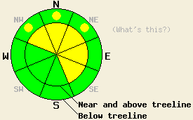
Near and above treeline, avalanche danger is MODERATE on NW-N-NE-E-SE aspects, 35 degrees and steeper. Below treeline, pockets of MODERATE danger exist in open areas on NW-N-NE aspects, 37 degrees and steeper. |
|
|
|
A series of weak weather systems continues to move through the forecast area. A break in the weather occurred late yesterday and overnight. Cloud cover has moved into the forecast area this morning. Ridgetop wind that were strong out of the southwest yesterday morning decreased to light and variable overnight. Winds have shifted back to the southwest this morning and are increasing in speed, forecast to become moderate to strong this afternoon. Light snow showers are expected for today. Storm totals for the last 24 hours are running 5 to 8 inches across the forecast area. Air temperatures along the Sierra Crest have a wide spread this morning due to variances in cloud cover.
Limited natural avalanche activity due to cornice collapse and a few skier triggered avalanches were observed or reported throughout the day yesterday. Strong winds created significant wind transport, wind loading lee areas near and above treeline on NW-N-NE-E-SE aspects with 2 to 3 feet of new snow. Naturally occurring cornice collapse triggered several avalanches with 1 to 2 foot crowns in the early morning hours on Mt. Judah (Donner Summit area) in heavily wind loaded near treeline terrain on N-NE-E aspect 38 to 48 degree slopes at 7,760' on Wildflower Ridge (photos) and at 8,200' in the summit bowl (photos). No other natural avalanche activity was observed or reported from the forecast area. Around 12:30 pm, a skier triggered avalanche occurred just south of the summit of Donner Pass near treeline on a NE aspect at approximately 7,200'. The avalanche was reported to have an 8 to 12 inch crown and was 100' wide. Around 5 pm, a larger skier triggered avalanche occurred on Angora Peak (Desolation Wilderness area) below treeline at 7,800' on a NW aspect, 40 degree slope in an obvious avalanche path. The crown was reported at 2 feet deep and 200' wide. The avalanche ran approximately 800' down slope. The avalanche fractured 50 to 75' above the skier who was caught and carried about 200' before grabbing a tree and escaping the avalanche (read the skiers account by clicking here). Snowpit data collected on Silver Peak (Pole Creek area) below treeline at 7,424' on a NNE aspect, 37 degree slope indicated that moderate force was sufficient to cause fracture propagation and failure just over 1 foot deep in the snowpack. The failure layer was identified as a thin layer of faceted crystals just below the December 21 rain crust (pit profile and video).
Avalanche concern #1:
New snow instability both above and below treeline. Some lingering instability is expected in areas where significant wind loading was occurred in the past 24 hours. Unstable slabs 1 to 2 feet deep are expected to continue to exist on steep NW-N-NE-E-SE aspects below ridgelines and cornice features. Below treeline, pockets of continued instability are expected on the colder and shadier NW-N-NE aspects in areas where a thin layer of faceted crystals exists around 1 foot deep in the snowpack, just below the thin Dec 21 rain crust. Avalanches will be harder to trigger today than yesterday. However, avalanches large enough to bury or injure a person remain possible.
Avalanche concern #2:
Deep slab instability involving the Oct 19 facet layer near the base of the snowpack is unlikely but not impossible in a few isolated areas below treeline on NE wind protected NW-N-NE aspects above 7,700'. Very strong snow in the middle and upper portions of the snowpack has kept this layer from failing in areas where it remains weak, keeping human triggering of this weak layer an unlikely event.
Near and above treeline, avalanche danger is MODERATE on NW-N-NE-E-SE aspects, 35 degrees and steeper. Below treeline, pockets of MODERATE danger exist in open areas on NW-N-NE aspects, 37 degrees and steeper.
| 0600 temperature: | 19 to 31 deg. F. |
| Max. temperature in the last 24 hours: | 23 to 31 deg. F. |
| Average wind direction during the last 24 hours: | Southwest |
| Average wind speed during the last 24 hours: | 35 mph |
| Maximum wind gust in the last 24 hours: | 71 mph |
| New snowfall in the last 24 hours: | 1 to 3 inches |
| Total snow depth: | 38 to 63 inches |
For 7000-8000 ft: |
|||
| Thursday: | Thursday Night: | Friday: | |
| Weather: | Cloudy skies with scattered snow showers. | Cloudy skies with scattered snow showers. | Cloudy skies with a chance of snow in the morning. Snow likely in the afternoon. |
| Temperatures: | 27 to 34 deg. F. | 20 to 27 deg. F. | 26 to 32 deg. F. |
| Wind direction: | SW | SW | SW |
| Wind speed: | 10 to 15 mph with gusts to 25 mph. | 10 to 20 mph with gusts to 35 mph. | 10 to 15 mph with gusts to 40 mph in the morning. Winds increasing to 20 to 30 mph with gusts to 55 mph in the afternoon. |
| Expected snowfall: | trace in. | trace in. | Up to 3 in. |
For 8000-9000 ft: |
|||
| Thursday: | Thursday Night: | Friday: | |
| Weather: | Cloudy skies with scattered snow showers. | Cloudy skies with scattered snow showers. | Cloudy skies with a chance of snow in the morning. Snow likely in the afternoon. |
| Temperatures: | 25 to 32 deg. F. | 20 to 27 deg. F. | 24 to 39 deg. F. |
| Wind direction: | SW | SW | SW |
| Wind speed: | 20 to 30 mph with gusts 45 to 60 mph in the morning. Winds increasing to 30 to 40 mph with gusts 55 to 70 mph inthe afternoon. | 25 to 40 mph with gusts to 65 mph. | 25 to 35 mph increasing to 30 to 45 mph in the afternoon. Gusts 60 to 75 mph. |
| Expected snowfall: | trace in. | trace in. | Up to 4 in. |


This website is owned and maintained by the non-profit arm of the Sierra Avalanche Center. Some of the content is updated by the USDA avalanche forecasters including the forecasts and some observational data. The USDA is not responsible for any advertising, fund-raising events/information, or sponsorship information, or other content not related to the forecasts and the data pertaining to the forecasts.

