In partnership with: 
|
January 14, 2010 at 8:00 am |
|
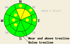
Near and above treeline MODERATE avalanche danger exists on wind-loaded N-NE-E aspects 35 degrees and steeper. Pockets of MODERATE avalanche danger may form on the NW-W-SW aspects due to wind-loading by easterly winds on slopes steeper than 35 degrees near and above treeline today. Pockets of MODERATE avalanche danger also remain on open, N-NE-E-facing slopes steeper than 37 degrees below treeline. |
|
|
|
After depositing another 1-3 inches of snow across the forecast area yesterday, the storm moved out of the region. A high pressure ridge has replaced this storm. This ridge caused the winds to shift to the north and east last night between 9 and 10 pm. These easterly winds have averaged about 20 mph along the Sierra Crest since then. These easterly winds should continue through tomorrow morning but decrease in strength by this afternoon. By tomorrow afternoon the winds should shift back to the southwest ahead of a series of storms that should reach the area next week. The high-pressure ridge over the region should keep skies mostly clear over the next 24 hrs and bring slightly warmer temperatures to the area.
Yesterday a skier-triggerred avalanche occurred in the Mt. Rose area around 1 pm (video and photos). This slide occurred on a NE-facing, 37-38-degree, wind-loaded slope near treeline. This avalanche was 2-3 ft deep, 150 ft wide, and ran 300 ft downhill. The avalanche initially failed on a weakness within the new snow about 1 inch above the old surface crust. Then it stepped down to just below the old surface crust after moving about 1 ft downhill. Previous to this avalanche, a skier triggerred a similar failure on a nearby NE-facing, 37 degree, wind-loaded test slope. Mt. Rose Ski Patrol reported similar avalanches due to ski-cutting during control work, yesterday. Observations and layer bonding tests on the Proletariat (a more east facing, less wind-loaded slope) showed a more stable snowpack with the new snow bonding well to itself and the old snow surfaces. Observations below treeline on Angora Peak also showed good bonding between the old snow surfaces and the new snow. Layer bonding test on layers within the new snow in this area showed that moderate force could still break the bonds between the new snow layers. Near treeline in more wind-loaded terrain on Angora Peak some cracking occurred where wind slabs had started to form.
Avalanche concern #1:
The wind slabs near and above treeline will continue to be the primary avalanche concern today. On the N-NE-E aspects that were wind-loaded by the southwest winds during the storm, the bonds between the new snow layers and between the new snow and the old snow surfaces have gained some strength. The east winds should transport some of the new snow away from these slopes making these wind slabs smaller and less deep. Less weight and stronger snow on these N-NE-E aspects should make these wind slabs more difficult to trigger today. However, as the east winds move snow to the NW-W-SW aspects new wind slabs will form on these slopes. Some unstable wind slabs may form on the most heavily wind-loaded NW-W-SW aspects near and above treeline today. Use clues like cornices, blowing snow, drifts, ripples and other wind created features to determine which slopes have been wind-loaded.
Avalanche concern #2:
Avalanches resulting from weaknesses within the new snow layers and the old/new snow interface are the second avalanche concern today. Even though bonding within the new snow and between the old snow surfaces has gained some strength, there could still be a few areas where these layers have not fully bonded to each other. Pockets of terrain where human triggering of avalanches resulting from failure within the storm snow or just below the old surface crust where a small layer of weak sugary crystals exists will remain on steep, open slopes above 7200 ft. today. This instability should continue to become less widespread and smaller as time goes by.
Deep slab avalanches resulting from failure of the Oct. 19th facet layer remains unlikely but not impossible today.
Near and above treeline MODERATE avalanche danger exists on wind-loaded N-NE-E aspects 35 degrees and steeper. Pockets of MODERATE avalanche danger may form on the NW-W-SW aspects due to wind-loading by easterly winds on slopes steeper than 35 degrees near and above treeline today. Pockets of MODERATE avalanche danger also remain on open, N-NE-E-facing slopes steeper than 37 degrees below treeline.
| 0600 temperature: | 20 deg. F. |
| Max. temperature in the last 24 hours: | 28 deg. F. |
| Average wind direction during the last 24 hours: | Southwest shifting to east after 9pm |
| Average wind speed during the last 24 hours: | Southwest: 32 mph | East: 20 mph |
| Maximum wind gust in the last 24 hours: | Southwest: 80 mph | East: 35 mph |
| New snowfall in the last 24 hours: | 2 inches |
| Total snow depth: | 49-71 inches |
For 7000-8000 ft: |
|||
| Thursday: | Thursday Night: | Friday: | |
| Weather: | Partly cloudy | Partly cloudy | Partly cloudy |
| Temperatures: | 33-40 deg. F. | 17-23 deg. F. | 38-45 deg. F. |
| Wind direction: | Northeast | Northeast | Northeast shifting to the southwest |
| Wind speed: | up to 10 mph | 10-15 mph | 10-15 mph |
| Expected snowfall: | O in. | O in. | O in. |
For 8000-9000 ft: |
|||
| Thursday: | Thursday Night: | Friday: | |
| Weather: | Partly cloudy | Partly cloudy | Partly cloudy |
| Temperatures: | 31-38 deg. F. | 17-21 deg. F. | 37-44 deg. F. |
| Wind direction: | Northeast | Northeast shifting to the north | Northeast shifting to the southwest |
| Wind speed: | 15-20 mph with gusts to 40 mph decreasing to 10-15 mph with gusts to 25 mph in the afternoon | 15-25 mph with gusts to 35 mph | 15-25 mph with gusts to 35 mph decreasing to 10-15mph with gusts to 25 mph |
| Expected snowfall: | O in. | O in. | O in. |


This website is owned and maintained by the non-profit arm of the Sierra Avalanche Center. Some of the content is updated by the USDA avalanche forecasters including the forecasts and some observational data. The USDA is not responsible for any advertising, fund-raising events/information, or sponsorship information, or other content not related to the forecasts and the data pertaining to the forecasts.

