In partnership with: 
|
January 17, 2010 at 7:54 am |
|
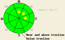
This morning, avalanche danger is LOW for all elevations and aspects. Following the onset of snowfall, pockets of MODERATE danger are expected to develop near and above treeline in wind loaded areas on N-NE-E aspects, 37 degrees and steeper in the late afternoon or evening hours. Avalanche danger is expected to continue to rise overnight into Monday. |
|
|
|
The first in a series of significant weather systems to impact the forecast area this week will move onshore today. Snow level is forecast for 5,500' to 6,000' today with a period of moderate to heavy snowfall in the afternoon or evening hours. New snow accumulations of 11 to 26 inches are expected above 7,000' over the next 36 hours. Ridgetop winds shifted from south to southwest yesterday afternoon and will remain out of the southwest through Monday. Wind speeds will continue to increase today with gusts up to 80 mph forecast for this afternoon. Expect daytime highs above 7,000' in the low to mid 30s.
Observations made yesterday at Crater Lake on Red Lake Peak (Carson Pass area) above treeline at 8,830' on a N aspect 35 degree slope indicated that a weak layer of slightly faceted crystals had formed on top of the crust that was buried on January 11. Fracture propagation tests yielded inconsistent results, but fracture propagation was shown as possible along this layer (pit profile). Observations made in Horse Canyon (near Bear Valley Ski Area) near treeline at 8,110' on a N aspect 30 degree slope showed that the snowpack contained no significant weak layers and is in very good condition to handle new snow loading (pit profile).
Avalanche concerns:
Once significant snowfall begins later today, small unstable slabs are expected to begin to form in wind loaded areas. This will occur mainly near and above treeline on N-NE-E aspects. As additional snowfall occurs during the overnight hours, these slabs will become larger and more widespread. Any areas of instability that form late today are expected to involve only the new snow. As more significant snowfall accumulates overnight, failure deeper in the snowpack may occur in areas where small faceted crystals have been observed on top of the Jan 11 crust that exists around 1 foot deep in the snowpack.
This morning, avalanche danger is LOW for all elevations and aspects. Following the onset of snowfall, pockets of MODERATE danger are expected to develop near and above treeline in wind loaded areas on N-NE-E aspects, 37 degrees and steeper in the late afternoon or evening hours. Avalanche danger is expected to continue to rise overnight into Monday.
| 0600 temperature: | 24 to 28 deg. F. |
| Max. temperature in the last 24 hours: | 35 to 40 deg. F. |
| Average wind direction during the last 24 hours: | South shifting to Southwest |
| Average wind speed during the last 24 hours: | 33 mph |
| Maximum wind gust in the last 24 hours: | 60 mph |
| New snowfall in the last 24 hours: | O inches |
| Total snow depth: | 45 to 68 inches |
For 7000-8000 ft: |
|||
| Sunday: | Sunday Night: | Monday: | |
| Weather: | Cloudy skies with a slight chance of snow in the morning, then snow in the afternoon. | Cloudy skies with snow. | Cloudy skies with snow. |
| Temperatures: | 30 to 37 deg. F. | 22 to 29 deg. F. | 27 to 34 deg. F. |
| Wind direction: | SW | S | S |
| Wind speed: | 15 to 20 mph with gusts to 35 mph. | 20 to 30 mph with gusts to 35 mph. Gusts increasing to 45 mph after midnight. | 20 to 35 mph with gusts to 55 mph. |
| Expected snowfall: | 1 to 3 in. | 3 to 7 in. | 7 to 11 in. |
For 8000-9000 ft: |
|||
| Sunday: | Sunday Night: | Monday: | |
| Weather: | Cloudy skies with a slight chance of snow in the morning, then snow in the afternoon. | Cloudy skies with snow. | Cloudy skies with snow. |
| Temperatures: | 29 to 35 deg. F. | 19 to 26 deg. F. | 27 to 33 deg. F. |
| Wind direction: | SW | S shifting to SW after midnight. | SW |
| Wind speed: | 30 to 45 mph with gusts to 65 mph. Gusts increasing to 80 mph in the afternoon. | 30 to 45 mph increasing to 40 to 50 with gusts to 80 mph after midnight. | 45 to 65 mph with gusts to 90 mph. Gusts increasing to 100 mph in the afternoon. |
| Expected snowfall: | 2 to 3 in. | 5 to 9 in. | 10 to 14 in. |


This website is owned and maintained by the non-profit arm of the Sierra Avalanche Center. Some of the content is updated by the USDA avalanche forecasters including the forecasts and some observational data. The USDA is not responsible for any advertising, fund-raising events/information, or sponsorship information, or other content not related to the forecasts and the data pertaining to the forecasts.

