In partnership with: 
|
January 28, 2010 at 7:49 am |
|
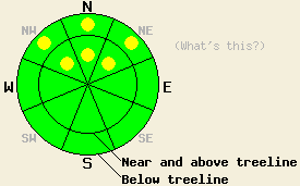
Above 8,000', pockets of MODERATE avalanche danger exist in open wind affected areas both above and below treeline on NW-N-NE aspects, 35 degrees and steeper. For all other areas, avalanche danger is LOW. |
|
|
|
Areas of clouds and fog this morning will give way to partly cloudy skies and above freezing air temperatures today in most locations. Cloud cover is expected to increase tonight ahead of a weak weather system that is expected to impact the forecast area on Friday. Ridgetop winds shifted to the northeast yesterday and increased to moderate in speed during the overnight hours. Winds speeds are expected to decrease as the day progresses.
Observations were made yesterday in a variety of locations around the forecast area. Some areas showed evidence of continued instability while other areas showed no evidence of the instability that occurred in the form of avalanches the day before. In the Mount Rose area, data was collected from two different sites of skier triggered avalanches that occurred on Tuesday. In the Pint Glass/Backside of Fireplug area on Tamarack Peak, observations indicated continued instability at 9,170' in wind affected below treeline terrain on a N aspect 38 degree slope where recent avalanche activity had occurred (photo, pit profile) (avalanche info). Observations made on the crown, flanks, and adjacent slope at the site of a skier triggered avalanche that occurred on Tuesday on Mount Rose proper at 10,170' in above treeline terrain on a SE aspect 39 degree slopes indicated that the snowpack had stabilized in this area (video, avalanche info).
Observations made on Donner Peak (Donner Summit area) revealed several crowns from natural and skier triggered avalanches in near treeline terrain on N-NE aspects steeper than 35 degrees (photo, more info). The wet snowpack that existed below 8,000' in this area on Tuesday had refrozen overnight. No evidence of continued instability was observed in this area.
Observations made near Crater Lake (Carson Pass area) adjacent to recent avalanche activity in near treeline terrain at 8,875' on a N aspect 35 degree slope indicated the presence on continued instability (photo, video). The continued instability that was observed here and in the Mount Rose area has the common themes of occurring above 8,000' in wind affected areas on NW-N-NE aspects where a slab around 1 to 1.5 feet thick sits on top of a 1 to 3 inch layer of lower density snow. Higher density old snow acts as the bed surface in these areas.
Avalanche Concerns:
Avalanche concerns for today focus on the lingering instability within the recent storm snow. The 1 to 3 inch thick weak layer of lower density snow located 1 to 1.5 feet deep in the snowpack has been slow to stabilize. Human triggered avalanches remain possible today above 8,000' in open wind affected areas both above and below treeline on NW-N-NE aspects where a higher density surface slab exists, creating an upside down snowpack.
Above 8,000', pockets of MODERATE avalanche danger exist in open wind affected areas both above and below treeline on NW-N-NE aspects, 35 degrees and steeper. For all other areas, avalanche danger is LOW.
| 0600 temperature: | 17 to 23 deg. F. |
| Max. temperature in the last 24 hours: | 28 to 32 deg. F. |
| Average wind direction during the last 24 hours: | Northeast |
| Average wind speed during the last 24 hours: | 30 mph |
| Maximum wind gust in the last 24 hours: | 50 mph |
| New snowfall in the last 24 hours: | 0 to trace inches |
| Total snow depth: | 75 to 112 inches |
For 7000-8000 ft: |
|||
| Thursday: | Thursday Night: | Friday: | |
| Weather: | Partly cloudy skies. | Partly cloudy skies in the evening, becoming mostly cloudy. | Mostly cloudy skies in the morning. Cloudy skies with a slight chance of snow in the afternoon. |
| Temperatures: | 34 to 41 deg. F. | 23 to 31 deg. F. | 34 to 41 deg. F. |
| Wind direction: | NE | SE | SW |
| Wind speed: | Around 10 mph. | Around 10 mph in the evening, becoming light. | 10 to 15 mph |
| Expected snowfall: | O in. | O in. | 0 to 2 in. |
For 8000-9000 ft: |
|||
| Thursday: | Thursday Night: | Friday: | |
| Weather: | Partly cloudy skies. | Partly cloudy skies in the evening, becoming mostly cloudy. | Mostly cloudy skies in the morning. Cloudy skies with a slight chance of snow in the afternoon. |
| Temperatures: | 33 to 40 deg. F. | 26 to 32 deg. F. | 33 to 40 deg. F. |
| Wind direction: | NE | Variable | SW |
| Wind speed: | 10 to 15 mph with gusts up to 30 mph in the morning. | Light winds | 10 to 20 mph with gusts to 35 mph in the afternoon. |
| Expected snowfall: | O in. | O in. | 0 to 2 in. |


This website is owned and maintained by the non-profit arm of the Sierra Avalanche Center. Some of the content is updated by the USDA avalanche forecasters including the forecasts and some observational data. The USDA is not responsible for any advertising, fund-raising events/information, or sponsorship information, or other content not related to the forecasts and the data pertaining to the forecasts.

