In partnership with: 
|
January 31, 2010 at 7:58 am |
|
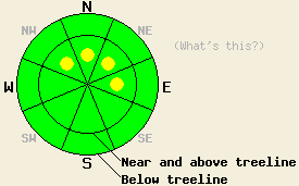
Near and above treeline, pockets of MODERATE avalanche danger remain on wind-loaded, NW-N-NE-E aspects, 37 degrees and steeper. Below treeline, avalanche danger is LOW in wind protected areas. |
|
|
|
Yesterday's weak storm system only deposited up to 2 inches of snow in some areas. Most areas only received trace accumulations of new snow. The southwest winds did transport some snow during the day. These winds started to calm down as a high-pressure ridge started building over the forecast area. This high-pressure should keep the winds light and bring mostly clear sunny skies to the forecast area today. Some clouds should start to move into the area tonight and tomorrow ahead of another weak low-pressure.
Some small, fragile, stiff, and dense wind-slabs did form on wind-loaded slopes near and above treeline by mid-day yesterday. These wind-slabs formed on top of less dense, softer snow. Skier-triggered shooting cracks occurred on Silver Peak as the newly-formed wind-slabs broke away from the snow below them. Layer bonding tests showed that weak bonds existed between these newly-formed wind-slabs and the snow below them. These tests also showed that once these bonds break the resulting fracture can travel through the snowpack along the boundary between the wind-slabs and the softer snow below them. In areas without any wind affected snow observations indicated a mostly stable snowpack.
Avalanche concern #1:
The wind-slabs that formed yesterday will remain the #1 avalanche concern today. Even though the winds did continue to load leeward slopes during the day yesterday, these wind-slabs should remain relatively shallow and small in most areas due to the lack of new snow accumulation and the decrease in wind speed overnight. The scattered nature of yesterday's snowfall should also limit this instability to pockets of terrain rather than being more widespread. Some larger wind-slabs could have formed in the most heavily wind-loaded areas near and above treeline that received more snow yesterday. Regardless of their size, human-triggering of avalanches involving these wind-slabs will remain possible today. Small avalanches can still have serious consequences. Pockets of unstable wind-slabs will most likely exist on wind-loaded, NW-N-NE-E aspects.
Near and above treeline, pockets of MODERATE avalanche danger remain on wind-loaded, NW-N-NE-E aspects, 37 degrees and steeper. Below treeline, avalanche danger is LOW in wind protected areas.
| 0600 temperature: | 19 deg. F. |
| Max. temperature in the last 24 hours: | 24 deg. F. |
| Average wind direction during the last 24 hours: | Southwest |
| Average wind speed during the last 24 hours: | 10-15 mph |
| Maximum wind gust in the last 24 hours: | 52 mph |
| New snowfall in the last 24 hours: | trace to 2 inches |
| Total snow depth: | 73-109 inches |
For 7000-8000 ft: |
|||
| Sunday: | Sunday Night: | Monday: | |
| Weather: | Sunny in the morning becoming partly cloudy this afternoon. | Partly cloudy with increasing clouds after midnight. | Mostly cloudy |
| Temperatures: | 27-35 deg. F. | 15-25 deg. F. | 29-37 deg. F. |
| Wind direction: | Southwest | Variable | Variable |
| Wind speed: | Light | Light | Light |
| Expected snowfall: | O in. | O in. | O in. |
For 8000-9000 ft: |
|||
| Sunday: | Sunday Night: | Monday: | |
| Weather: | Sunny in the morning becoming partly cloudy this afternoon. | Partly cloudy with increasing clouds after midnight. | Mostly cloudy |
| Temperatures: | 20-27 deg. F. | 14-24 deg. F. | 24-34 deg. F. |
| Wind direction: | Southwest | Southwest | Southwest |
| Wind speed: | Light | up to 10 mph | 10 mph |
| Expected snowfall: | O in. | O in. | O in. |


This website is owned and maintained by the non-profit arm of the Sierra Avalanche Center. Some of the content is updated by the USDA avalanche forecasters including the forecasts and some observational data. The USDA is not responsible for any advertising, fund-raising events/information, or sponsorship information, or other content not related to the forecasts and the data pertaining to the forecasts.

