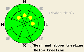
This Avalanche Advisory was published on February 1, 2010:

|
February 1, 2010 at 7:59 am |
|
Near and above treeline, pockets of MODERATE avalanche danger remain on wind-loaded, NW-N-NE-E aspects, 35 degrees and steeper. Below treeline, avalanche danger is LOW in wind protected areas. |
|
|
|
Forecast Discussion:
The high-pressure ridge has started moving east. The forecast calls for increasing cloud cover and southwest winds as a weak low-pressure system moves into the area today. The winds should remain moderate through tomorrow. This low-pressure could also bring some light snow showers to the region over the next 48 hours.
Yesterday, backcountry skiers reported 3, small, skier-triggered avalanches on Dick's Peak (in the Desolation Wilderness). These slides all occurred on steep (35 degrees), wind-loaded, northerly aspects above treeline. Recently-formed, 6-inch-thick wind-slabs comprised the slab layer in these slides. A layer of softer, lighter snow below the wind-slabs served as the weak layer. These slides measured about 50 ft across and only ran 30-40 ft down-slope (more details and photos). These skiers also reported blowing snow continuing to wind-load the northerly aspects near ridgelines during the day yesterday. Hand pits and probing with a ski pole revealed that a stiff, more dense, wind slab existed on top of lighter density snow on wind-loaded slopes in this area. Observations in the Donner Summit area also showed some weakness remains in the upper snowpack due to lingering density changes in the recent snow. On Incline Lake Peak in the Mt. Rose backcountry, snowpit tests indicated that these storm snow weaknesses have consolidated. In both the Donner Summit area and on Incline Lake peak the winds remained light during the day and did not transport much if any snow. Below treeline and on non-wind-affected slopes observations showed a more stable snowpack in all three areas with several inches of unconsolidated snow remaining on the northerly aspects.
Avalanche concern #1:
The recently-formed wind-slabs comprise the main avalanche concern, today. These wind-slabs should remain relatively shallow and small in most areas due to the lack of new snow accumulation and the limited wind speeds over the last few days. These factors should also limit this instability to pockets of terrain rather than being more widespread. Some larger wind-slabs could have formed in the most heavily wind-loaded areas near and above treeline where stronger winds have been more consistent. In many areas where these wind-slabs exist, they sit on top of a layer of lighter, weaker snow. Regardless of their size, human-triggering of avalanches involving these wind-slabs will remain possible today. Small avalanches can still have serious consequences. Pockets of unstable wind-slabs will most likely exist on wind-loaded, NW-N-NE-E aspects.
The bottom line:
Near and above treeline, pockets of MODERATE avalanche danger remain on wind-loaded, NW-N-NE-E aspects, 35 degrees and steeper. Below treeline, avalanche danger is LOW in wind protected areas.
Weather Observations from along the Sierra Crest between 8200 ft and 8800 ft:
| 0600 temperature: | 24 deg. F. |
| Max. temperature in the last 24 hours: | 29 deg. F. |
| Average wind direction during the last 24 hours: | Southwest |
| Average wind speed during the last 24 hours: | 15-20 mph |
| Maximum wind gust in the last 24 hours: | 37 mph |
| New snowfall in the last 24 hours: | O inches |
| Total snow depth: | 71-107 inches |
Two-Day Mountain Weather Forecast - Produced in partnership with the Reno NWS
For 7000-8000 ft: |
|||
| Monday: | Monday Night: | Tuesday: | |
| Weather: | Mostly cloudy with a slight chance of snow showers in the afternoon. | Cloudy with a slight chance of snow showers. | Cloudy with a chance of light snow showers in the afternoon. |
| Temperatures: | 32-38 deg. F. | 23-30 deg. F. | 31-37 deg. F. |
| Wind direction: | Southwest | South | South |
| Wind speed: | 10-15 mph | up to 10 mph | 10 mph |
| Expected snowfall: | trace in. | trace in. | trace in. |
For 8000-9000 ft: |
|||
| Monday: | Monday Night: | Tuesday: | |
| Weather: | Mostly cloudy with a slight chance of snow showers in the afternoon. | Cloudy with a slight chance of snow showers. | Cloudy with a chance of light snow showers in the afternoon. |
| Temperatures: | 26-33 deg. F. | 20-28 deg. F. | 25-32 deg. F. |
| Wind direction: | Southwest | Southwest | South |
| Wind speed: | 15-25 mph with gusts to 35 mph | 10-20 mph with gusts to 30 mph | 10-20 mph with gusts to 30 mph |
| Expected snowfall: | trace in. | trace in. | trace in. |


