In partnership with: 
|
February 4, 2010 at 7:48 am |
|
Avalanche danger is LOW for all elevations and aspects. Human triggered avalanches are unlikely but certainly not impossible today in isolated areas that have received recent wind loading. Normal caution is advised. |
|
|
|
Increasing cloud cover and scattered snow showers this afternoon will occur today as the first of two weather systems moves into the area. Snowfall intensity is expected to increase overnight tonight and continue into Saturday. Ridgetop winds are forecast to remain out of the southwest and increase in speed, becoming strong overnight tonight into Friday. Remote sensors around 8,500' are reporting air temperatures in the 20s this morning. Air temperatures are expected to rise to the upper 20s to low 30s today.
Observations made yesterday on Silver Peak (Pole Creek area) on N-NE aspects between 7,200' and 8,100' in near treeline and below treeline terrain revealed no significant evidence of instability. A shallow wind slab 4 to 6 inches thick was present in wind loaded areas, but this slab did not show much evidence of fracture propagation propensity. Ski cuts on steep wind loaded convex slopes produced only very minor cracking in isolated areas. Snowpit data collected in near treeline wind loaded terrain at 7,930' on a N aspect 38 degree slope further supported the absence of instability (pit profile, video).
Avalanche Concerns:
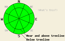
Human triggered avalanche activity in unlikely but not impossible today in recently wind loaded areas. Wind slabs that formed yesterday morning and showed very little to no evidence of instability yesterday are expected to have become increasingly stable since that time. Ridgetop winds have been strong enough to move snow over the past 24 hours, but very little snow has been available for wind transport. Any areas of instability that exist today will most likely be found near and above treeline on NW-N-NE-E aspects. Keep in mind the difference between the terms unlikely and impossible. Employ good travel techniques in the backcountry today in order to minimize risk.
Avalanche danger is LOW for all elevations and aspects. Human triggered avalanches are unlikely but certainly not impossible today in isolated areas that have received recent wind loading. Normal caution is advised.
| 0600 temperature: | 22 to 27 deg. F. |
| Max. temperature in the last 24 hours: | 27 to 34 deg. F. |
| Average wind direction during the last 24 hours: | Southwest |
| Average wind speed during the last 24 hours: | 37 mph |
| Maximum wind gust in the last 24 hours: | 63 mph |
| New snowfall in the last 24 hours: | O inches |
| Total snow depth: | 69 to 107 inches |
For 7000-8000 ft: |
|||
| Thursday: | Thursday Night: | Friday: | |
| Weather: | Cloudy skies with isolated snow showers in the afternoon. | Cloudy skies with a chance of snow in the evening. Snow after midnight. | Cloudy skies with snow. |
| Temperatures: | 31 to 36 deg. F. | 19 to 26 deg. F. | 28 to 34 deg. F. |
| Wind direction: | SW | S | S |
| Wind speed: | 10 to 15 mph with gusts to 35 mph in the afternoon. | 15 to 25 mph with gusts to 40 mph. | 15 to 25 mph with gusts to 40 mph. |
| Expected snowfall: | Trace in. | 2 to 4 in. | 2 to 5 in. |
For 8000-9000 ft: |
|||
| Thursday: | Thursday Night: | Friday: | |
| Weather: | Cloudy skies with isolated snow showers in the afternoon. | Cloudy skies with a chance of snow in the evening. Snow after midnight. | Cloudy skies with snow. |
| Temperatures: | 23 to 33 deg. F. | 17 to 24 deg. F. | 22 to 30 deg. F. |
| Wind direction: | SW | SW | S |
| Wind speed: | 10 to 15 mph with gusts to 25 mph. Winds increasing to 15 to 25 mph with gusts to 40 mph in the afternoon. | 30 to 50 mph with gusts to 70 mph. | 25 to 45 mph with gusts to 70 mph. Gusts decreasing to 55 mph in the afternoon. |
| Expected snowfall: | Trace in. | 2 to 5 in. | 2 to 6 in. |


This website is owned and maintained by the non-profit arm of the Sierra Avalanche Center. Some of the content is updated by the USDA avalanche forecasters including the forecasts and some observational data. The USDA is not responsible for any advertising, fund-raising events/information, or sponsorship information, or other content not related to the forecasts and the data pertaining to the forecasts.

