In partnership with: 
|
February 7, 2010 at 8:00 am |
|
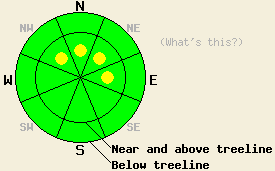
Near and above treeline pockets of MODERATE avalanche danger remain on NW-N-NE-E aspects steeper than 35 degrees. Below treeline the avalanche danger is LOW. |
|
|
|
Only 2-5 inches of new snow fell over the last 24 hrs along the Sierra Crest. East of Lake Tahoe in the Carson Range 4-8 inches of new snow accumulated. Areas south and east of the lake received the most new snow. The winds shifted to the north and east and the snow showers started to taper off last night as this system began to move out of the area. Snow showers should become more isolated and less frequent today. The winds should continue to shift to the north and east as a small high-pressure ridge impacts the forecast area later today through tomorrow.
Yesterday observations in the Mt. Rose area, in the Donner Summit area, and in the Bear Valley area showed a strengthening trend in the snowpack. Ski-cuts and dropping oven-sized cornices onto wind-loaded, N-NE-facing slopes near and above treeline along the east ridge of Tamarack Peak in the Mt. Rose area and along the ridgeline above Underwood Bowl in the Bear Valley area did not cause any failures in the snowpack. Other steep test slopes below treeline in these areas also did not react to the weight of a person on the slope. On Andesite Ridge in the Donner Summit area as well as in the Bear Valley and Mt. Rose areas, layer bonding tests showed the moderate force could still break the lingering weaknesses within the new snow. However, most tests in these areas also showed that if these layers do break, it is becoming more difficult for that fracture to propagate through the snowpack.
Avalanche Concerns:
Continued bonding within the recent snow, decreased winds, and light snow accumulation over the last 24 hours should make most avalanche activity unlikely today. However, some pockets of sensitive wind-slabs where human-triggered avalanches remain possible should still exist on wind-loaded slopes near and above treeline. In the Carson Range east of Lake Tahoe more new snow over the last 24 hrs should allow these wind-slabs to be larger and more widespread. In these areas the wind-slabs will be more fragile. Tender cornices that will break due to the additional weight of a person will remain perched above wind-loaded slopes today. Use clues like drifted snow, cornices, ripples, and other wind-created textures to determine where wind-loading has occurred. Use normal caution when traveling in the backcountry.
Near and above treeline pockets of MODERATE avalanche danger remain on NW-N-NE-E aspects steeper than 35 degrees. Below treeline the avalanche danger is LOW.
| 0600 temperature: | 22 deg. F. |
| Max. temperature in the last 24 hours: | 27 deg. F. |
| Average wind direction during the last 24 hours: | Southwest shifting to the Northeast last night |
| Average wind speed during the last 24 hours: | Southwest: 10-20 mph | Northeast: 5-10 mph |
| Maximum wind gust in the last 24 hours: | 55 mph |
| New snowfall in the last 24 hours: | Sierra Crest: 2-5 inches | Carson Range east of the Lake: 4-8 inches |
| Total snow depth: | 76-114 inches |
For 7000-8000 ft: |
|||
| Sunday: | Sunday Night: | Monday: | |
| Weather: | Mostly cloudy with isolated snow showers. | Partly cloudy | Mostly cloudy with a slight chance for isolated snow showers. |
| Temperatures: | 27-32 deg. F. | 18-23 deg. F. | 28-33 deg. F. |
| Wind direction: | North | North shifting to the east | East |
| Wind speed: | 10 mph with gusts to 25 mph | 10 mph | 10 mph becoming light in the afternoon |
| Expected snowfall: | trace to .1 in. | O in. | trace to .5 in. |
For 8000-9000 ft: |
|||
| Sunday: | Sunday Night: | Monday: | |
| Weather: | Mostly cloudy with isolated snow showers. | Partly cloudy | Mostly cloudy with a slight chance for isolated snow showers. |
| Temperatures: | 22-29 deg. F. | 15-20 deg. F. | 23-30 deg. F. |
| Wind direction: | North | Northeast shifting to the east | East |
| Wind speed: | 10-20 mph with gusts to 40 mph | 10-20 mph decreasing to 10 mph after midnight | 10 mph becoming light in the afternoon |
| Expected snowfall: | trace to .1 in. | O in. | trace to .5 in. |


This website is owned and maintained by the non-profit arm of the Sierra Avalanche Center. Some of the content is updated by the USDA avalanche forecasters including the forecasts and some observational data. The USDA is not responsible for any advertising, fund-raising events/information, or sponsorship information, or other content not related to the forecasts and the data pertaining to the forecasts.

