In partnership with: 
|
February 9, 2010 at 8:04 am |
|
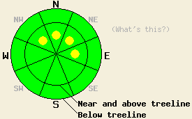
Near and above treeline, pockets of MODERATE avalanche danger will form today in wind loaded areas on NW-N-NE-E aspects 35 degrees and steeper. Below treeline, avalanche danger is LOW in wind sheltered areas. |
|
|
|
A weak weather system is moving through the forecast area this morning. Off and on snow showers with spotty areas of significant accumulation are expected today with most of the new snow accumulating in areas south of Hwy 50. Around 0.5 inches of new snow fell across the forecast area last night with an additional 1 to 3 inches of new snow expected to accumulate today, mainly during the morning hours. Southwest ridgetop winds increased to moderate in speed late yesterday afternoon and continued overnight. Moderate south winds are expected to occur this morning before shifting to the east and becoming light this afternoon. Expect air temperatures at the 8,000' level to rise from the low 20s this morning to the mid to upper 20s as the day progresses.
Day to day snowpack observations from around the forecast area have shown a trend of snowpack stabilization since the last major period of snowpack instability occurred Friday morning (more info). Within this overall trend of stabilization, a few small skier triggered avalanche events have been reported. On Saturday, several small skier triggered point release loose snow type avalanches just a few inches deep measuring 10' wide by 25' long occurred on Red Lake Peak (Carson Pass area) in above treeline terrain on a NE aspect 38 degree slope at 9,000'. Incomplete information was received of a skier triggered avalanche occurring Sunday in the entrance to the Cross Couloir on Mt. Tallac (Desolation Wilderness area). This is very steep and complex terrain above treeline around 9,400', generally NE aspect with micro terrain features that cover N-NE-E-SE-S aspects. A third skier triggered point release wet loose snow type avalanche occurred yesterday on Mt. Reba near Bear Valley in above treeline terrain on a SW aspect at 8,000' on a 35 degree slope. The avalanche measured a few inches deep, 40' wide and 350' long. This avalanche was triggered at a rock band which would have increased solar radiation and heat to the surrounding snowpack over the past two days. The moving snow was able to entrain recent storm snow as it moved down the slope, increasing the mass of moving snow (photos).
Avalanche Concerns:
Avalanche concerns for today focus on new snowfall. Snow accumulations will be spotty today allowing some areas to receive up to 3 inches of new snow while other areas receive only a trace of new snow. In areas that receive the upper end of forecast snowfall amounts, small slabs will form in wind loaded areas. This will mainly occur near and above treeline on NW-N-NE-E aspects in areas below cornice features. Stabilizing conditions over the past few days should keep any snowpack instability on northerly and easterly aspects limited to the new snow only, with any failure in old snow layers occurring only as very isolated events. Cloud cover through the day today should keep any warming type snow surface instabilities from occurring today on southerly and westerly aspects.
Near and above treeline, pockets of MODERATE avalanche danger will form today in wind loaded areas on NW-N-NE-E aspects 35 degrees and steeper. Below treeline, avalanche danger is LOW in wind sheltered areas.
| 0600 temperature: | 21 to 27 deg. F. |
| Max. temperature in the last 24 hours: | 30 to 34 deg. F. |
| Average wind direction during the last 24 hours: | Southwest |
| Average wind speed during the last 24 hours: | 20 mph |
| Maximum wind gust in the last 24 hours: | 35 mph |
| New snowfall in the last 24 hours: | 0.5 inches |
| Total snow depth: | 73 to 112 inches |
For 7000-8000 ft: |
|||
| Tuesday: | Tuesday Night: | Wednesday: | |
| Weather: | Cloudy skies with numerous snow showers. | Mostly cloudy skies with scattered snow showers in the evening. Isolated snow showers after midnight. | Partly cloudy skies. |
| Temperatures: | 26 to 31 deg. F. | 17 to 22 deg. F. | 31 to 36 deg. F. |
| Wind direction: | S shifting to E | NE | E |
| Wind speed: | 10 to 15 mph | 10 to 15 mph with gusts to 25 mph after midnight. | 10 to 15 mph early becoming light. |
| Expected snowfall: | 1 to 2 in. | trace in. | O in. |
For 8000-9000 ft: |
|||
| Tuesday: | Tuesday Night: | Wednesday: | |
| Weather: | Cloudy skies with numerous snow showers. | Cloudy skies with scattered snow showers in the evening. Isolated snow showers after midnight. | Partly cloudy skies. |
| Temperatures: | 22 to 28 deg. F. | 15 to 20 deg. F. | 27 to 32 deg. F. |
| Wind direction: | S shifting to E | NE | E |
| Wind speed: | 10 to 20 mph with gusts to 25 mph. | 15 to 25 mph with gusts to 35 mph. | 10 to 20 mph becoming light by the afternoon. |
| Expected snowfall: | 1 to 3 in. | Up to 1 in. | O in. |


This website is owned and maintained by the non-profit arm of the Sierra Avalanche Center. Some of the content is updated by the USDA avalanche forecasters including the forecasts and some observational data. The USDA is not responsible for any advertising, fund-raising events/information, or sponsorship information, or other content not related to the forecasts and the data pertaining to the forecasts.

