In partnership with: 
|
February 15, 2010 at 7:43 am |
|
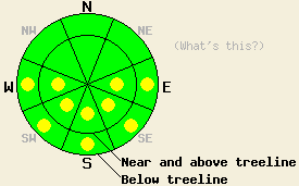
Early this morning, avalanche danger is LOW for all elevations and aspects. Pockets of MODERATE danger will form at all elevations on E-SE-S-SW-W aspects 35 degrees and steeper in response to daytime warming. |
|
|
|
High pressure remains in place over the forecast area. High clouds and plenty of sun are expected today. Light winds and air temperatures in the mid 40s to low 50s are forecast for today in areas above 7,000'. A weak weather system passing to the north of the area will bring a slight chance of showers on Tuesday.
Observations made yesterday on Silver Peak (Pole Creek area) continued to show melt freeze conditions on all aspects. Evidence of roller ball activity was widespread, but appeared to have mostly occurred on previous days. Around mid day, 2 to 4 inches of wet snow was noted on E-SE-S aspects up to the summit at 8,400', likely extending higher on neighboring peaks. A layer of wet snow at the surface containing plenty of free water was noted on top of cold, drier snow below. On northerly aspects, a surface melt freeze crust up to 1 inch thick was observed up to 8,000'. No new avalanche activity has been reported since Friday.
Overnight air temperatures dropped into the mid 20s at the 9,600' level and to near freezing at the 8,600' level. Air temperatures below 8,300' remained in the mid 30s. Above 9,000' and solid overnight refreeze of the snowpack is expected to have occurred. Below 8,500', a weaker overnight refreeze of the snowpack will have occurred due to radiational cooling despite above freezing air temperatures.
Avalanche Concerns:
Avalanche concerns for today focus on wet snow on E-SE-S-SW-W aspects at all elevations. With less wind and warmer air temperatures today than yesterday, several inches of wet surface snow are expected to form today on southerly aspects. This is expected to lead to pockets of instability, especially near exposed rocks and cliff bands where radiating heat from these features will have slowed overnight refreeze and will add additional heat to the snowpack during the day.
Early this morning, avalanche danger is LOW for all elevations and aspects. Pockets of MODERATE danger will form at all elevations on E-SE-S-SW-W aspects 35 degrees and steeper in response to daytime warming.
| 0600 temperature: | 31 to 34 deg. F. |
| Max. temperature in the last 24 hours: | 40 to 48 deg. F. |
| Average wind direction during the last 24 hours: | West |
| Average wind speed during the last 24 hours: | 20 mph |
| Maximum wind gust in the last 24 hours: | 38 mph |
| New snowfall in the last 24 hours: | O inches |
| Total snow depth: | 68 to 106 inches |
For 7000-8000 ft: |
|||
| Monday: | Monday Night: | Tuesday: | |
| Weather: | High clouds decreasing in the afternoon. | Mostly cloudy skies. | Mostly cloudy skies with a slight chance of rain/snow showers. |
| Temperatures: | 48 to 54 deg. F. | 23 to 29 deg. F. | 40 to 47 deg. F. |
| Wind direction: | W | Variable | Variable |
| Wind speed: | Light winds | Light winds | Light winds |
| Expected snowfall: | O in. | O in. | 0 to trace in. |
For 8000-9000 ft: |
|||
| Monday: | Monday Night: | Tuesday: | |
| Weather: | High clouds decreasing in the afternoon. | Mostly cloudy skies. | Mostly cloudy skies with a slight chance of snow showers. |
| Temperatures: | 42 to 50 deg. F. | 18 to 25 deg. F. | 39 to 45 deg. F. |
| Wind direction: | W | W | W |
| Wind speed: | Up to 10 mph becoming light. | Light winds | Light winds |
| Expected snowfall: | O in. | O in. | 0 to trace in. |


This website is owned and maintained by the non-profit arm of the Sierra Avalanche Center. Some of the content is updated by the USDA avalanche forecasters including the forecasts and some observational data. The USDA is not responsible for any advertising, fund-raising events/information, or sponsorship information, or other content not related to the forecasts and the data pertaining to the forecasts.

