In partnership with: 
|
February 22, 2010 at 7:59 am |
|
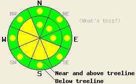
Near and above treeline, avalanche danger is MODERATE in wind loaded areas on SE-S-SW-W-NW aspects on slopes 35 degrees and steeper. Pockets of MODERATE danger may linger on N-NE-E aspects 35 degrees and steeper. Below treeline, pockets of MODERATE danger exist in open wind loaded areas on all aspects, 35 degree and steeper. Avalanche danger in LOW in wind sheltered areas. |
|
|
|
A short lived break in the weather will occur today. Clearing skies and northeast flow overnight have dropped air temperatures down into the teens and single digits for all areas above 6,000'. 24 hour new snow amounts range from a trace to 4 inches. Storm totals from the past 48 hours vary significantly from one location to another. Along the Sierra Crest, storm totals range from 3 to 8 inches. In the Carson Range, storm totals range from 5 to 14 inches. Ridgetop winds shifted to the northeast and east overnight and have been strong enough to move snow. East winds with gusts 40 to 65 mph are expected to continue into tonight.
Observations made yesterday showed significant variation in snowpack stability from one area to another. On North Maggies Peak (Emerald Bay area) a small skier triggered avalanche occurred below treeline at 8,350' on a N aspect 38 degree slope. Snowpack failure occurred at the old/new snow interface. The crown measured 6 to 12 inches deep and the avalanche measured 15' wide and ran 200' down slope (photo, more info). On Jake's Peak (West Shore Tahoe area) evidence of instability was limited to a N aspect near treeline 40 degree slope that had experienced more wind exposure and slab formation than other slopes within the same area. Fracture propagation tests indicated that fracture propagation of a 1 foot deep slab of wind loaded snow was likely on this particular slope (video, photos, more info). On Tamarack Peak (Mount Rose area) where around 11 inches of new snow existed yesterday afternoon, no evidence of instability was observed beyond the presence of recent new snow (pit profile). Winds had remained light in this area with no significant slab formation observed on N-NE-E aspects in wind exposed areas both near treeline and below treeline between 8,600' and 9,900'. On Echo Peak (Echo Summit area) significant wind loading onto NE aspects was reported to occur during the afternoon hours (more info). An unconfirmed secondhand report of a skier triggered avalanche was received from this area.
Avalanche Concerns:
Avalanche concerns for today continue to focus on wind affected new snow. Wide variances in new snowfall amounts and snowpack instability from one location to another are expected today, similar to yesterday. Wind speeds have varied from one area to another creating slabs in some areas and no slab formation in other areas. Concern for lingering wind slabs exists on all aspects today due to SW winds yesterday afternoon and NE to E winds last night and today. In both cases, winds were strong enough to move snow. Peaking E winds this morning may scour NE-E slopes back down to the old snow surface in some above treeline areas. This redistribution of snow will allow for pockets of instability to exist on all aspects and at all elevations where recent wind loading has occurred.
Near and above treeline, avalanche danger is MODERATE in wind loaded areas on SE-S-SW-W-NW aspects on slopes 35 degrees and steeper. Pockets of MODERATE danger may linger on N-NE-E aspects 35 degrees and steeper. Below treeline, pockets of MODERATE danger exist in open wind loaded areas on all aspects, 35 degree and steeper. Avalanche danger in LOW in wind sheltered areas.
| 0600 temperature: | 9 to 14 deg. F. |
| Max. temperature in the last 24 hours: | 20 to 27 deg. F. |
| Average wind direction during the last 24 hours: | Southwest shifting to East. |
| Average wind speed during the last 24 hours: | 25 mph |
| Maximum wind gust in the last 24 hours: | 62 mph |
| New snowfall in the last 24 hours: | trace to 4 inches |
| Total snow depth: | 68 to 106 inches |
For 7000-8000 ft: |
|||
| Monday: | Monday Night: | Tuesday: | |
| Weather: | Partly cloudy skies in the morning, then clearing. | Partly cloudy skies. | Mostly cloudy skies with a slight chance of snow in the morning. Cloudy skies with a chance of snow in the afternoon. |
| Temperatures: | 23 to 30 deg. F. | 10 to 17 deg. F. | 27 to 34 deg. F. |
| Wind direction: | E | E | S |
| Wind speed: | 10 to 15 mph with gusts to 30 mph. | 10 to 15 mph with gusts to 30 mph. | 10 to 15 mph with gusts up to 35 mph in the afternoon. |
| Expected snowfall: | O in. | O in. | 0 to trace in. |
For 8000-9000 ft: |
|||
| Monday: | Monday Night: | Tuesday: | |
| Weather: | Partly cloudy skies in the morning, then clearing. | Partly cloudy skies. | Mostly cloudy skies with a slight chance of snow in the morning. Cloudy skies with a chance of snow in the afternoon. |
| Temperatures: | 20 to 27 deg. F. | 12 to 19 deg. F. | 25 to 32 deg. F. |
| Wind direction: | E | E | S |
| Wind speed: | 30 to 40 mph with gusts to 65 mph inthe morning. 15 to 25 mph with gusts to 40 mph in the afternoon. | 15 to 25 mph with gusts to 40 mph. | 10 to 20 mph with gusts to 35 mph. |
| Expected snowfall: | O in. | O in. | 0 to trace in. |


This website is owned and maintained by the non-profit arm of the Sierra Avalanche Center. Some of the content is updated by the USDA avalanche forecasters including the forecasts and some observational data. The USDA is not responsible for any advertising, fund-raising events/information, or sponsorship information, or other content not related to the forecasts and the data pertaining to the forecasts.

