In partnership with: 
|
February 26, 2010 at 8:01 am |
|
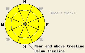
MODERATE avalanche danger exists on all slopes steeper than 35 degrees today. The avalanche danger will increase to CONSIDERABLE tonight on wind-loaded NW-N-NE-E-SE slopes steeper than 35 degrees both above and below treeline as more snow and wind impact the forecast area. |
|
|
|
Winds, temperatures, and cloud cover have all increased as a low pressure approaches northern CA. The forecast calls for the storm to impact the forecast area later today bringing even stronger winds and heavy, wet snow to the mountains. Snow levels should start around 7000 ft. today before dropping to between 5000 and 5500 ft by tomorrow. The forecast calls for snow and rain to start this afternoon with the heaviest period of precipitation between 5 pm and midnight tonight. The forecast calls for 6-12 inches of new, heavy snow overnight and for wind gusts over the ridge tops to exceed 100 mph this afternoon and tonight. Snow should start to taper off and the winds should decrease tomorrow afternoon and evening as this storm moves out of the area.
Yesterday, observations in the Donner Summit area showed a thick, heavy, hard snow layer with a few inches of soft snow on top of it on the surface on most aspects. This hard layer would only support a person if she stayed on her skis or snowboard. Once she stepped off the skis or board, she would sink into the snow almost down to the Feb. 19th snow surface. Ski cuts and dropping oven sized pieces of cornice onto wind-loaded test slopes did not result in any new avalanche activity yesterday. Hand pits, probing with a ski pole, formal snowpit observations showed that a soft, lighter layer of new snow still exists below the hard, heavy snow and that some storm snow weaknesses remain within the new snow below the hard, heavy layer. Snowpit observations also showed that an old crust with a thin layer of weak, sugary crystals below it exists at base of the new snow. Layer-bonding tests did indicate that the bonds within the new snow have started to gain strength; however, the bonding between old crust and the new snow remains weak. Tests also showed that if these bonds break, that fracture can propagate through the snowpack along the old crust layer.
These observations continue to indicate variability in the the strength and distribution of weak layers at the base of the new snow. This variation in layer characteristics means more variability in the snowpack stability from area to area and slope to slope. Careful snowpack evaluation and terrain choices are a must for today.
Avalanche Concern #1:
Avalanche activity due to poor bonding between the old weak layers and the new snow will remain possible today. Observations indicate that the weak old snow persists more on the northerly aspects. These old weak layers range from thin crusts with weak, sugary snow underneath them to isolated areas of surface hoar to old unconsolidated snow. Near and above treeline, thick, heavy, hard wind slabs sit on top of these layers on the wind-loaded slopes. Below treeline, firm, heavy new snow sits on top of these layers. Causing a failure in these layers today will be more difficult than it was on the previous two days. However, the right trigger in the right spot (click here for a description of likely trigger points) could still overload the older weak layers mentioned above on both wind-loaded and non-wind-loaded slopes resulting in avalanche activity. These avalanches can propagate long distances on along some of those weak layers resulting in large dangerous avalanches. The location, strength, and distribution of these weak layers varies greatly across the forecast area. Digging quick hand pits down to the older snow and testing the bonding between the older snow surfaces and the more recent snow can help determine where these weaknesses exist. As more snow accumulates tonight these types of avalanches will become easier to trigger once again.
Avalanche Concern #2:
New snow and wind starting this afternoon will start to build new wind slabs on wind-loaded slopes. These slabs should remain small for most of the day due to a lack of new snow accumulation. Small, human-triggered avalanches involving these new wind slabs may become possible later in the day in areas that receive the high end of forecasted snow today. These wind slabs will quickly grow larger and more widespread as the snowfall rates and winds increase late this afternoon and evening. Natural avalanche activity involving these new wind slabs will become possible overnight tonight if the region receives the predicted snow amounts. These avalanches could step down to older weak layers at the base of the recent snow resulting in large destructive slides.
MODERATE avalanche danger exists on all slopes steeper than 35 degrees today. The avalanche danger will increase to CONSIDERABLE tonight on wind-loaded NW-N-NE-E-SE slopes steeper than 35 degrees both above and below treeline as more snow and wind impact the forecast area.
| 0600 temperature: | 27-32 deg. F. |
| Max. temperature in the last 24 hours: | 29-38 deg. F. |
| Average wind direction during the last 24 hours: | Southwest |
| Average wind speed during the last 24 hours: | 25-30 mph |
| Maximum wind gust in the last 24 hours: | 73 mph |
| New snowfall in the last 24 hours: | O inches |
| Total snow depth: | 77-115 inches |
For 7000-8000 ft: |
|||
| Friday: | Friday Night: | Saturday: | |
| Weather: | Snow starting after 10 am and becoming more widespread and heavier this afternoon.Snow levels around 7000 ft. | Snow. | Snow in the morning then tapering off in the late afternoon. |
| Temperatures: | 30-35 deg. F. | 18-25 deg. F. | 25-30 deg. F. |
| Wind direction: | South | South | Southwest |
| Wind speed: | 10-20 mph with gusts to 45 mph increasing to 30-40 mph with gusts to 70 mph in the afternoon | 30-40 mph with gusts to 65 mph | 10-15 mph with gusts to 25 mph |
| Expected snowfall: | up to 3 in. | 6-10 in. | 2-3 in. |
For 8000-9000 ft: |
|||
| Friday: | Friday Night: | Saturday: | |
| Weather: | Snow starting after 10 am and becoming more widespread and heavier this afternoon. | Snow. | Snow in the morning then tapering off in the late afternoon. |
| Temperatures: | 28-32 deg. F. | 16-23 deg. F. | 20-25 deg. F. |
| Wind direction: | South | South shifting to the southwest after midnight | Southwest |
| Wind speed: | 30-40 mph with gusts to 75 mph increasing to 50-70 mph with gusts to 110 mph in the afternoon | 30-50 mph with gusts to 105 mph decreasing to 20-30 mph with gusts to 80 mph after midnight | 10-20 mph with gusts to 35 mph |
| Expected snowfall: | up to 4 in. | 6-12 in. | 3-5 in. |


This website is owned and maintained by the non-profit arm of the Sierra Avalanche Center. Some of the content is updated by the USDA avalanche forecasters including the forecasts and some observational data. The USDA is not responsible for any advertising, fund-raising events/information, or sponsorship information, or other content not related to the forecasts and the data pertaining to the forecasts.

