In partnership with: 
|
March 1, 2010 at 8:01 am |
|
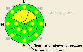
Near and above treeline, avalanche danger is MODERATE on NW-N-NE aspects, 35 degrees and steeper due to deep slab instability. Avalanche danger is LOW with pockets of MODERATE danger due to warming instability involving the recent new snow at all elevations on E-SE-S-SW-W aspects and mid to lower elevation NW-N-NE aspects, on slopes 35 degrees and steeper. Large destructive avalanche remain possible. |
|
|
|
Transitioning weather today will bring increasing high clouds, near to above freezing air temperatures, and light to moderate south winds. An approaching weather system is expected to bring light snowfall to the forecast area late tonight and tomorrow. Ridgetop winds have shifted from east to south this morning ahead of the approaching weather system. Remote sensors above 7,000' are reporting air temperatures in the mid 20s to low 30s this morning.
Yesterday morning, a large skier triggered deep slab avalanche occurred on Ralston Peak (Echo Summit area). This avalanche occurred above treeline at 8,600' on a NW aspect 40 degree slope. The skier triggered the avalanche on a convex portion of the slope with exposed rocks where the slab was 1 foot deep. The avalanche then propagated 500' wide with a crown height up to 4' deep. The failure layer was identified as a 2 cm thick 4 finger hard layer of grauple and rounded crystals sandwiched between the pencil hard February 19 bed surface and 1 finger hard old snow slab above. Three other skiers had successfully descended this slope a few hundred feet away on a lower angle portion of the slope without the complex terrain features prior to the avalanche occurrence (photos, more info). Observations made mid day yesterday at Grouse Rocks (Greater Blackwood Canyon area) yielded no signs of instability above and below treeline on NE-E aspects between 8,500' and 7,200'. Heavy skier traffic in the area tested nearly all available trigger points with no slab or loose snow instability observed in avalanche start zones with slope angles between 30 and 45 degrees (more info). Yesterday afternoon, a skier triggered wet loose snow avalanche occurred below Cup Lake near Ralston Peak. This avalanche occurred above treeline on a SE aspect at 8,500' on a 40 degree slope. This avalanche involved only the top few inches of the snowpack wet from solar radiation and moved slowly 1,000' down slope (photos, more info).
Avalanche Concern #1: Deep slab instability
As the recent storm snow continues to gain strength, the area of greatest relative weakness is moving deeper into the snowpack down to the level of the Feb 19 layer. Observations over the past week have noted that this layer interface has been slow to stabilize in some areas. The exact characteristics of the Feb 19 layer vary from one location to another, but a significant increase in snow hardness (crust or dense snow) with occasional persistent crystals types such as grauple and partially destroyed surface hoar have been observed at this layer on NW-N-NE aspects near and above treeline. This layer is generally buried 1 to 4 feet deep in the snowpack on northerly aspects. Large destructive human triggered avalanches remain possible today, especially in complex terrain where exposed rocks will bring the weak layer closer to the surface making for easier human triggered snowpack failure.
Avalanche Concern #2: Surface wet snow instability
Despite increasing cloud cover today, warming instability of the recent storm snow remains a concern. This will mainly occur below 10,000' on E-SE-S-SW-W aspects and on mid to lower elevation NW-N-NE aspects. Large open areas on E-SE-S aspects remain the most suspect. This snowpack instability is expected to affect only to top few inches of the snowpack and occur as point release avalanche activity rather than slab avalanche activity.
Near and above treeline, avalanche danger is MODERATE on NW-N-NE aspects, 35 degrees and steeper due to deep slab instability. Avalanche danger is LOW with pockets of MODERATE danger due to warming instability involving the recent new snow at all elevations on E-SE-S-SW-W aspects and mid to lower elevation NW-N-NE aspects, on slopes 35 degrees and steeper. Large destructive avalanche remain possible.
| 0600 temperature: | 23 to 33 deg. F. |
| Max. temperature in the last 24 hours: | 34 to 38 deg. F. |
| Average wind direction during the last 24 hours: | East shifting to south |
| Average wind speed during the last 24 hours: | 15 mph |
| Maximum wind gust in the last 24 hours: | 34 mph |
| New snowfall in the last 24 hours: | O inches |
| Total snow depth: | 83 to 118 inches |
For 7000-8000 ft: |
|||
| Monday: | Monday Night: | Tuesday: | |
| Weather: | Partly cloudy skies in the morning, becoming mostly cloudy. | Cloudy skies with a slight chance of snow after midnight. | Cloudy skies with a chance of snow in the morning. Snow in the afternoon. |
| Temperatures: | 33 to 40 deg. F. | 25 to 28 deg. F. | 25 to 30 deg. F. |
| Wind direction: | S | S | S |
| Wind speed: | Up to 10 mph. | 10 to 15 mph with gusts to 30 mph. Winds increasing to 15 to 25 mph with gusts to 40 mph after midnight. | 15 to 25 mph with gusts to 40 mph. Gusts increasing to 55 mph in the afternoon. |
| Expected snowfall: | O in. | 0 to trace in. | 1 to 4 in. |
For 8000-9000 ft: |
|||
| Monday: | Monday Night: | Tuesday: | |
| Weather: | Partly cloudy skies in the morning, becoming mostly cloudy. | Cloudy skies with a slight chance of snow after midnight. | Cloudy skies with a chance of snow in the morning. Snow in the afternoon. |
| Temperatures: | 32 to 39 deg. F. | 20 to 27 deg. F. | 22 to 28 deg. F. |
| Wind direction: | S | S | S |
| Wind speed: | Up to 10 mph with gusts to 25 mph in the afternoon. | 15 to 25 mph with gusts to 40 mph. Winds increasing to 25 to 35 mph with gusts to 70 mph after midnight. | 20 to 35 mph with gusts to 75 mph. |
| Expected snowfall: | O in. | 0 to trace in. | 1 to 4 in. |


This website is owned and maintained by the non-profit arm of the Sierra Avalanche Center. Some of the content is updated by the USDA avalanche forecasters including the forecasts and some observational data. The USDA is not responsible for any advertising, fund-raising events/information, or sponsorship information, or other content not related to the forecasts and the data pertaining to the forecasts.

