In partnership with: 
|
March 3, 2010 at 8:00 am |
|
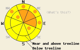
Near and above treeline during the day today on slopes 35 degrees and steeper, the avalanche danger will rise to CONSIDERABLE on N-NE-E aspects with pockets of CONSIDERABLE on the NW and SE aspects. Below treeline pockets of CONSIDERABLE danger will also develop on the NW-N-NE-E aspects on slopes steeper than 35 degrees. In all other areas the avalanche danger is MODERATE. Large destructive avalanches remain possible. |
|
|
|
4-6 inches of snow has fallen during the last 24 hrs across most of the forecast area. Another stronger, colder, low pressure system should move into central CA today. This system will bring colder temperatures, wind, and snow to the forecast area. Snowfall should start this morning and continue through tonight. The forecast calls for 6-14 in. above 7000' and 10-16 in. above 8000'. The Sierra Crest above 8000' could see as much as 20 in. over the next 24 hrs. The heaviest snowfall should occur during the day today with snowfall rates approaching 2 in/hr. This storm should start to exit the area tonight leaving cold, dry air in its wake for tomorrow.
Observations from Jake's Peak and from Frog Lake (near Carson Pass) showed that the strong southwest winds transported snow and started to create soft wind slabs on the N-NE aspects by mid afternoon yesterday. On a NE-facing, 38-degree, wind-loaded test slope above Frog Lake a small soft slab (2-6 in deep, 10 ft wide, and 15 ft long) released in response to the added weight of a skier (photo). Ski cuts did not cause any cracking or failures on wind-loaded test slopes in the Jake's Peak area. In both of these areas ski cuts did trigger sluffs in the new snow. Snowpits near and below treeline on NE and N aspects in the Frog Lake area showed that the Feb. 19th interface continues to gain strength in this area. A thin crust with a thin layer of softer, weaker snow below it comprises the Feb 19th interface in this area (photo). Layer bonding tests did indicate that with enough force the bonds at this interface could still break.
Avalanche Concern #1: Wind Slabs
Today, the new wind slabs that started to form yesterday will grow in size and distribution as more snow and wind impact the forecast area. Human-triggered avalanches involving these new wind slabs will become probable today on wind-loaded slopes near and above treeline. By this afternoon, natural avalanche activity due to failure of the wind slabs and the cornices that form above them will become possible. These avalanches could step down to the Feb. 19th interface resulting in large destructive slides. The wind-loaded NW-N-NE-E aspects and cross-loaded SE and NW aspects near and above treeline are the most likely locations for fragile wind slabs and cornices to form today.
Avalanche Concern #2: Deep slab instability
Human-triggered avalanche activity due to poor bonding between the Feb 19th snow surfaces and the snow above will remain possible today. This interface has barely strengthened to the point where it can support the current snowpack. As more snow quickly accumulates today, it could overload this interface, and these types of avalanches could become more widespread and easier to trigger once again. Areas of complex terrain near and above treeline on northerly aspects hold the most potential for triggering these large, deep avalanches. However, by this afternoon any steep NW-N-NE facing slopes where this interface remains weak that have not already slid will become suspect. The type of snow layer at this interface and its location, strength, and distribution varies greatly across the forecast area. Digging snowpits down to the older snow and testing the bonding at the Feb 19th interface can help determine whether or not worrisome weaknesses exist at this interface.
Near and above treeline during the day today on slopes 35 degrees and steeper, the avalanche danger will rise to CONSIDERABLE on N-NE-E aspects with pockets of CONSIDERABLE on the NW and SE aspects. Below treeline pockets of CONSIDERABLE danger will also develop on the NW-N-NE-E aspects on slopes steeper than 35 degrees. In all other areas the avalanche danger is MODERATE. Large destructive avalanches remain possible.
| 0600 temperature: | 17 deg. F. |
| Max. temperature in the last 24 hours: | 27 deg. F. |
| Average wind direction during the last 24 hours: | Southwest |
| Average wind speed during the last 24 hours: | 30-40 mph |
| Maximum wind gust in the last 24 hours: | 65 mph |
| New snowfall in the last 24 hours: | 4-6 inches |
| Total snow depth: | 88-122 inches |
For 7000-8000 ft: |
|||
| Wednesday: | Wednesday Night: | Thursday: | |
| Weather: | Snow starting this morning and becoming heavier as the day progresses. Snowfall rates approaching 2 in/hr during the afternoon. | Continued snow during the evening. Snow should taper off to showers after midnight. | Mostly cloudy with a 20% chance of snow in the morning becoming partly cloudy in the afternoon. |
| Temperatures: | 28-34 deg. F. | 11-18 deg. F. | 21-28 deg. F. |
| Wind direction: | Southwest | Southwest | West |
| Wind speed: | 15-30 mph with gusts to 50 mph | 10-25 mph with gusts to 45 mph decreasing to 30 mph after midnight | up to 10 mph |
| Expected snowfall: | 6-9 in. | 3-5 in. | trace in. |
For 8000-9000 ft: |
|||
| Wednesday: | Wednesday Night: | Thursday: | |
| Weather: | Snow starting this morning and becoming heavier as the day progresses. Snowfall rates approaching 2 in/hr during the afternoon. | Continued snow during the evening. Snow should taper off to showers after midnight. | Mostly cloudy with a 20% chance of snow in the morning becoming partly cloudy in the afternoon. |
| Temperatures: | 22-28 deg. F. | 10-16 deg. F. | 20-26 deg. F. |
| Wind direction: | Southwest | Southwest shifting to northwest | Northwest |
| Wind speed: | 20-35 mph with gusts to 75 mph increasing to 85 mph in the afternoon | 15-35 mph with gusts to 60 mph decreasing to 10-15 mph after midnight | 10-15 mph |
| Expected snowfall: | Up to 14 in possible along the Sierra Crest | In other areas 7-10 in. | 3-6 in. | trace in. |


This website is owned and maintained by the non-profit arm of the Sierra Avalanche Center. Some of the content is updated by the USDA avalanche forecasters including the forecasts and some observational data. The USDA is not responsible for any advertising, fund-raising events/information, or sponsorship information, or other content not related to the forecasts and the data pertaining to the forecasts.

