In partnership with: 
|
March 10, 2010 at 8:00 am |
|
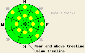
Near and above treeline, pockets of MODERATE avalanche danger exist on all aspects steeper than 35 degrees due to shifting winds wind loading a variety of slopes. Very isolated areas of deep slab instability linger near and above treeline on NW-N-NE aspects in rocky terrain, 40 degrees and steeper. Below treeline pockets of MODERATE danger remain on wind-loaded NW-N-NE-E-SE aspects steeper than 35 degrees. |
|
|
|
Another 3-5 inches of cold, light (6-8% density) snow fell across the forecast area last night. The forecast calls for snow showers to continue over the mountains this morning with another 1-3 inches of accumulation possible. By 10 am, most of these showers should end and the winds should shift to the northwest and start to decrease. Winds should continue to shift to the north and east and decrease tonight as the low pressure moves out of the area. A high-pressure ridge moving into the region tomorrow should bring mostly sunny skies, warmer temperatures, and lighter winds.
Observations from Hidden Peak yesterday showed that below 7400 ft. "dust on crust" conditions existed on the SE-E-NE-N aspects during the morning. As the sun warmed up the snow surface, 1-2 inches of wet snow formed on the surface on the SE aspects up to 8300 ft. This wet snow should have refrozen last night leaving a crust behind for last night's snow to fall on. On the more northerly aspects above 7400 ft., soft, unconsolidated snow gradually gave way to more dense, well-bonded snow deeper in the snowpack (snowpit). Near and above treeline, in wind-loaded areas, a thin, stiff wind slab had formed under about 2-4 inches of cohesion-less, low-density snow. Layer bonding tests indicated that this wind slab had not bonded well to the soft snow below it. However, observations also indicated that this wind slab only existed in pockets of wind-loaded terrain near and above treeline and that it was not very thick or continuous. In non-wind-loaded areas observations indicated a mostly stable snowpack.
Avalanche concern #1: Wind slabs
Wind slabs that formed over the last 2 days and new wind slabs that form today as the winds redistribute snow will remain the number one avalanche concern. Last night's new snow and southwest winds again added more weight and size to the wind slabs sitting on the wind-loaded NW-N-NE-E-SE aspects. As the winds shift to the northwest today, they will start to strip snow away from some of these wind-loaded slopes and redeposit it onto the NE-E-SE-S-SW aspects forming new stiff, fragile wind slabs on those slopes. These wind slabs will form on a mix of crusts, soft snow, and wind-affected snow surfaces. All of these surfaces could serve as weak layers and bed surfaces. Human-triggered avalanches due to the failures of wind slabs will remain possible possible on wind-loaded terrain at all elevations. Most of these types of avalanche should only involve the newly-formed wind slabs; however, some could still step down to the Feb 19th layer in isolated areas of complex, steep terrain.
Avalanche Concern #2: Deep slabs
Very isolated areas of deep slab instability still lurk near and above treeline on pockets of very steep (over 40 degrees), rocky, complex terrain on NW-N-NE aspects where a shallow snowpack allows the Feb 19 weak layer to live closer to to the surface. Human triggered avalanche activity on this layer remains unlikely except in these very isolated pockets of extreme terrain where a trigger in the right spot on the slope could still break the bonds between this weak layer and the snow above it.
Near and above treeline, pockets of MODERATE avalanche danger exist on all aspects steeper than 35 degrees due to shifting winds wind loading a variety of slopes. Very isolated areas of deep slab instability linger near and above treeline on NW-N-NE aspects in rocky terrain, 40 degrees and steeper. Below treeline pockets of MODERATE danger remain on wind-loaded NW-N-NE-E-SE aspects steeper than 35 degrees.
| 0600 temperature: | 12 deg. F. |
| Max. temperature in the last 24 hours: | 21 deg. F. |
| Average wind direction during the last 24 hours: | Northeast until midday yesterday then shifting to the southwest |
| Average wind speed during the last 24 hours: | Northeast: 15 mph | Southwest: 35 mph |
| Maximum wind gust in the last 24 hours: | 65 mph |
| New snowfall in the last 24 hours: | 3-5 inches |
| Total snow depth: | 94-126 inches |
For 7000-8000 ft: |
|||
| Wednesday: | Wednesday Night: | Thursday: | |
| Weather: | Snow showers in the morning. Snow ending by 10 am. Partly cloudy this afternoon with a slight chance for isolated snow showers. | Partly cloudy | Partly cloudy |
| Temperatures: | 19-24 deg. F. | 10-17 deg. F. | 32-38 deg. F. |
| Wind direction: | Northwest | North shifting to the east | East |
| Wind speed: | 10-20 mph with gusts to 40 mph in the morning | up to 10 mph increasing to 10-15 mph with gusts to 25 after midnight | up to 10 mph in the morning decreasing in the afternoon |
| Expected snowfall: | 1-3 in. | O in. | O in. |
For 8000-9000 ft: |
|||
| Wednesday: | Wednesday Night: | Thursday: | |
| Weather: | Snow showers in the morning. Snow ending by 10 am. Partly cloudy this afternoon with a slight chance for isolated snow showers. | Partly cloudy | Partly cloudy |
| Temperatures: | 12-18 deg. F. | 5-15 deg. F. | 28-34 deg. F. |
| Wind direction: | Northwest | North shifting to the northeast | Northeast shifting to the northwest |
| Wind speed: | 20-30 mph with gusts to 45 mph | 15-25 mph with gusts to 50 mph decreasing to 10 -20 mph with gusts to 30 mph after midnight | up to 10 mph |
| Expected snowfall: | 1-3 in. | O in. | O in. |


This website is owned and maintained by the non-profit arm of the Sierra Avalanche Center. Some of the content is updated by the USDA avalanche forecasters including the forecasts and some observational data. The USDA is not responsible for any advertising, fund-raising events/information, or sponsorship information, or other content not related to the forecasts and the data pertaining to the forecasts.

