In partnership with: 
|
March 14, 2010 at 7:00 am |
|
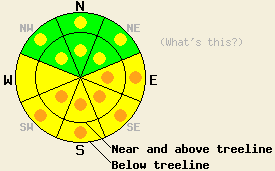
Pockets of CONSIDERABLE avalanche danger will form on E-SE-S-SW aspects 35 degrees and steeper due to warming instability today. Pockets of MODERATE avalanche danger will exist both above and below treeline on all other aspects 35 degrees and steeper. |
|
|
|
East and northeast winds started to increase last night around 5pm. They remained strong along the ridgetops through the night averaging 40-45 mph. These winds should start to decrease today as a high-pressure ridge settles over the forecast area. This high pressure will bring continued clear skies and much warmer temperatures to the region over the next few days. The forecast calls for today's high temperatures to climb 10 to 15 degrees above yesterday's.
Observations along Andesite Ridge near Donner Summit yesterday showed a natural avalanche that most likely occurred on Friday night (photos) due to instabilities in the storm snow. Snowpit observations and layer bonding tests near this slide showed that by mid-morning yesterday, the storm snow weaknesses had already gained strength in that area. Other observations also pointed to a mostly stable snowpack on the cold northerly aspects in that area. Observations showed that the cold temperatures and the moderate north to east winds were keeping the snow surfaces on NE-E-SE-S slopes exposed to this wind nice and cool. On the sheltered, sun-exposed E-SE-S aspects some surface warming and melting did start to occur by mid morning. Backcountry skiers north of the forecast area reported a skier-triggered avalanche on a low-elevation, east-facing, 38-degree slope (photo and details).
Avalanche concern #1: Warming instability
Daytime highs 10 to 15 degrees warmer than yesterday, the intense March sunshine, and a decrease in the cold north and easterly winds will make avalanches due to rapid warming the number one avalanche concern again today. Natural and human triggered point releases and slab avalanches large to bury or injure a person will remain possible. The sun-exposed E-SE-S-SW aspects below 9500' hold the greatest potential for these kinds of slides with the risk increasing at lower elevations, but these warming instabilities are also possible on other sun-exposed aspects and at higher elevations.
Avalanche concern #2: Wind slabs
Last night's strong N-NE-E winds transported snow from the previously wind-loaded aspects onto to the S-SW-W-NW aspects. This wind loading created new wind slabs on these slopes. Human-triggered avalanches involving these new wind slabs will be possible today near and above treeline on the most wind-loaded slopes. Older wind slabs on the N-NE-E aspects should be more difficult to trigger today. However, some of these slabs may still react to the added weight of a person on wind-loaded slopes sheltered from the strong NE winds and on sun-exposed, E-facing slopes. These older wind slabs will most likely exist near and below treeline.
Pockets of CONSIDERABLE avalanche danger will form on E-SE-S-SW aspects 35 degrees and steeper due to warming instability today. Pockets of MODERATE avalanche danger will exist both above and below treeline on all other aspects 35 degrees and steeper.
| 0600 temperature: | 14-18 deg. F. |
| Max. temperature in the last 24 hours: | 16-24 deg. F. |
| Average wind direction during the last 24 hours: | East northeast |
| Average wind speed during the last 24 hours: | before 5pm yesterday: 18 mph | after 5pm yesterday: 40-45 mph |
| Maximum wind gust in the last 24 hours: | 84 mph |
| New snowfall in the last 24 hours: | O inches |
| Total snow depth: | 97-131 inches |
For 7000-8000 ft: |
|||
| Sunday: | Sunday Night: | Monday: | |
| Weather: | Sunny | Clear | Sunny and warm |
| Temperatures: | 36-44 deg. F. | 30-36 deg. F. | 47-52 deg. F. |
| Wind direction: | Shifting between northeast and east | East | South |
| Wind speed: | 10-15 mph with gusts to 25 mph | up to 10 mph | up to 10 mph |
| Expected snowfall: | O in. | O in. | O in. |
For 8000-9000 ft: |
|||
| Sunday: | Sunday Night: | Monday: | |
| Weather: | Sunny | Clear | Sunny and warm |
| Temperatures: | 34-40 deg. F. | 28-34 deg. F. | 40-47 deg. F. |
| Wind direction: | Shifting between northeast and east | East becoming variable after midnight | South shifting to southwest |
| Wind speed: | 15-20 mph with gusts to 40 mph decreasing to 10-20 mph. 25-35 mph with gusts to 55 mph along the Sierra Crest. | 10-15 mph decreasing to 10 mph | 10 -20 mph |
| Expected snowfall: | O in. | O in. | O in. |


This website is owned and maintained by the non-profit arm of the Sierra Avalanche Center. Some of the content is updated by the USDA avalanche forecasters including the forecasts and some observational data. The USDA is not responsible for any advertising, fund-raising events/information, or sponsorship information, or other content not related to the forecasts and the data pertaining to the forecasts.

