In partnership with: 
|
March 15, 2010 at 7:00 am |
|
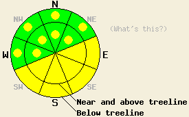
The avalanche danger will rise to MODERATE on the sun-exposed E-SE-S-SW slopes steeper than 35 degrees due to daytime warming today. Pockets of MODERATE danger linger on the most heavily wind loaded W-NW-N-NE aspects steeper than 35 degrees. |
|
|
|
The high-pressure ridge should keep sunny skies, light winds, and warm temperatures over the forecast area today. Daytime highs should reach into the mid to upper 40's above 8000'. A low pressure passing north of the region tomorrow could bring a few high clouds to the Sierra by tomorrow afternoon.
Some skier-triggered whumphing occurred on a W-facing aspect in Horse Canyon (near Bear Valley), yesterday. Snowpit observations and layer bonding tests indicated a weakness about 12 inches below the snow surface. These tests indicated that light to moderate force could break this weakness. On Flagpole Peak (Echo Summit area) and on Incline Lake Peak (Mt. Rose area), layer bonding tests also showed some lingering storm snow weaknesses near the base of Friday night's snow on the N-NE aspects. On Castle Peak (Donner Summit area), some skier triggered cracking occurred on small NW- facing, wind-loaded, test slopes near the summit of Castle Peak. The wind slabs that had formed on these slopes did not extend very far down slope. In all of these areas a few inches of wet, heavy snow formed on the surface of the sun-exposed aspects by mid-afternoon. On Incline Lake Peak this wet snow extended up to 9000'. However, very little wet snow instabilities like point-release slides and roller balls occurred.
Avalanche concern #1: Warming instability
Daytime highs in the mid 40's to low 50's, the intense March sunshine, and light winds will make avalanches due to rapid warming the number one avalanche concern again today. Human triggered point releases and slab avalanches large to bury or injure a person will remain possible. Some natural point-release and roller ball activity may also occur today on the most sun exposed aspects especially on steep slopes near rocks and cliffs. The sun-exposed E-SE-S-SW aspects below 9500' hold the greatest potential for these kinds of slides with the risk increasing at lower elevations, but these warming instabilities are also possible on other sun-exposed aspects and at higher elevations.
Avalanche concern #2: Wind slabs
Human-triggered avalanches involving recently-formed wind slabs will be possible today on pockets of terrain near and above treeline on the most wind-loaded slopes. More recent wind slabs due to the E and NE winds could exist on the S-SW-W-NW aspects above treeline. Older wind slabs could still exist on the the NW-N-NE-E aspects near and below treeline on slopes sheltered from the E and NE winds. Some of these slabs may still react to the added weight of a person on wind-loaded slopes. As the snow continues to settle and consolidate these wind slabs will become more difficult to trigger.
The avalanche danger will rise to MODERATE on the sun-exposed E-SE-S-SW slopes steeper than 35 degrees due to daytime warming today. Pockets of MODERATE danger linger on the most heavily wind loaded W-NW-N-NE aspects steeper than 35 degrees.
| 0600 temperature: | 25-35 deg. F. |
| Max. temperature in the last 24 hours: | 35-42 deg. F. |
| Average wind direction during the last 24 hours: | East |
| Average wind speed during the last 24 hours: | 20-25 mph |
| Maximum wind gust in the last 24 hours: | 43 mph |
| New snowfall in the last 24 hours: | O inches |
| Total snow depth: | 94-131 inches |
For 7000-8000 ft: |
|||
| Monday: | Monday Night: | Tuesday: | |
| Weather: | Sunny | Clear | Sunny with high clouds developing in the afternoon. |
| Temperatures: | 46-51 deg. F. | 28-38 deg. F. | 44-49 deg. F. |
| Wind direction: | Southeast shifting to the southwest | South | Southwest |
| Wind speed: | 5-10 mph | up to 10 mph | 10-15 mph |
| Expected snowfall: | O in. | O in. | O in. |
For 8000-9000 ft: |
|||
| Monday: | Monday Night: | Tuesday: | |
| Weather: | Sunny | Clear | Sunny with high clouds developing in the afternoon. |
| Temperatures: | 45-51 deg. F. | 28-34 deg. F. | 38-45 deg. F. |
| Wind direction: | Southeast shifting to the southwest | South | Southwest |
| Wind speed: | 5-15 mph with gusts to 25 mph | 10-20 mph with gusts to 30 mph | 10-20 mph with gusts to 30 mph |
| Expected snowfall: | O in. | O in. | O in. |


This website is owned and maintained by the non-profit arm of the Sierra Avalanche Center. Some of the content is updated by the USDA avalanche forecasters including the forecasts and some observational data. The USDA is not responsible for any advertising, fund-raising events/information, or sponsorship information, or other content not related to the forecasts and the data pertaining to the forecasts.

