In partnership with: 
|
March 18, 2010 at 6:35 am |
|
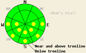
Early this morning, avalanche danger is LOW for all elevations and aspects. Isolated pockets of MODERATE avalanche danger will form mainly below 8,500' on E-SE-S-SW-W aspects 37 degrees and steeper in response to daytime warming. |
|
|
|
Skies began to clear over the forecast area overnight. Plenty of sunshine with isolated showers in areas south of Lake Tahoe are expected this afternoon. Ridgetop winds are light out of the northeast this morning and are expected to increase to moderate in speed this afternoon. A cold front passage today combined with cool northeast winds will keep maximum daytime air temperatures about 10 degrees colder than yesterday at the upper elevations. Remote sensors above 8,000' are reporting air temperatures in the upper 20s to mid 30s this morning.
Observations made yesterday on Jake's Peak (West Shore Tahoe area) revealed that snow surface conditions during the mid morning hours ranged from wet to melt freeze (frozen phase) to cold snow not affected by melt freeze. On N-NE aspects melt freeze snow existed below 8,200' with cold snow unaffected by met freeze above 8,200'. On E-SE-S aspects, melt freeze conditions existed all the way to the summit at 9,100' (more info). Similar snow surface condition were observed on Incline Lake Peak (Mount Rose area) with significant free water noted in the top 4 to 8 inches of the snowpack at 9,100' on an E aspect at 11:30 am (photos, more info). A decent overnight refreeze is expected to have occurred last night with the aid of radiational cooling under clearing skies and near to below freezing air temperatures.
Avalanche concerns: Warming instability
Avalanche concerns for today continue to focus on wet snow instability. A decent overnight refreeze and colder air temperatures today are expected to keep areas of wet snow instabilities fairly isolated. The most likely areas for instabilities to form today are on E-SE-S-SW-W aspects below 8,500'. Very isolated areas of instability are possible on NW-N-NE aspects below 7,500' as well. Any instability will most likely take the form of loose snow avalanches involving the top few inches of wet surface snow. Deep wet slab instability remains unlikely at this time. Minimal snow is available for wind transport today, minimizing any concerns for new wind loading by NE ridgetop winds.
Early this morning, avalanche danger is LOW for all elevations and aspects. Isolated pockets of MODERATE avalanche danger will form mainly below 8,500' on E-SE-S-SW-W aspects 37 degrees and steeper in response to daytime warming.
| 0600 temperature: | 29 to 35 deg. F. |
| Max. temperature in the last 24 hours: | 48 to 52 deg. F. |
| Average wind direction during the last 24 hours: | east shifting to southwest shifting to northeast |
| Average wind speed during the last 24 hours: | 10 mph |
| Maximum wind gust in the last 24 hours: | 23 mph |
| New snowfall in the last 24 hours: | O inches |
| Total snow depth: | 86 to 124 inches |
For 7000-8000 ft: |
|||
| Thursday: | Thursday Night: | Friday: | |
| Weather: | Partly cloudy skies with isolated snow showers south of Lake Tahoe in the afternoon, otherwise sunny. | Clear skies. | Sunny skies. |
| Temperatures: | 35 to 45 deg. F. | 25 to 30 deg. F. | 47 to 52 deg. F. |
| Wind direction: | NE | E | E |
| Wind speed: | Up to 10 mph in the morning increasing to 10 to 20 mph with gusts to 35 mph by afternoon. | 10 to 15 mph with gusts to 45 mph. Winds decreasing to 10 to 20 mph with gusts to 35 mph after midnight. | 10 to 15 mph in the morning, becoming light. |
| Expected snowfall: | 0 to trace in. | O in. | O in. |
For 8000-9000 ft: |
|||
| Thursday: | Thursday Night: | Friday: | |
| Weather: | Partly cloudy skies with isolated snow showers south of Lake Tahoe in the afternoon, otherwise sunny. | Clear skies. | Sunny skies. |
| Temperatures: | 30 to 35 deg. F. | 22 to 28 deg. F. | 40 to 47 deg. F. |
| Wind direction: | NE | NE | NE shifting to N |
| Wind speed: | 10 to 20 with gusts to 35 mph. Winds increasing to 20 to 35 with gusts to 70 mph in the afternoon. | 20 to 35 mph with gusts to 60 mph. | 10 to 20 mph with gusts to 30 mph. Winds decreasing to 5 to 15 mph by afternoon. |
| Expected snowfall: | 0 to trace in. | O in. | O in. |


This website is owned and maintained by the non-profit arm of the Sierra Avalanche Center. Some of the content is updated by the USDA avalanche forecasters including the forecasts and some observational data. The USDA is not responsible for any advertising, fund-raising events/information, or sponsorship information, or other content not related to the forecasts and the data pertaining to the forecasts.

