In partnership with: 
|
March 22, 2010 at 6:50 am |
|
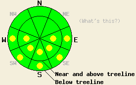
This morning, LOW avalanche danger exists for all elevations and aspects. Some pockets of MODERATE avalanche danger may develop today on sun-exposed E-SE-S-SW-W aspects 37 degrees and steeper below 9000' due to daytime warming. |
|
|
|
As the small low pressure leaves the forecast area today, the skies should clear and the winds should decrease. A pool of cold air should remain over the forecast area through tonight. The winds should start to shift to the north and east tonight as a high-pressure ridge builds over the area. This ridge should bring warmer temperatures back to the region tomorrow.
Yesterday, colder temperatures, thin high clouds, and strong winds kept most of the snow surfaces frozen until mid to late afternoon. On Incline Lake Peak, the SE-S-SW aspects started to soften around 12:30 pm. By 1 pm a thin layer (less than 1 inch) of corn snow existed in sun-exposed areas on these aspects. Firm, refrozen melt-freeze snow existed below the surface on the southerly aspects. On the northerly aspects, a thin and variable crust existed on snow surface up to 9400' (photo). In some areas this crust would support a skier's weight, and in other areas it would not. On the exposed northerly aspects near the summit ridgeline, a mix of wind-packed snow and wind-scoured snow existed on the surface. Snowpit observations showed cold, well-bonded snow below the surface on the northerly aspects. Remote sensors indicated that overnight lows dropped below freezing above 7500' again last night and that mostly clear skies prevailed through the night. This combination of conditions will have allowed the snowpack to undergo a strong overnight refreeze. Below 7500' the snowpack should have released enough heat into the clear night sky to refreeze even though temperatures remained slightly above freezing.
Avalanche concerns:
A strong overnight refreeze and cooler daytime highs will work to limit the melting and warming that occurs in the snowpack today. Less warming and melting means less wet snow instabilities. The intense March sunshine could cause enough melting and warming on the most sun-exposed slopes on the E-SE-S-SW-W aspects for some pockets of wet-snow instabilities to form. Any wet-snow instabilities that do form today should be limited to loose snow avalanches, roller-balls, and pinwheels involving the wet surface snow. If you find yourself sinking into wet snow up to the top of your boots or start seeing/triggering pinwheels and roller-balls, move to an aspect where less melting has occurred or to lower angle terrain.
This morning, LOW avalanche danger exists for all elevations and aspects. Some pockets of MODERATE avalanche danger may develop today on sun-exposed E-SE-S-SW-W aspects 37 degrees and steeper below 9000' due to daytime warming.
| 0600 temperature: | 29 deg. F. |
| Max. temperature in the last 24 hours: | 38-44 deg. F. |
| Average wind direction during the last 24 hours: | Southwest |
| Average wind speed during the last 24 hours: | 40 mph |
| Maximum wind gust in the last 24 hours: | 65-72 mph |
| New snowfall in the last 24 hours: | O inches |
| Total snow depth: | 80-120 inches |
For 7000-8000 ft: |
|||
| Monday: | Monday Night: | Tuesday: | |
| Weather: | Partly cloudy | Mostly clear | Sunny |
| Temperatures: | 41-48 deg. F. | 17-24 deg. F. | 40-47 deg. F. |
| Wind direction: | West | North shifting to the northeast after midnight | East |
| Wind speed: | 10-15 mph with gusts to 25 mph | 10-15 mph | 10-20 mph with gusts to 35 mph |
| Expected snowfall: | O in. | O in. | O in. |
For 8000-9000 ft: |
|||
| Monday: | Monday Night: | Tuesday: | |
| Weather: | Partly cloudy | Mostly clear | Sunny |
| Temperatures: | 38-44 deg. F. | 14-21 deg. F. | 39-45 deg. F. |
| Wind direction: | West | North shifting to the northeast after midnight | East |
| Wind speed: | 20-30 mph with gusts to 55 mph decreasing to 15-20 mph with gusts to 35 mph in the afternoon | 10-20 mph increasing to 15-25 mph with gusts to 40 mph after midnight | 15-25 mph with gusts to 50 mph |
| Expected snowfall: | O in. | O in. | O in. |


This website is owned and maintained by the non-profit arm of the Sierra Avalanche Center. Some of the content is updated by the USDA avalanche forecasters including the forecasts and some observational data. The USDA is not responsible for any advertising, fund-raising events/information, or sponsorship information, or other content not related to the forecasts and the data pertaining to the forecasts.

