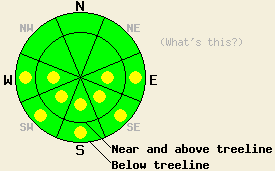
This Avalanche Advisory was published on March 24, 2010:

|
March 24, 2010 at 7:00 am |
|
Early this morning, avalanche danger is LOW for all elevations and aspects. Pockets of MODERATE avalanche danger will develop today on sun-exposed E-SE-S-SW-W aspects 37 degrees and steeper in response to daytime warming. |
|
|
|
Forecast Discussion:
A transitional day of sun, above freezing air temperatures, and light to moderate southwest ridgetop winds is expected for today. High level cloud cover will increase throughout the day ahead of an approaching weather system that is forecast to bring light snowfall to the region after midnight. Cloud cover and cooler air temperatures are expected tonight through Thursday night. An air temperature inversion is in place this morning in many areas, with the coldest air existing below 6,500' in mountain valleys. Remote sensors above 8,000' are reporting air temperatures in the mid 30s in most locations. The exception is below freezing air temperatures reported from 8,300' in the Carson Pass area.
Observations made yesterday on Mt. Tallac (Desolation Wilderness area) revealed the strongest overnight refreeze of the week had occurred Monday night with 4 to 8 inches of melt freeze crust on the surface at all elevations traveled between 6,500' and 9,100'. Melt freeze conditions existed in nearly all areas with pockets of cold wind pressed snow not affected by melt freeze on northerly aspects above 8,900'. Very supportable conditions existed on descent at 11am with 1 to 3 inches of wet snow over frozen melt freeze crust on E-SE aspects. NE aspects remained very frozen with less than 1 inch of wet surface snow at that time. No evidence of instability was observed during field observations between 8am and noon. Air temperatures last night were 8 to 14 degrees warmer than Monday night and above freezing in most locations. Overnight refreeze of wet surface snow from yesterday was mostly reliant on radiational cooling. As a result, a weaker surface refreeze is expected to have occurred last night.
Avalanche concerns:
Avalanche concerns for today continue to focus on warming instability. A weaker overnight refreeze last night will allow for a shorter period of widespread frozen snow surface conditions early this morning. As the day progresses, pockets of wet snow instability will form in sun exposed areas on E-SE-S-SW-W aspects. Once the top few inches of frozen snow surface melts, several feet of wet snow will exist in the upper portion of the snowpack in most sun exposed areas. Once the supportable near surface or surface crust is melted, avalanche danger will increase. This change in conditions from a stable to an unstable snowpack may occur rapidly over a period as short as 20 minutes. The actual amount and thickness of cloud cover today will play a major roll in how quickly snow surface melting occurs. Recent observations indicate that wet loose avalanche activity is the most likely form of instability, however, a very isolated wet slab avalanche is not impossible.
The bottom line:
Early this morning, avalanche danger is LOW for all elevations and aspects. Pockets of MODERATE avalanche danger will develop today on sun-exposed E-SE-S-SW-W aspects 37 degrees and steeper in response to daytime warming.
Weather Observations from along the Sierra Crest between 8200 ft and 8800 ft:
| 0600 temperature: | 26 to 36 deg. F. |
| Max. temperature in the last 24 hours: | 44 to 52 deg. F. |
| Average wind direction during the last 24 hours: | east shifting to southwest |
| Average wind speed during the last 24 hours: | 25 mph |
| Maximum wind gust in the last 24 hours: | 49 mph |
| New snowfall in the last 24 hours: | O inches |
| Total snow depth: | 78 to 118 inches |
Two-Day Mountain Weather Forecast - Produced in partnership with the Reno NWS
For 7000-8000 ft: |
|||
| Wednesday: | Wednesday Night: | Thursday: | |
| Weather: | Increasing high clouds. | Partly cloudy skies in the evening becoming cloudy. Scattered snow showers after midnight. Numerous snow showers near the Sierra Crest. | Mostly cloudy skies with a slight chance of snow showers. |
| Temperatures: | 42 to 49 deg. F. | 19 to 26 deg. F. | 33 to 39 deg. F. |
| Wind direction: | SW | SW | SW |
| Wind speed: | 5 to 10 mph increasing to 10 to 15 mph with gusts to 25 mph in the afternoon. | 10 to 20 mph increasing to 15 to 25 mph with gusts to 40 mph after midnight. | 15 to 25 mph with gusts to 50 in the morning. Winds decreasing to 10 to 20 mph with gusts to 30 mph. |
| Expected snowfall: | O in. | Up to 3 in. | trace in. |
For 8000-9000 ft: |
|||
| Wednesday: | Wednesday Night: | Thursday: | |
| Weather: | Increasing high clouds. | Partly cloudy skies in the evening becoming cloudy. Scattered snow showers after midnight. Numerous snow showers near the Sierra Crest. | Mostly cloudy skies with a slight chance of snow showers. |
| Temperatures: | 38 to 45 deg. F. | 18 to 24 deg. F. | 24 to 32 deg. F. |
| Wind direction: | SW | SW | SW |
| Wind speed: | 15 to 25 mph with gusts to 35 mph in the afternoon. | 25 to 35 mph with gusts to 60 mph in the evening. Winds increasing to 35 to 50 mph with gusts to 85 mph after midnight. | 20 to 35 mph with gusts to 65 mph. Gusts decreasing to 45 mph in the afternoon. |
| Expected snowfall: | O in. | Up to 3 in. | trace in. |


