In partnership with: 
|
March 26, 2010 at 7:00 am |
|
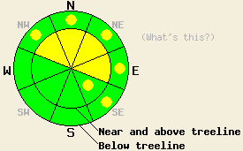
MODERATE avalanche danger exists in near and above treeline terrain on NW-N-NE-E aspects, 35 degrees and steeper with pockets of MODERATE danger on SE aspects. Below treeline avalanche danger is LOW with pockets of MODERATE danger in wind affected areas on NW-N-NE-E-SE aspects 35 degrees and steeper. |
|
|
|
Last night, 2-4 inches of cold, light snow (7-8% density) fell across the forecast area. Southwest winds averaging 30-35 mph continued to blow until early this morning when they shifted to the northwest and started to decrease. The northwest winds should continue today as a high pressure starts to build over the forecast area. Clear skies should also start to return to the Sierra as this high moves in. By tomorrow the winds should shift to the east and daytime highs should start to warm back up.
Yesterday, the strong southwest winds and the new snow formed small wind slabs on the leeward slopes near and above treeline. Ski cuts and dropping oven-sized cornices onto the wind-loaded slopes on the east ridge of Tamarack Peak in the Mt. Rose backcountry caused these new winds slabs to fail. The resulting avalanches ranged from 6 to 18 inches deep and 15 to 60 feet wide. These slides only entrained the newly formed wind slabs and only ran 30 to 60 feet downhill. All of these slides occurred on N-NE facing, 38-42 degree slopes near ridgelines. These wind slabs only existed on open wind-loaded slopes near and above treeline. Below treeline on non-wind-affected slopes, the 3 inches of new snow sat on top of old crusts in most places. These crusts were less prevalent on some of the shaded north aspects. On Elephant's Back near Carson Pass, less snow meant smaller, more isolated wind slabs. In areas where these wind slabs existed, they could be triggered by a skier. In both the Mt. Rose area and Elephant's Back area, a layer of graupel (snow's equivalent to ball bearings) 2-3 inches above the base of the new snow served as the failure layer. Wind scoured and wind packed surfaces with a dusting of new snow on top of them existed in most of the Elephant's Back area.
Avalanche concern #1: Wind Slabs
Wind slabs that have formed since Wednesday night will remain the primary avalanche concern today. These slabs should be slightly larger and more widespread today due last night's new snow and continued southwest winds. Human triggering of these wind slabs will remain possible today. The wind loaded, N-NE-E aspects near and above treeline will hold the largest and most tender of these wind slabs. Cross loading on the NW and SE aspects should have also created some wind slabs on these slopes in near and above treeline terrain. As the winds shift to the NW today, they will move more snow onto the SE aspects adding size to the wind slabs that currently exist on those aspects.
Avalanche concern #2: Warming instabilities
As the intense March sun hits the new snow, some isolated areas of instability may form on sun-exposed aspects. Most of these instabilities should present as roller balls and point-release slides; however, some slab avalanches could occur especially on steep, SE-facing slopes with new snow on them. These warming instabilities should be most common below 8000', but they are not impossible at some of the higher elevations on the most sun-exposed slopes.
MODERATE avalanche danger exists in near and above treeline terrain on NW-N-NE-E aspects, 35 degrees and steeper with pockets of MODERATE danger on SE aspects. Below treeline avalanche danger is LOW with pockets of MODERATE danger in wind affected areas on NW-N-NE-E-SE aspects 35 degrees and steeper.
| 0600 temperature: | 16 deg. F. |
| Max. temperature in the last 24 hours: | 24 deg. F. |
| Average wind direction during the last 24 hours: | Southwest shifting to northwest this morning |
| Average wind speed during the last 24 hours: | 35 mph |
| Maximum wind gust in the last 24 hours: | 69 mph |
| New snowfall in the last 24 hours: | 2-4 inches |
| Total snow depth: | 86-125 inches |
For 7000-8000 ft: |
|||
| Friday: | Friday Night: | Saturday: | |
| Weather: | Mostly sunny | Partly cloudy in the evening then clearing overnight | Sunny |
| Temperatures: | 34-42 deg. F. | 17-24 deg. F. | 38-45 deg. F. |
| Wind direction: | Northwest | Northwest shifting to the northeast | East |
| Wind speed: | 10 mph with gusts to 25 mph | 10 mph with gusts to 25 mph increasing ot gusts to 35 mph after midnight | 10 mph with gusts to 25 mph |
| Expected snowfall: | O in. | O in. | O in. |
For 8000-9000 ft: |
|||
| Friday: | Friday Night: | Saturday: | |
| Weather: | Mostly sunny | Partly cloudy in the evening then clearing overnight | Sunny |
| Temperatures: | 28-36 deg. F. | 16-23 deg. F. | 34-45 deg. F. |
| Wind direction: | Northwest | North shifting to northeast | East |
| Wind speed: | 15-25 mph with gusts to 55 mph | 15-25 mph with gusts to 50 mph | 10 -15 mph |
| Expected snowfall: | O in. | O in. | O in. |


This website is owned and maintained by the non-profit arm of the Sierra Avalanche Center. Some of the content is updated by the USDA avalanche forecasters including the forecasts and some observational data. The USDA is not responsible for any advertising, fund-raising events/information, or sponsorship information, or other content not related to the forecasts and the data pertaining to the forecasts.

