In partnership with: 
|
March 28, 2010 at 6:54 am |
|
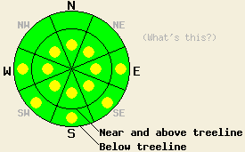
Pockets of MODERATE avalanche danger will form on the sun-exposed E-SE-S-SW-W aspects on slopes 35 degrees and steeper due to daytime warming today. Near and above treeline a few isolated pockets of MODERATE danger may still exist on the most wind-loaded NW-N-NE aspects steeper than 37 degrees north of Lake Tahoe. |
|
|
|
A strong low pressure dropping out of the Gulf of Alaska should begin to push the high pressure over the forecast area towards the east. The winds have already shifted back to the southwest and increased ahead of this storm. The winds should continue to increase as this low moves closer. The forecast calls for sustained ridgetop winds above 50 mph with gusts over 110 mph by tomorrow afternoon. Cloud cover should also start to increase later today and become widespread by tonight. By tomorrow afternoon/evening precipitation should start to fall. Snow levels should start between 7500 and 8000 ft during the day tomorrow and lower during the storm. Check the Reno NWS site for more details and updates on the approaching storm.
Snowpit data and layer bonding tests from Jake's Peak (West Shore area) and Horse Canyon (Bear Valley area) showed continued settlement in the recent snow. Moderate force did still break the bonds between the graupel layer near the base of the recent snow and the snow above it on a NE facing aspect on Jake's Peak. However, ski cuts on test slopes in this area did not produce any signs of instabilities on the N-NE facing slopes where this graupel layer still exists. 4-8 inches of soft snow remained on the N-NE facing aspects on Jake's Peak above 7500'. Above 8000', a thin, barely noticeable crust existed below this snow. Below 8000' this crust became thicker and more widespread leading to more "dust on crust" conditions on the lower elevation slopes. Melt-freeze cycles over the last few days have quickly transformed most of the snow on the more sun-exposed E-SE-S aspects below 8000' into melt-freeze snow. On Jake's by noon yesterday, SE facing slopes below 8000 ft had 1-2 inches of soft corn snow sitting on top of a supportable melt-freeze crust. Above 8000' some of the snow on these sun exposed aspects has not fully changed to melt-freeze snow and remains wet and sticky. Remote sensors indicated that temperatures in most areas below 8300' remained above freezing last night. Even though the snowpack should have released enough heat into the atmosphere to refreeze some clouds and the warmer overnight temperatures should have caused a weaker refreeze last night.
Avalanche concern #1: Warming instabilities
The intense March sunshine, a weaker overnight refreeze, and daytime highs in the upper 40's and low 50's, should allow enough warming and melting to occur today for wet-snow instabilities to form on sun-exposed aspects. Most of these instabilities should present as roller balls and point-release slides; however, some slab avalanches could occur especially on steep, SE-facing slopes where the recent snow has not fully transformed from cold, new snow into melt-freeze snow (corn). These warming instabilities should be most common on SE-S-SW aspects below 9000', but they are not impossible at some of the higher elevations on the most sun-exposed slopes and on some lower elevation northerly aspects. More widespread cloud cover than forecast today would help keep most of these wet snow instabilities in check.
Avalanche concern #2: Wind Slabs
A few isolated areas of human-triggerable wind slabs could still exist on steep, wind loaded, NW-N-NE aspects near and above treeline north of Lake Tahoe. These slabs should be more difficult to trigger today due to settlement in the snowpack. However, the right trigger in the right spot could still cause them to fail. Steep, complex terrain with unsupported snowfields, cliffs, convexities and other complicated terrain features will hold the most potential for these lingering slabs.
Pockets of MODERATE avalanche danger will form on the sun-exposed E-SE-S-SW-W aspects on slopes 35 degrees and steeper due to daytime warming today. Near and above treeline a few isolated pockets of MODERATE danger may still exist on the most wind-loaded NW-N-NE aspects steeper than 37 degrees north of Lake Tahoe.
| 0600 temperature: | 30-34 deg. F. |
| Max. temperature in the last 24 hours: | 42-49 deg. F. |
| Average wind direction during the last 24 hours: | East until 2 pm yesterday, then southwest |
| Average wind speed during the last 24 hours: | East: 20 mph | Southwest: 30-35 mph |
| Maximum wind gust in the last 24 hours: | 51 mph |
| New snowfall in the last 24 hours: | O inches |
| Total snow depth: | 84-123 inches |
For 7000-8000 ft: |
|||
| Sunday: | Sunday Night: | Monday: | |
| Weather: | Partly sunny with clouds increasing in the afternoon. | Mostly cloudy | Mostly cloudy with a 30-40% chance of rain by the afternoon. Snow levels between 7500' and 8000'. |
| Temperatures: | 43-50 deg. F. | 27-33 deg. F. | 44-49 deg. F. |
| Wind direction: | Southwest | Southwest | Southwest |
| Wind speed: | 10-15 mph with gusts to 30 mph increasing to 20-30 mph with gusts to 50 mph in the afternoon | 20-30 mph with gusts to 50 mph | 20-30 mph with gusts to 60 mph increasing to 30-45 mph with gusts to 75 mph in the afternoon |
| Expected snowfall: | O in. | O in. | Rain -.05 in. |
For 8000-9000 ft: |
|||
| Sunday: | Sunday Night: | Monday: | |
| Weather: | Partly sunny with clouds increasing in the afternoon. | Mostly cloudy | Mostly cloudy with a 40% chance of snow by the afternoon. |
| Temperatures: | 43-49 deg. F. | 22-29 deg. F. | 42-45 deg. F. |
| Wind direction: | Southwest | Southwest | Southwest |
| Wind speed: | 25-35 mph with gusts to 65 mph | 30-45 mph with gusts to 85 mph | 35-50 mph with gusts to 85 mph increasing to 45-55 mph with gusts to 110 mph |
| Expected snowfall: | O in. | O in. | less than .5 in. |


This website is owned and maintained by the non-profit arm of the Sierra Avalanche Center. Some of the content is updated by the USDA avalanche forecasters including the forecasts and some observational data. The USDA is not responsible for any advertising, fund-raising events/information, or sponsorship information, or other content not related to the forecasts and the data pertaining to the forecasts.

