In partnership with: 
|
March 29, 2010 at 7:03 am |
|
Avalanche danger is LOW for all elevations and aspects. Very isolated areas of instability may exist. Normal caution is advised. A significant increase in avalanche danger is expected to occur on Tuesday. |
|
|
|
A significant Gulf of Alaska storm system will begin to move into the forecast area today. Remote sensors this morning are reporting air temperatures above 8,000' in the upper 20s to mid 30s. With the jet stream moving over the region, strong southwest winds with current ridgetop gusts near 100 mph will increase to 115+ mph today and Tuesday. Increasing clouds, above freezing air temperatures, and a few rain and snow showers are expected this afternoon. Snow level is forecast at 7,000' for today and will fall with cold front passage and increasing snowfall rates Tuesday morning.
Recent observations from around the forecast are have observed two different types of instability within the upper portion of the snowpack. New snow this past week came with a layer of graupel crystals that remained active for several days and may still exist in an active state in very isolated areas. Isolated skier triggered cracking and snowpit data supporting the possibility of fracture propagation was seen Thursday through Saturday (more info). Typical spring conditions have continued the daily melt freeze cycle in sun exposed areas and in low elevation shaded areas. Some areas of warming instability occurred on Friday with no new reports of wet snow instability over the weekend. A decent snow surface refreeze is expected to have occurred last night under light cloud cover and near to below freezing air temperatures.
Avalanche concerns:
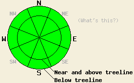
Avalanche concerns for today are few. Finding an area of lingering instability involving the grauple layer from this past week has become unlikely, but is not impossible. The most likely terrain for any ongoing instability to occur is near and above treeline north of Lake Tahoe on NW-N-NE aspects where slabs that formed this past week were up to 2 feet deep.
Increasing cloud cover today and convective cooling from strong winds is expected to keep areas of wet snow instability to a minimum despite some sun this morning and above freezing air temperatures this afternoon. Wet snow is expected to remain limited to the top few inches of the snow surface and not present a significant hazard to backcounty travelers today.
Avalanche danger is LOW for all elevations and aspects. Very isolated areas of instability may exist. Normal caution is advised. A significant increase in avalanche danger is expected to occur on Tuesday.
| 0600 temperature: | 27 to 34 deg. F. |
| Max. temperature in the last 24 hours: | 39 to 46 deg. F. |
| Average wind direction during the last 24 hours: | Southwest |
| Average wind speed during the last 24 hours: | 45 mph |
| Maximum wind gust in the last 24 hours: | 100 mph |
| New snowfall in the last 24 hours: | O inches |
| Total snow depth: | 83 to 122 inches |
For 7000-8000 ft: |
|||
| Monday: | Monday Night: | Tuesday: | |
| Weather: | Mostly cloudy skies with isolated showers in the morning. Scattered showers in the afternoon. Snow level 7,000ft. | Cloudy skies with scattered showers in the evening. Snow likely after midnight. | Cloudy skies with snow in the morning. Snow showers in the afternoon. |
| Temperatures: | 43 to 50 deg. F. | 30 to 36 deg. F. | 34 to 40 deg. F. |
| Wind direction: | SW | SW | SW |
| Wind speed: | 20 to 30 mph with gusts to 55 mph. Winds increasing to 30 to 45 mph with gusts to 80 mph inthe afternoon. | 30 to 50 mph with gusts to 90 mph. | 25 to 35 mph with gusts to 75 mph. Gusts decreasing to 65 mph in the afternoon. |
| Expected snowfall: | 0 to trace in. | 2 to 5 in. | 6 to 10 in. |
For 8000-9000 ft: |
|||
| Monday: | Monday Night: | Tuesday: | |
| Weather: | Mostly cloudy skies with isolated showers in the morning. Scattered showers in the afternoon. | Cloudy skies with scattered showers in the evening. Snow likely after midnight. | Cloudy skies with snow in the morning. Snow showers in the afternoon. |
| Temperatures: | 42 to 48 deg. F. | 22 to 29 deg. F. | 25 to 32 deg. F. |
| Wind direction: | SW | SW shifting to W | W shifitng to SW |
| Wind speed: | 50 to 70 mph with gusts to 115 mph. | 55 to 75 mph increasing to 65 to 80 mph. Gusts up to 135 mph. | 65 to 75 mph with gusts to 120 mph. Winds decreasing to 50 to 60 mph with gusts to 100 mph. |
| Expected snowfall: | 0 to trace in. | 3 to 6 in. | 7 to 11 in. |


This website is owned and maintained by the non-profit arm of the Sierra Avalanche Center. Some of the content is updated by the USDA avalanche forecasters including the forecasts and some observational data. The USDA is not responsible for any advertising, fund-raising events/information, or sponsorship information, or other content not related to the forecasts and the data pertaining to the forecasts.

