In partnership with: 
|
March 31, 2010 at 6:57 am |
|
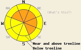
Along the Sierra Crest north of Hwy 50, avalanche danger is CONSIDERABLE near and above treeline on NW-N-NE-E-SE aspects 35 degrees and steeper. For all other areas, avalanche danger is MODERATE on all aspects on slopes 35 degrees and steeper. Large destructive avalanches are possible. |
|
|
|
Waves of moisture continue to pass through the forecast area and air temperatures continue to fall. Along the Sierra Crest north of Hwy 50 an additional 15 to 20 inches of new snow fell above 6,200' overnight. South of Hwy 50 and in the Carson Range, 4 to 7 inches of new snow fell above 7,000' overnight. This brings storm totals for the last 36 hours up to 10 to 30 inches of new snow. Air temperatures this morning above 8,000' are in the mid teens, about 10 degrees colder than 24 hours ago. Ridgetop winds remain out of the southwest this morning and have decreased in speed from gale force to light. A short period of high intensity snowfall this morning is expected to taper to snow showers this afternoon. An additional 5 to 9 inches of new snow is expected today.
Observations made yesterday in the Donner Summit and Carson Pass areas revealed some weaknesses within the new snow but very little fracture propagation. On Donner Peak (Donner Pass area) gale force winds near treeline were noted to keep windward aspects scoured down to the melt freeze/rain crust that existed on all aspects below 8,000' that formed at the start of the storm cycle on Monday afternoon. Large amounts of wind transport were observed with a wind loaded NE aspect 45 degree slope near treeline at 7,330' containing 160cm (5.3ft) of new snow. Snowpit data and test slope loading in this area revealed that the new snow was stabilizing rapidly with only the top 20cm (8 inches) of the snowpack failing as a slab. Maximum fracture propagation observed in this area was 2m (6.6ft) with most skier triggered cracking less than 1m (3.3ft) (photos, pit profile). On Carson pass, around 40cm (1.3ft) on new snow was noted as composed nearly entirely of graupel crystals. Failure of skier triggered test slopes was easy to initiate, but cracking only extended a few feet away from the skier and matched well with snowpit data collected nearby at 8,800' on a E aspect 35 degree slope below treeline (photos, pit profile).
Avalanche concern #1: Storm snow
High intensity snowfall this morning will continue to contribute to slab formation through weakness within the new snow based on specific crystal types and overburden from accumulating storm snow. Slabs will be most prevalent in open areas on NW-N-NE-E-SE aspects. Unstable slabs should be expected both above and below treeline, especially with large amounts of graupel associated with yesterday's snowfall. Large and destructive avalanches are possible and may occur within greater areas of seemingly stable snow.
Avalanche concern #2: Deep slab instability
New snow loading may add enough additional stress to the snowpack to cause failure at the crust layer that exists at the base of the storm snow below 8,000' or even deeper on the old snow graupel layer that formed during snowfall that fell March 24 and 25. The old snow graupel layer lingers on many, but not all NW-N-NE aspects and typically resides 6 to 24 inches below the old/new snow interface. Avalanches involving this amount of snow will be large and destructive.
Along the Sierra Crest north of Hwy 50, avalanche danger is CONSIDERABLE near and above treeline on NW-N-NE-E-SE aspects 35 degrees and steeper. For all other areas, avalanche danger is MODERATE on all aspects on slopes 35 degrees and steeper. Large destructive avalanches are possible.
| 0600 temperature: | 14 to 18 deg. F. |
| Max. temperature in the last 24 hours: | 24 to 28 deg. F. |
| Average wind direction during the last 24 hours: | Southwest |
| Average wind speed during the last 24 hours: | 65 mph |
| Maximum wind gust in the last 24 hours: | 132 mph |
| New snowfall in the last 24 hours: | 4 to 21 inches |
| Total snow depth: | 90 to 157 inches |
For 7000-8000 ft: |
|||
| Wednesday: | Wednesday Night: | Thursday: | |
| Weather: | Cloudy skies with snow in the morning. Numerous snow showers in the afternoon. | Cloudy skies with numerous snow showers in the evening. Scattered snow showers after midnight. | Mostly cloudy skies with a chance of snow. |
| Temperatures: | 20 to 27 deg. F. | 6 to 13 deg. F. | 22 to 29 deg. F. |
| Wind direction: | SW | SW | N |
| Wind speed: | 10 to 15 mph with gusts up to 30 mph in the morning. | Around 10 mph in the evening becoming light. | Light winds increasing to around 10 mph in the afternoon. |
| Expected snowfall: | 5 to 9 in. | 1 to 2 in. | 0 to trace in. |
For 8000-9000 ft: |
|||
| Wednesday: | Wednesday Night: | Thursday: | |
| Weather: | Cloudy skies with snow in the morning. Numerous snow showers in the afternoon. | Cloudy skies with numerous snow showers in the evening. Scattered snow showers after midnight. | Mostly cloudy skies with a chance of snow. |
| Temperatures: | 19 to 25 deg. F. | 4 to 11 deg. F. | 17 to 24 deg. F. |
| Wind direction: | SW | SW | N |
| Wind speed: | 20 to 30 mph with gusts to 45 mph. Winds decreasing to 10 to 15 mph with gusts to 30 mph. | 10 to 15 mph with gusts to 25 mph in the evening becoming light. | Light winds increasing to 10 to 20 mph with gusts to 35 mph in the afternoon. |
| Expected snowfall: | 6 to 9 in. | 1 to 2 in. | 0 to trace in. |


This website is owned and maintained by the non-profit arm of the Sierra Avalanche Center. Some of the content is updated by the USDA avalanche forecasters including the forecasts and some observational data. The USDA is not responsible for any advertising, fund-raising events/information, or sponsorship information, or other content not related to the forecasts and the data pertaining to the forecasts.

