In partnership with: 
|
April 1, 2010 at 7:00 am |
|
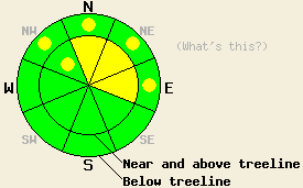
Near and above treeline MODERATE avalanche danger exists on the NW-N-NE-E aspects 35 degrees and steeper. Below treeline pockets of MODERATE danger exist on the NW-N-NE-E aspects on slopes steeper than 35 degrees. |
|
|
|
The cold low pressure system over the area should keep temperatures well below normal today with highs in the mid to upper 20's. This low pressure should also allow some clouds and scattered snow showers to continue over the mountains today. The forecast calls for very little actual accumulation. The winds should remain light through tonight before increasing ahead of the next low pressure during the day tomorrow. By tomorrow afternoon the winds should reach 30-55 mph over the crest with gusts over 100 mph. This next system also should push warmer air into the region ahead of it tomorrow and bring daytime highs into the mid to upper 30's. Some light precipitation could start tomorrow afternoon.
Observations from Donner Peak (Donner Summit area), Silver Peak (Pole Creek area), and Becker Peak (Echo Summit area) showed that several natural point-release avalanches occurred across the forecast area yesterday as the cold, light snow from Tuesday night sluffed away from the heavier layer of snow that fell during the day on Tuesday. On Becker Peak, some small soft slab avalanches also occurred due to failure at this interface (photos). In all three of these areas the slides occurred on N-NE facing, 38-40 degree slopes. Some skier-triggered sluffs released on similar test slopes in these areas, as well. The new snow did not exhibit many slab characteristics in these areas. Snowpit data on Silver Peak and Donner Peak indicated that the new snow has bonded well to the old crusts below it. On Silver Peak, while the snow on the northerly aspects remained light and soft, thin sun crusts started to form on the the E-SE and W aspects as soon as the sun hit the slopes. Expect to see a mix of thin breakable crusts and soft snow on these aspects today. Remote sensors show 3-5 inches of settlement and consolidation occurred in the new snow since yesterday morning at 6 am.
Avalanche concerns: Soft Slabs and Wind Slabs
As the cold, light new snow settles and bonds to itself, it will gain strength. It will also become more slab-like. In most areas, as this upper layer of snow gains strength, the storm-snow-weaknesses (grauple layers and density changes) near the base of it should also gain strength and should be able to support the snow above them. However, in some areas the upper layer of snow could gain strength faster than the storm-snow-weaknesses creating a slab on top of a weak layer. This combination could result in some human triggered avalanche activity today. The most likely areas where these kinds of avalanches could occur will be on NW-N-NE-E aspects in near and above treeline terrain in areas where wind loading has occurred and soft wind slabs formed during the storm. However, these kinds of avalanches will be possible on pockets of terrain at lower elevations as well. Careful snowpack observations can help determine where slabs have formed and where they have not. The best recreation and safest conditions will be on slopes where slabs have not formed and the snow remains soft and light.
Near and above treeline MODERATE avalanche danger exists on the NW-N-NE-E aspects 35 degrees and steeper. Below treeline pockets of MODERATE danger exist on the NW-N-NE-E aspects on slopes steeper than 35 degrees.
| 0600 temperature: | 12 deg. F. |
| Max. temperature in the last 24 hours: | 24 deg. F. |
| Average wind direction during the last 24 hours: | Southwest until 7 pm yesterday becoming variable after that. |
| Average wind speed during the last 24 hours: | Southwest: 20-30 mph | Variable: 5-10 mph |
| Maximum wind gust in the last 24 hours: | 52 mph |
| New snowfall in the last 24 hours: | 0-3 inches |
| Total snow depth: | 103-155 inches |
For 7000-8000 ft: |
|||
| Thursday: | Thursday Night: | Friday: | |
| Weather: | Mostly cloudy with a few isolated snow showers. | Mostly cloudy in the evening then becoming partly cloudy. | Mostly cloudy becoming cloudy with a 50% chance of snow showers in the afternoon. |
| Temperatures: | 22-29 deg. F. | 13-20 deg. F. | 32-39 deg. F. |
| Wind direction: | West | West | Southwest |
| Wind speed: | 10-15 mph | 10-15 mph decreasing after midnight | 10-20 mph with gusts to 35 mph increasing to 20 -30 mph with gusts to 55 mph |
| Expected snowfall: | trace to .5 in. | O in. | up to 1 in. |
For 8000-9000 ft: |
|||
| Thursday: | Thursday Night: | Friday: | |
| Weather: | Mostly cloudy with a few isolated snow showers. | Mostly cloudy in the evening then becoming partly cloudy. | Mostly cloudy becoming cloudy with a 60% chance of snow showers in the afternoon. |
| Temperatures: | 20-26 deg. F. | 11-18 deg. F. | 28-35 deg. F. |
| Wind direction: | West | West | West shifting to southwest in the afternoon |
| Wind speed: | 15-25 mph with gusts to 35 mph | 10-20 mph with gusts to 40 mph decreasing to gusts to 30 mph after midnight | 20-30 mph with gusts to 70 mph increasing to 30-55 mph with gusts to 100 mph |
| Expected snowfall: | trace to .5 in. | O in. | up to 1 in. |


This website is owned and maintained by the non-profit arm of the Sierra Avalanche Center. Some of the content is updated by the USDA avalanche forecasters including the forecasts and some observational data. The USDA is not responsible for any advertising, fund-raising events/information, or sponsorship information, or other content not related to the forecasts and the data pertaining to the forecasts.

