In partnership with: 
|
April 3, 2010 at 7:00 am |
|
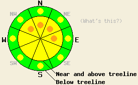
Near and above treeline pockets of CONSIDERABLE avalanche danger exist on the wind-loaded, NW-N-NE-E aspects 35 degrees and steeper with MODERATE avalanche danger on the other aspects. Below treeline pockets of MODERATE avalanche danger exist on all aspects on slopes steeper than 35 degrees. |
|
|
|
The snowfall and winds started earlier than forecasted yesterday with 4-6 inches of heavy, 18-22% density snow accumulating before 6pm and winds averaging between 40 and 100 mph along the ridgetops starting at 9am. Overnight, another 1-2 inches of snow accumulated, and the winds remained strong out of the southwest. By 10 pm most of the snowfall had ended. This morning the winds have started to decrease into the 30's as the low pressure departs the area. Today the winds should continue to decrease before picking back up tomorrow as another strong, cold low pressure approaches the region. Some isolated snow showers could linger over the Sierra today as well. By tomorrow afternoon expect more widespread snowfall to start again as the next storm hits the area.
Avalanche activity due to failure of wind slabs formed by yesterday's strong southwest winds occurred on Talking Mountain (Echo Summit area - photo), on Castle Peak (Donner Summit area - photo), and on Tamarack Peak (Mt. Rose area - video and photos). In all three of these areas, the slides occurred on 36-44 degree, N-NE facing, wind-loaded slopes in near and above treeline terrain. The slabs ranged from 4 inches to 16 inches in thickness. Debris from these slides ran downhill for anywhere from 60 ft. to 200 ft. The interface between the soft snow that fell on March 30th and the stiff, newly-formed wind slabs served as the weak layer for all of these slides. On Castle Peak and on Talking Mountain these slides failed naturally. On Tamarack Peak a skier triggered the avalanches while standing 15-20 ft away in lower angle terrain on a ridgeline. Skier triggered shooting cracks occurred on Castle Peak and on Tamarack Peak as well.
Avalanche concern #1: Wind Slabs
New snow and strong winds yesterday and overnight created larger winds slabs and tender cornices on wind-loaded slopes over the last 24 hours. Human triggered avalanches involving these new wind slabs will be probable today. Some natural avalanches due to failure of these wind slabs will be possible in the most heavily wind-loaded areas as well. These stiff slabs could be triggered from lower angle slopes and could pull snow from those lower angle slopes down with them. The most likely areas for avalanches will be on wind-loaded NW-N-NE-E aspects in near and above treeline terrain. However, some unstable wind slabs could exist on lower elevation slopes due to the strong winds. Careful snowpack observations can help determine where slabs have formed and where they have not. The best recreation and safest conditions will be on slopes where slabs have not formed and the snow remains soft.
Avalanche concern #2: Storm snow instabilities
Yesterday's heavy storm snow sits on top of lighter older snow. In some areas this storm snow may not have bonded well to the snow from March 30th. Adding a person or a snowmobile to the snowpack may be enough to break the bonds at this interface today on slopes steeper than 35 degrees even in non-wind affected areas. Most of these avalanches should only involve the new snow and should have more soft slab characteristics. These types of instabilities will be most likely in steep open areas.
Near and above treeline pockets of CONSIDERABLE avalanche danger exist on the wind-loaded, NW-N-NE-E aspects 35 degrees and steeper with MODERATE avalanche danger on the other aspects. Below treeline pockets of MODERATE avalanche danger exist on all aspects on slopes steeper than 35 degrees.
| 0600 temperature: | 18 deg. F. |
| Max. temperature in the last 24 hours: | 26 deg. F. |
| Average wind direction during the last 24 hours: | Southwest |
| Average wind speed during the last 24 hours: | 55-65 mph |
| Maximum wind gust in the last 24 hours: | 137 mph |
| New snowfall in the last 24 hours: | 5-8 inches |
| Total snow depth: | 107-163 inches |
For 7000-8000 ft: |
|||
| Saturday: | Saturday Night: | Sunday: | |
| Weather: | Mostly cloudy with a 20% chance for isolated snow showers. | Mostly cloudy with a 20% chance of snow showers. | Snow likely |
| Temperatures: | 25-32 deg. F. | 17-23 deg. F. | 23-28 deg. F. |
| Wind direction: | Southwest | Southwest | Southwest |
| Wind speed: | 10-20 mph with gusts to 40 mph decreasing to 25 mph in the afternoon | 10-15 mph with gusts to 30 mph | 10-20 mph with gusts to 35 mph increasing to 20-30 mph with gusts to 60 mph |
| Expected snowfall: | trace in. | trace in. | up to 2 in. |
For 8000-9000 ft: |
|||
| Saturday: | Saturday Night: | Sunday: | |
| Weather: | Mostly cloudy with a 20% chance for isolated snow showers. | Mostly cloudy with a 20% chance of snow showers. | Snow likely |
| Temperatures: | 23-27 deg. F. | 10-17 deg. F. | 21-27 deg. F. |
| Wind direction: | Southwest | Southwest | Southwest |
| Wind speed: | 20-35 mph with gusts to 55 mph decreasing to 15-25 mph with gusts to 35 in the afternoon | 20-30 mph with gusts to 50 mph | 15-25 mph with gusts to 50 mph increasing to 25-40 mph with gusts to 70 mph in the afternoon |
| Expected snowfall: | trace in. | trace in. | up to 2 in. |


This website is owned and maintained by the non-profit arm of the Sierra Avalanche Center. Some of the content is updated by the USDA avalanche forecasters including the forecasts and some observational data. The USDA is not responsible for any advertising, fund-raising events/information, or sponsorship information, or other content not related to the forecasts and the data pertaining to the forecasts.

