In partnership with: 
|
April 5, 2010 at 6:45 am |
|
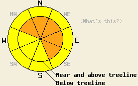
Near and above treeline, avalanche danger is CONSIDERABLE on NW-N-NE-E-SE aspects, 35 degrees and steeper. Below treeline, avalanche danger is MODERATE in open areas 35 degrees and steeper. Large human triggered avalanches should be expected in steep wind loaded terrain. |
|
|
|
The storm system currently affecting the forecast area is winding down this morning. Storm totals above 7,000' thus far measure 16 to 20 inches along the Sierra Crest and 11 to 13 inches in the Carson Range. Most of the new snow accumulated within the last 15 hours. Cloudy to mostly cloudy skies with ongoing snow showers are expected for today with an additional 1 to 4 inches of new snow accumulation. Air temperatures this morning above 8,000' are in the mid to upper teens with only a few degrees of warming expected during the day. Ridgetop winds have decreased from strong to moderate in speed this morning and are forecast to continue at moderate speed out of the southwest to west.
Observations made yesterday on Silver Peak (Pole Creek area) indicated that the existing snowpack was in good condition to handle new snow loading. Informal observations found no evidence of instability in the area. Snowpit data collected near treeline at 8,020' on a N aspect 34 degree slope yielded no further evidence of instability (pit profile). Light snowfall was noted in the area at 10:30am with some graupel mixed in with the new snow at the beginning of the storm. Ridgetop winds exceeded forecast speeds and blowing snow was noted during gusty periods. Despite the wind transport of old and new snow, no new slab formation was observed in the area prior to 11:30am.
Data collected this morning from the Alpine Meadows Ski Area snow study plot at 6,900' revealed an average new snow density of 7%, several clean shears within the new snow, and widespread fracture propagation.
Avalanche concerns:
Avalanche concerns for today focus on new snow. The greatest period of instability and best window for natural avalanche activity already occurred last night. Evidence of recent natural avalanche activity is expected in the backcountry today. Isolated natural avalanche activity will remain possible through today in areas that receive the upper end of forecast snowfall amounts. Human triggered avalanche activity is expected during the day today due to weaknesses within the new snow combined with ongoing winds and snowfall. The greatest areas of instability are expected to occur near and above treeline in wind loaded areas on NW-N-NE-E-SE aspects. Wind slabs over 3 feet deep are expected in wind loaded areas. Large human triggered avalanches should be expected in steep wind loaded terrain. Human triggered avalanche activity should also be anticipated in steep open areas below treeline. In extremely isolated areas, deep slab avalanche activity involving the recent old snow layers up to several feet below the old/new snow interface is not out of the realm of possibility.
Near and above treeline, avalanche danger is CONSIDERABLE on NW-N-NE-E-SE aspects, 35 degrees and steeper. Below treeline, avalanche danger is MODERATE in open areas 35 degrees and steeper. Large human triggered avalanches should be expected in steep wind loaded terrain.
| 0600 temperature: | 13 to 18 deg. F. |
| Max. temperature in the last 24 hours: | 22 to 27 deg. F. |
| Average wind direction during the last 24 hours: | Southwest |
| Average wind speed during the last 24 hours: | 50 mph |
| Maximum wind gust in the last 24 hours: | 95 mph |
| New snowfall in the last 24 hours: | 11 to 20 inches |
| Total snow depth: | 119 to 166 inches |
For 7000-8000 ft: |
|||
| Monday: | Monday Night: | Tuesday: | |
| Weather: | Cloudy to mostly cloudy skies with snow in the morning. Numerous snow showers in the afternoon. | Mostly cloudy skies in the evening becoming partly cloudy. Slight chance of snow showers. | Partly cloudy skies. |
| Temperatures: | 18 to 25 deg. F. | 15 to 20 deg. F. | 25 to 35 deg. F. |
| Wind direction: | W | W | W |
| Wind speed: | 15 to 25 mph with gusts to 50 mph. Gusts decreasing to 35 mph in the afternoon. | 10 to 15 mph with gusts to 30 mph. Winds decreasing to around 5 to 10 mph after midnight. | Around 10 mph in the morning becoming light. |
| Expected snowfall: | 1 to 3 in. | 0 to trace in. | O in. |
For 8000-9000 ft: |
|||
| Monday: | Monday Night: | Tuesday: | |
| Weather: | Cloudy to mostly cloudy skies with snow in the morning. Numerous snow showers in the afternoon. | Mostly cloudy skies in the evening becoming partly cloudy. Slight chance of snow showers. | Partly cloudy skies. |
| Temperatures: | 15 to 20 deg. F. | 10 to 20 deg. F. | 25 to 30 deg. F. |
| Wind direction: | W | W | N |
| Wind speed: | 20 to 30 mph with gusts to 50 mph. | 10 to 20 mph with gusts to 30 mph. Winds decreasing to 5 to 10 mph after midnight. | Up to 15 mph with gusts to 30 mph. |
| Expected snowfall: | 1 to 4 in. | 0 to trace in. | O in. |


This website is owned and maintained by the non-profit arm of the Sierra Avalanche Center. Some of the content is updated by the USDA avalanche forecasters including the forecasts and some observational data. The USDA is not responsible for any advertising, fund-raising events/information, or sponsorship information, or other content not related to the forecasts and the data pertaining to the forecasts.

