In partnership with: 
|
April 6, 2010 at 6:42 am |
|
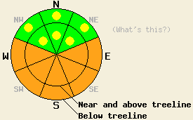
Avalanche danger is CONSIDERABLE at all elevations on E-SE-S-SW-W aspects 35 degrees and steeper due to warming instability. Pockets of MODERATE danger linger on NW-N-NE aspects 37 degrees and steeper both above and below treeline due to recent storm snow instability. |
|
|
|
High pressure is building over the forecast area. Sunny skies, above freezing air temperatures, and light to moderate speed ridgetop winds are expected for today. An additional 1 to 7 inches of new snow accumulated across the region due to snow showers over the past 24 hours. Air temperatures this morning above 8,000' are in the mid teens and are expected to warm into the upper 20s to mid 30s today. Ridgetop winds have shifted to the west this morning and are expected to shift to the northwest as the day progresses.
Observations made yesterday showed an inconsistent presence and absence of slab instability. The largest avalanche reported occurred on Mt. Lola (Independence Lake area) in response to a natural trigger at 8,200' in a large open area in near treeline terrain on a SE aspect. The avalanche was viewed from across the valley so exact dimensions are unknown, but the crown is estimated at 3 to 4 feet deep and 300 to 400' wide with a slope angle near 45 degrees (photo). A small snowboarder triggered avalanche was reported on Powderhouse Peak (Luther Pass area) at 9,040' in below treeline terrain on a NW aspect 39 degree slope. The crown was 16 inches deep and about 8 feet wide. The weak layer was noted as stellar crystals within the new snow (photos, more info). On Carpenter Ridge (Independence Lake area) intentional skier triggered collapse of refrigerator size cornice sections produced mostly sluffing in near treeline terrain on NW-N-NE aspects between 8,500' and 8,900'. In very isolated areas slab failure occurred 4 to 8 inches deep with propagation less than 12 feet (photos, more info). Near Frog Lake (Carson Pass area) a small natural avalanche was noted at 8,840' in near treeline terrain on an E aspect 40 degree slope. The crown measured 4 inches deep, 65 feet wide, and ran 165 feet down slope. Snowpit data collected adjacent to the avalanche indicated that the weak layer was a density change within the new snow (pit profile, more info). No other evidence of fracture propagation was observed in this area.
Avalanche concern #1: Warming instability
The combination of new snow, continued wind loading by NW winds, April solar radiation, and near to above freezing air temperatures will keep natural avalanches possible today and skier triggered avalanches likely today. This warming instability is expected to form in open sun exposed areas at all elevations on E-SE-S-SW-W aspects as the day progresses. Snowpack failure is expected to occur within the the recent new snow. Avalanches large enough to bury or injure a person are expected, especially during the late morning through afternoon hours.
Avalanche concern #2: Storm snow
Lingering pockets of instability are expected both above and below treeline on NW-N-NE aspects in steep terrain. Any snowpack failure is expected to occur within the new snow. Human triggered avalanches are most likely to occur today on convex slopes and in complex, wind affected terrain.
Avalanche danger is CONSIDERABLE at all elevations on E-SE-S-SW-W aspects 35 degrees and steeper due to warming instability. Pockets of MODERATE danger linger on NW-N-NE aspects 37 degrees and steeper both above and below treeline due to recent storm snow instability.
| 0600 temperature: | 13 to 16 deg. F. |
| Max. temperature in the last 24 hours: | 24 to 28 deg. F. |
| Average wind direction during the last 24 hours: | Southwest |
| Average wind speed during the last 24 hours: | 40 mph |
| Maximum wind gust in the last 24 hours: | 89 mph |
| New snowfall in the last 24 hours: | 1 to 7 inches |
| Total snow depth: | 116 to 164 inches |
For 7000-8000 ft: |
|||
| Tuesday: | Tuesday Night: | Wednesday: | |
| Weather: | Partly cloudy skies in the morning becoming sunny. | Clear skies. | Sunny skies. |
| Temperatures: | 32 to 40 deg. F. | 25 to 30 deg. F. | 43 to 50 deg. F. |
| Wind direction: | NW | E | E |
| Wind speed: | Around 10 mph. | 10 to 15 mph with gusts to 25 mph. | 10 to 15 mph. |
| Expected snowfall: | O in. | O in. | O in. |
For 8000-9000 ft: |
|||
| Tuesday: | Tuesday Night: | Wednesday: | |
| Weather: | Partly cloudy skies in the morning becoming sunny. | Clear skies. | Sunny skies. |
| Temperatures: | 25 to 35 deg. F. | 20 to 25 deg. F. | 38 to 45 deg. F. |
| Wind direction: | NW | E | E |
| Wind speed: | 10 to 15 mph with gusts to 30 mph. | 10 to 20 mph with gusts to 30 mph. | 10 to 15 mph with gusts up to 25 mph in the afternoon. |
| Expected snowfall: | O in. | O in. | O in. |


This website is owned and maintained by the non-profit arm of the Sierra Avalanche Center. Some of the content is updated by the USDA avalanche forecasters including the forecasts and some observational data. The USDA is not responsible for any advertising, fund-raising events/information, or sponsorship information, or other content not related to the forecasts and the data pertaining to the forecasts.

