In partnership with: 
|
April 7, 2010 at 7:00 am |
|
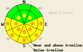
Pockets of CONSIDERABLE avalanche danger will form at all elevations on E-SE-S-SW-W aspects 35 degrees and steeper due to daytime warming. Small isolated pockets of MODERATE danger linger on NW-N-NE aspects 37 degrees and steeper near and above treeline in complex wind-loaded terrain. |
|
|
|
Sunny skies and warmer temperatures should continue today due to a high pressure ridge over the area. The east winds should start to decrease this morning and should shift back to the southwest tonight as a weak low pressure system approaches the northern part of the Sierra. This low pressure should bring slight cooler temperatures, a few clouds, and stronger southwest winds to the forecast area tomorrow.
Several natural and skier-triggered point release avalanches occurred in the Mt. Rose backcountry and on Castle Peak yesterday due to the rapid warming of the snowpack by the intense April sunshine. These slides occurred on 35-40 degree, E-SE-S-SW facing, sun-exposed slopes (photo from Rose Knob Peak, photo from Incline Lake Peak). These slides started to move between 10 am and 11 am and continued to release through the day. By 10 am, 2-3 inches of sun-affected, wet, heavy snow existed on the surface at 9700' on Rose Knob Peak. These aspects should have refrozen well last night due to the combination of overnight temperatures below freezing and clear skies. On the more northerly aspects, the snow remained soft and cold in most areas. Most ski cuts, snowmobile cuts, and dropping oven to refrigerator sized cornice pieces onto wind loaded N-NE facing slopes in the Castle Peak area and in the Rose Knob Peak area did not result in significant signs of instability. In Rose Knob Peak area, one isolated, 43 degree, NE facing test slope did release a small, shallow wind slab after a skier jumped on the slope several times (photo). Ski cuts on the similar slopes adjacent to this slope did not produce any results. Snowpit data and layer bonding tests on northerly aspects on Castle Peak, Rose Knob Peak, and Incline Lake Peak show a strengthening snowpack. Expect to find soft snow on the shaded northerly aspects today with some breakable crusts on the sun exposed northerly aspects. The sun exposed E-SE-S-SW-W aspects should have wet snow on them once the sun hits them this morning.
Avalanche concern #1: Warming instability
The intense April sunshine and warm air temperatures will heat the snowpack up on the sun-exposed E-SE-S-SW-W aspects again today. The new snow has not had enough time to adjust to this rapid warming, and instabilities will from again today as a result of this warming. Strong easterly winds overnight have also added new, cold snow to the S-SW-W aspects. On these newly, wind-loaded slopes, avalanche activity due to daytime warming should be even more widespread. Natural avalanches will remain possible on the most sun-exposed and newly wind-loaded slopes. Skier triggered avalanches will remain likely. Roller balls and point-release avalanches should comprise most of the avalanches activity today; however, some slab avalanches could be possible as well. Avalanches large enough to bury or injure a person could occur today.
Avalanche concern #2: Storm snow
Last night's strong east winds and continued settlement in the recent snow will have helped to strengthen the snowpack and unload some of the previously wind-loaded slopes. However, a few small isolated pockets of instability may still linger in near and above treeline on NW-N-NE aspects in steep, complex, rocky terrain. Convex slopes and unsupported slopes in complex, wind affected terrain will hold the best chances for these types of instability.
Pockets of CONSIDERABLE avalanche danger will form at all elevations on E-SE-S-SW-W aspects 35 degrees and steeper due to daytime warming. Small isolated pockets of MODERATE danger linger on NW-N-NE aspects 37 degrees and steeper near and above treeline in complex wind-loaded terrain.
| 0600 temperature: | 23 deg. F. |
| Max. temperature in the last 24 hours: | 34-39 deg. F. |
| Average wind direction during the last 24 hours: | East |
| Average wind speed during the last 24 hours: | 20-30 mph |
| Maximum wind gust in the last 24 hours: | 56 mph |
| New snowfall in the last 24 hours: | O inches |
| Total snow depth: | 115-160 inches |
For 7000-8000 ft: |
|||
| Wednesday: | Wednesday Night: | Thursday: | |
| Weather: | Sunny | Partly cloudy | Partly cloudy |
| Temperatures: | 40-48 deg. F. | 24-37 deg. F. | 38-48 deg. F. |
| Wind direction: | East | Southeast shifting to southwest | Southwest |
| Wind speed: | 10-20 mph | 10 mph | 10-20 mph with gusts to 35 mph |
| Expected snowfall: | O in. | O in. | O in. |
For 8000-9000 ft: |
|||
| Wednesday: | Wednesday Night: | Thursday: | |
| Weather: | Sunny | Partly cloudy | Partly cloudy |
| Temperatures: | 35-40 deg. F. | 28-37 deg. F. | 30-38 deg. F. |
| Wind direction: | East | Southeast shifting to southwest | Southwest |
| Wind speed: | 20-35 mph with gusts to 40 mph decreasing to 10-15 with gusts to 25 mph by mid morning | 10 mph with gusts to 25 mph | 10-15 mph with gusts to 25 mph increasing to 20-30 mph with gusts to 45 mph |
| Expected snowfall: | O in. | O in. | O in. |


This website is owned and maintained by the non-profit arm of the Sierra Avalanche Center. Some of the content is updated by the USDA avalanche forecasters including the forecasts and some observational data. The USDA is not responsible for any advertising, fund-raising events/information, or sponsorship information, or other content not related to the forecasts and the data pertaining to the forecasts.

