In partnership with: 
|
April 8, 2010 at 6:54 am |
|
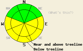
This morning the avalanche danger is LOW. The avalanche danger will quickly increase to MODERATE at all elevations on E-SE-S-SW-W aspects 35 degrees and steeper due to daytime warming. |
|
|
|
Yesterday afternoon, the winds shifted to the southwest due to a low pressure system moving into the Pacific Northwest. These moderate southwest winds should continue this morning before they start to decrease this afternoon. A small cold front should start to move through the Sierra today and tonight bringing a few clouds and slightly cooler temperatures to the area. By tomorrow the clouds should start to clear and the winds should decrease as the front moves eastward.
Yesterday, more point-release avalanches occurred on sun-exposed E-SE-S facing slopes. On Jake's Peak some of these slides occurred naturally and some were skier triggered (photos). Some similar wet, point-release avalanches also occurred in this area on Tuesday. The intense April sun softened the snow surface on the E-SE-S aspects before noon and left several inches of sticky, heavy, wet snow on these aspects. The snow on these aspects has not gone through enough melt-freeze cycles to become good corn snow yet. On the more northerly aspects, the sun had left a thin, breakable crust on the snow surface up to 8800'. In areas that received sun on these aspects yesterday, this crust melted leaving sticky, wet snow on the surface. On the shaded northerly aspects that have not seen very much sunshine pockets of the soft, dry snow remain. Remote sensors between 6800' and 8800' indicate that the overnight lows remained within a few degrees of freezing. Some sensors reported slightly below freezing temperatures and some reported temperatures slightly above freezing. These temperatures combined with a clear night sky that allowed the snowpack to radiate heat into the atmosphere will have allowed a decent refreeze to occur in the snowpack.
Avalanche concerns: Warming instability
Today, the combination of sunny skies and daytime highs well above freezing will allow the snowpack to warm up enough for wet-snow instabilities to form on the sun-exposed E-SE-S-SW-W aspects again. Slightly cooler daytime highs, some cloud cover, and the fact that the snow has gone through a few days of melt-freeze cycles will all work to make today's wet-snow instabilities less widespread than yesterday's or Tuesday's. Roller balls, pinwheels, and point-release avalanches should comprise most of the instabilities today; however, some slab avalanches could still be possible. Avalanches large enough to bury or injure a person remain possible today.
This morning the avalanche danger is LOW. The avalanche danger will quickly increase to MODERATE at all elevations on E-SE-S-SW-W aspects 35 degrees and steeper due to daytime warming.
| 0600 temperature: | 29-33 deg. F. |
| Max. temperature in the last 24 hours: | 39-49 deg. F. |
| Average wind direction during the last 24 hours: | East shifting to the southwest around 4pm yesterday |
| Average wind speed during the last 24 hours: | 20-25 mph |
| Maximum wind gust in the last 24 hours: | 47 mph |
| New snowfall in the last 24 hours: | O inches |
| Total snow depth: | 110-157 inches |
For 7000-8000 ft: |
|||
| Thursday: | Thursday Night: | Friday: | |
| Weather: | Partly cloudy | Partly cloudy | Partly cloudy in the morning becoming sunny in the afternoon. |
| Temperatures: | 38-48 deg. F. | 28-32 deg. F. | 38-46 deg. F. |
| Wind direction: | West to southwest | West shifting to the east | South |
| Wind speed: | 10-20 mph with gusts to 35 mph | 10-15 mph with gusts to 30 mph | 10 mph |
| Expected snowfall: | O in. | O in. | O in. |
For 8000-9000 ft: |
|||
| Thursday: | Thursday Night: | Friday: | |
| Weather: | Partly cloudy | Partly cloudy | Partly cloudy in the morning becoming sunny in the afternoon. |
| Temperatures: | 35-40 deg. F. | 25-32 deg. F. | 32-40 deg. F. |
| Wind direction: | West to southwest | West shifting to southeast | South |
| Wind speed: | 20-30 mph with gusts to 50 mph | 15-25 mph with gusts to 45 mph decreasing to 10 mph with gusts to 25 mph | 10-15 mph with gusts to 25 mph |
| Expected snowfall: | O in. | O in. | O in. |


This website is owned and maintained by the non-profit arm of the Sierra Avalanche Center. Some of the content is updated by the USDA avalanche forecasters including the forecasts and some observational data. The USDA is not responsible for any advertising, fund-raising events/information, or sponsorship information, or other content not related to the forecasts and the data pertaining to the forecasts.

