In partnership with: 
|
April 10, 2010 at 6:47 am |
|
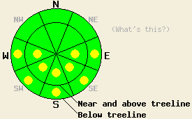
Avalanche danger is LOW with pockets of MODERATE danger in open areas at all elevations on E-SE-S-SW-W aspects 37 degrees and steeper. |
|
|
|
Another winter storm is approaching the forecast area. Many details associated with the system remain unclear, especially concerning timing and snowfall amounts over the next few days. Cloud cover increased yesterday and overnight in the northern portion of the forecast area. Ridgetop winds have shifted from the east to the southwest this morning. Winds are expected to increase in speed as the day progresses. Air temperatures above 8,000' are in the low 30s this morning and are expected to warm into the mid 30s to low 40s as the day progresses.
Observations made yesterday on Castle Peak (Donner Summit area) reveled melt freeze conditions on all aspects below 8,600'. Natural wet loose avalanche activity was noted to have occurred as recently as Thursday in near treeline terrain at 7,880' on a SE aspect 50 degree slope (photos). By 10:30 am, enough melting of surface snow had occurred to create many areas on E-SE aspects where the snow surface no longer supported the weight of a skier. On S-SW-W aspects, the snow surface remained supportable for another hour or so. On NW-N-NE aspects, the snow surface remained frozen into the afternoon hours. On all aspects, once the frozen surface melted and became unsupportable, several inches of soft wet snow existed on top of cold unconsolidated snow. The surface snow has yet to undergo enough melt freeze cycles to form the proper crust and grain size needed for true supportable corn conditions.
Avalanche concerns: Warming instability
Avalanche concerns for today remain focused on warming instability. The combination of near to above freezing air temperatures last night and increasing cloud cover is expected to have allowed for only a weak refreeze of surface snow, especially in the northern half of the forecast area. A better refreeze is expected to have occurred in the southern half of the forecast area. In areas where a weak refreeze occurred, increasing avalanche danger will occur quickly this morning with human triggered avalanches possible in isolated areas during the morning hours. The greatest areas for potential wet snow instability this morning will exist on E-SE aspects between 6,500' and 8,000'. Pockets of instability will spread to S-SW-W aspects and to all elevations in response to daytime warming, especially in areas that receive more sun today. Wet loose avalanches remain the most likely form of instability, however wet slab avalanches are possible in isolated areas. Increasing winds today may keep the snow surface colder in wind exposed areas along ridgelines. An abrupt increase in snow surface melting is likely just below these ridgelines in more wind protected areas.
Avalanche danger is LOW with pockets of MODERATE danger in open areas at all elevations on E-SE-S-SW-W aspects 37 degrees and steeper.
| 0600 temperature: | 30 to 32 deg. F. |
| Max. temperature in the last 24 hours: | 43 to 46 deg. F. |
| Average wind direction during the last 24 hours: | East |
| Average wind speed during the last 24 hours: | 21 mph |
| Maximum wind gust in the last 24 hours: | 30 mph |
| New snowfall in the last 24 hours: | O inches |
| Total snow depth: | 105 to 152 inches |
For 7000-8000 ft: |
|||
| Saturday: | Saturday Night: | Sunday: | |
| Weather: | Mostly cloudy skies with isolated snow showers in the afternoon. | Cloudy skies with isolated snow showers. | Cloudy skies with a chance of snow. |
| Temperatures: | 40 to 47 deg. F. | 25 to 30 deg. F. | 34 to 40 deg. F. |
| Wind direction: | S to SW | S | S |
| Wind speed: | 10 to 15 mph with gusts to 30 mph. Winds increasing to 15 to 25 mph with gusts to 40 mph in the afternoon. | 20 to 30 mph with gusts to 40 mph. | 25 to 30 mph with gusts to 50 mph. |
| Expected snowfall: | 0 to trace in. | 0 to trace in. | Up to 2 in. |
For 8000-9000 ft: |
|||
| Saturday: | Saturday Night: | Sunday: | |
| Weather: | Mostly cloudy skies with isolated snow showers in the afternoon. | Cloudy skies with isolated snow showers. | Cloudy skies with a chance of snow. |
| Temperatures: | 36 to 42 deg. F. | 20 to 25 deg. F. | 30 to 35 deg. F. |
| Wind direction: | S to SW | S | S |
| Wind speed: | 20 to 30 mph with gusts to 50 mph. Winds increasing to 30 to 45 mph with gusts to 65 mph in the afternoon. | 40 to 65 mph with gusts to 85 mph. | 60 to 80 mph with gusts to 100 mph. |
| Expected snowfall: | 0 to trace in. | 0 to trace in. | Up to 4 in. |


This website is owned and maintained by the non-profit arm of the Sierra Avalanche Center. Some of the content is updated by the USDA avalanche forecasters including the forecasts and some observational data. The USDA is not responsible for any advertising, fund-raising events/information, or sponsorship information, or other content not related to the forecasts and the data pertaining to the forecasts.

