In partnership with: 
|
April 12, 2010 at 6:40 am |
|
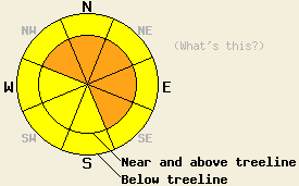
South of Hwy 50 along the Sierra Crest, avalanche danger near and above treeline is CONSIDERABLE on NW-N-NE-E-SE aspects 35 degrees and steeper. Below treeline, avalanche danger is MODERATE on all aspects, 35 degrees and steeper. North of Hwy 50 along the Sierra Crest and for the Carson Range, avalanche danger near and above treeline is MODERATE on NW-N-NE-E-SE aspects 35 degrees and steeper. Below treeline, avalanche danger is LOW with pockets of MODERATE danger on all aspects, 35 degrees and steeper. |
|
|
|
The storm system that passed through the forecast area yesterday afternoon and overnight and is tapering off this morning. The greatest snowfall amounts occurred along the Sierra Crest south of Hwy 50 where storm totals are running 10 to 13 inches this morning. North of Hwy 50 and in the Carson Range, 3 to 8 inches of new snow has accumulated. Continued snow showers today are forecast to provide an additional 2 to 6 inches of new snow. Ridgetop winds remain moderate to strong in speed out of the south to southwest this morning. Ridgetop winds are forecast to remain moderate in speed out of the southwest through today. Air temperatures this morning above 8,000' are in the upper teens to low 20s and are forecast to remain in the 20s today.
Observations made yesterday on Rose Knob Peak (Mount Rose area) revealed that melt freeze surface crusts remained frozen on all aspects above 7,600' at 1 pm. Melting of surface crusts occurred below 7,600' on all aspects under the influence of above freezing air temperatures. For the majority of avalanche start zones, new snow was deposited onto crust surfaces that were in a frozen state. This is expected to have created a weaker bond of new snow to the old snow surface in areas above 7,600'. Below 7,600', better bonding at the old/new snow interface is expected as new snow was deposited onto a refreezing crust.
Avalanche concerns: Storm snow
Avalanche concerns for today focus on storm snow. The best window for natural avalanche activity already occurred last night, but isolated natural avalanche activity may occur today in wind loaded areas that receive the upper end of forecast snowfall amounts for today. Widespread human triggered avalanches are expected today, especially along the Sierra Crest south of Hwy 50 where the greatest new snow amounts exist. For all areas, any snowpack failure that occurs today is expected at or above the height of the uppermost crust layer. Wind loaded areas near and above treeline are expected to hold newly formed wind slabs mainly on NW-N-NE-E-SE aspects. Below treeline, slabs may exist in open wind affected areas. In non wind affected areas, large human triggered loose snow avalanches may occur, especially in steep terrain above 7,600' where poor bonding to the crust at the bottom of the storm snow is expected. This crust will act as an efficient bed surface and allow for long running avalanches to occur.
South of Hwy 50 along the Sierra Crest, avalanche danger near and above treeline is CONSIDERABLE on NW-N-NE-E-SE aspects 35 degrees and steeper. Below treeline, avalanche danger is MODERATE on all aspects, 35 degrees and steeper. North of Hwy 50 along the Sierra Crest and for the Carson Range, avalanche danger near and above treeline is MODERATE on NW-N-NE-E-SE aspects 35 degrees and steeper. Below treeline, avalanche danger is LOW with pockets of MODERATE danger on all aspects, 35 degrees and steeper.
| 0600 temperature: | 19 to 22 deg. F. |
| Max. temperature in the last 24 hours: | 25 to 36 deg. F. |
| Average wind direction during the last 24 hours: | South southwest |
| Average wind speed during the last 24 hours: | 40 mph |
| Maximum wind gust in the last 24 hours: | 86 mph |
| New snowfall in the last 24 hours: | 3 to 13 inches |
| Total snow depth: | 107 to 156 inches |
For 7000-8000 ft: |
|||
| Monday: | Monday Night: | Tuesday: | |
| Weather: | Mostly cloudy to cloudy skies with snow showers. | Mostly cloudy skies with scattered snow showers. | Mostly cloudy skies with a slight chance of snow showers. |
| Temperatures: | 25 to 32 deg. F. | 18 to 25 deg. F. | 33 to 40 deg. F. |
| Wind direction: | SW | SW | SW |
| Wind speed: | 15 to 25 mph with gusts to 40 mph. | 10 to 15 mph with gusts to 30 mph in the evening. | Around 10 mph. |
| Expected snowfall: | 2 to 6 in. | 0 to trace in. | 0 to trace in. |
For 8000-9000 ft: |
|||
| Monday: | Monday Night: | Tuesday: | |
| Weather: | Mostly cloudy to cloudy skies with snow showers. | Mostly cloudy skies with scattered snow showers. | Mostly cloudy skies with a slight chance of snow showers. |
| Temperatures: | 20 to 28 deg. F. | 11 to 18 deg. F. | 28 to 35 deg. F. |
| Wind direction: | SW | SW | SW |
| Wind speed: | 20 to 35 mph with gusts to 55 mph. | 15 to 25 mph with gusts to 45 mph. Winds decreasing to 10 to 15 mph with gusts to 30 mph after midnight. | Around 10 mph. |
| Expected snowfall: | 2 to 6 in. | 0 to trace in. | 0 to trace in. |


This website is owned and maintained by the non-profit arm of the Sierra Avalanche Center. Some of the content is updated by the USDA avalanche forecasters including the forecasts and some observational data. The USDA is not responsible for any advertising, fund-raising events/information, or sponsorship information, or other content not related to the forecasts and the data pertaining to the forecasts.

