In partnership with: 
|
April 14, 2010 at 7:00 am |
|
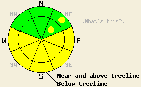
MODERATE avalanche danger will form on E-SE-S-SW-W aspects at all elevations on slopes 35 degrees and steeper due to daytime warming. Isolated pockets of MODERATE avalanche danger may also form on some NE aspects that warm up today. If slopes receive more sunshine than forecasted the avalanche danger may increase. |
|
|
|
A low pressure near the Pacific Northwest should cause the southerly winds to increase and push some clouds into the forecast area this afternoon. Enough moisture should accompany these clouds for a slight chance of some afternoon snow showers. If the area does get any showers there should not be enough snow for any significant accumulation. The weather should start to clear back up tonight and warmer temperatures should return to the region tomorrow with daytime highs forecasted to reach into the mid 40's above 7000'.
Yesterday on Janine's Peak and on the approach to and from Janine's, several skier-triggered and cornice-triggered loose-snow avalanches occurred on 40 degree, sun-exposed, NE facing slopes up to 9400' (photos). On Mt. Tallac similar skier-triggered sluffs occurred on E-SE aspects on slopes steeper than 35 degrees. Some drier, snowboarder-triggered sluffs also occurred on a steep N-NE aspect above 8500'. Several other natural point-release avalanches had occurred either yesterday or the day before on E-SE-S aspects in this area. These sluffs did not entrain enough snow to bury a person; however, they could have knocked someone off his/her feet or pushed them into an area that they did not want to go. Snowpit tests and ski cuts on more northerly aspects on Mt. Tallac showed mostly cold, soft snow on northerly slopes above 8000'. Layer bonding tests indicate that the bonding between the recent snow and the crusts below it and bonding within the recent snow has gotten stronger. On any slopes below 8500' that received sunshine yesterday, the snow quickly became wet and sticky by mid day.
Avalanche Concern #1: Warming Instabilities
With more sun and daytime highs above freezing, expect more wet-snow instabilities to form as a result of daytime warming. Today's increased cloud cover, increased winds, and the fact that the snow already experienced some warming during the last two days should help make these instabilities less widespread today. The E-SE-S-SW-W aspects will hold the best potential for these types of instabilities. However, wet snow instabilities could form on any slopes that receive significant sunshine including some of the NE aspects. These instabilities will become larger and more widespread if the region receives more sun than forecasted or temperatures climb higher than forecasted. Most of these warming instabilities should take the form of point-release avalanches and other surface instabilities; however, some slab avalanches may be possible as well.
MODERATE avalanche danger will form on E-SE-S-SW-W aspects at all elevations on slopes 35 degrees and steeper due to daytime warming. Isolated pockets of MODERATE avalanche danger may also form on some NE aspects that warm up today. If slopes receive more sunshine than forecasted the avalanche danger may increase.
| 0600 temperature: | 23 deg. F. |
| Max. temperature in the last 24 hours: | 33-39 deg. F. |
| Average wind direction during the last 24 hours: | Southwest shifting more to the south |
| Average wind speed during the last 24 hours: | 10-20 mph |
| Maximum wind gust in the last 24 hours: | 29 mph |
| New snowfall in the last 24 hours: | O inches |
| Total snow depth: | 107-157 inches |
For 7000-8000 ft: |
|||
| Wednesday: | Wednesday Night: | Thursday: | |
| Weather: | Partly cloudy in the morning becoming mostly cloudy in the afternoon. 20% chance of isolated snow showers in the afternoon. | Partly cloudy | Partly cloudy becoming mostly cloudy in the afternoon. |
| Temperatures: | 37-45 deg. F. | 20-27 deg. F. | 44-51 deg. F. |
| Wind direction: | South | Southwest | South |
| Wind speed: | 10-20 mph with gusts to 30 mph | 10-15 mph with gusts to 30 mph | 10 mph |
| Expected snowfall: | trace in. | O in. | O in. |
For 8000-9000 ft: |
|||
| Wednesday: | Wednesday Night: | Thursday: | |
| Weather: | Partly cloudy in the morning becoming mostly cloudy in the afternoon. 20% chance of isolated snow showers in the afternoon. | Partly cloudy | Partly cloudy becoming mostly cloudy in the afternoon. |
| Temperatures: | 30-39 deg. F. | 19-26 deg. F. | 37-45 deg. F. |
| Wind direction: | South | South | South |
| Wind speed: | 10-20 mph with gusts to 30 mph increasing to 15-35 mph with gusts to 40 mph | 15-25 mph with gusts to 45 mph | 10-15 mph with gusts to 30 mph |
| Expected snowfall: | trace in. | O in. | O in. |


This website is owned and maintained by the non-profit arm of the Sierra Avalanche Center. Some of the content is updated by the USDA avalanche forecasters including the forecasts and some observational data. The USDA is not responsible for any advertising, fund-raising events/information, or sponsorship information, or other content not related to the forecasts and the data pertaining to the forecasts.

