In partnership with: 
|
April 18, 2010 at 6:49 am |
|
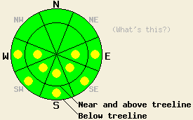
Very early this morning, avalanche danger is LOW for all elevations and aspects. Pockets of MODERATE danger will develop quickly today at all elevations on E-SE-S-SW-W aspects 35 degrees and steeper in response to daytime warming. |
|
|
|
High pressure remains in place over the forecast area. High level cloud cover that was over the region yesterday and last night has begun to clear out this morning. Air temperatures remained above freezing in nearly all locations overnight. An air temperature inversion is in place this morning allowing for below freezing air temperatures below about 6,500'. At higher elevations, air temperatures are in the mid to upper 30s this morning. Ridgetop winds shifted from southwest to south overnight and have become light. Continued light to moderate speed south to southwest winds are expected for today.
Observations made yesterday on Mt. Tallac (Desolation Wilderness area) indicated that a better than expected overnight refreeze had occurred Friday night above 7,800' and below 7,000'. The area between 7,000' and 7,800' had a much weaker overnight refreeze due to air temperature inversion and the warmest air having been trapped within that elevation range. The weaker refreeze was most evident in treed areas where radiational cooling was the most limited. Widespread melt freeze conditions existed in all areas below 9,000' that have received sun. Melt freeze conditions extended to higher elevations on E-SE-S-SW-W aspects. No evidence of instability was observed in this area during the morning hours and no additional reports of instability were received from the afternoon hours. In general, the snowpack is still in a transitional state above 8,500' on NW-N-NE-E aspects. Reasonably well developed corn snow conditions exist on E aspects below 8,500' and to near 10,000' on SE-S-SW-W aspects, especially in areas that did not receive significant wind loading during the last storm cycle.
Avalanche Concerns:
Avalanche concerns for today focus on warming instability. Overnight refreeze of the snow surface last night was dependent on radiational cooling as air temperatures were above freezing in most locations. High level cloud cover will have had a limiting effect on the amount of snow surface refreeze as compared to what can occur under clear skies. Rapidly warming air temperatures will not allow the snow surface to remain in a supportable state for long today. Even early this morning, the snow surface in heavily treed areas above 6,500' may not be supportable. As the day progresses, pockets of wet snow instability will form at all elevations on E-SE-S-SW-W aspects and possibly on mid to lower elevation NW-N-NE aspects as well. Timing will be everything today.
Very early this morning, avalanche danger is LOW for all elevations and aspects. Pockets of MODERATE danger will develop quickly today at all elevations on E-SE-S-SW-W aspects 35 degrees and steeper in response to daytime warming.
| 0600 temperature: | 30 to 38 deg. F. |
| Max. temperature in the last 24 hours: | 48 to 53 deg. F. |
| Average wind direction during the last 24 hours: | Southwest shifting to south |
| Average wind speed during the last 24 hours: | 17 mph |
| Maximum wind gust in the last 24 hours: | 30 mph |
| New snowfall in the last 24 hours: | O inches |
| Total snow depth: | 99 to 148 inches |
For 7000-8000 ft: |
|||
| Sunday: | Sunday Night: | Monday: | |
| Weather: | Mostly sunny skies. | Clear skies in the evening becoming partly cloudy. | Partly cloudy skies. |
| Temperatures: | 52 to 59 deg. F. | 31 to 36 deg. F. | 50 to 57 deg. F. |
| Wind direction: | S shifting to SW | SW | S |
| Wind speed: | Up to 10 mph. | Around 10 mph in the evening becoming light. | Around 10 mph in the morning. Winds increasing to 15 to 25 mph with gusts to 35 mph in the afternoon. |
| Expected snowfall: | O in. | O in. | O in. |
For 8000-9000 ft: |
|||
| Sunday: | Sunday Night: | Monday: | |
| Weather: | Mostly sunny skies. | Clear skies in the evening becoming partly cloudy. | Partly cloudy skies. |
| Temperatures: | 47 to 54 deg. F. | 32 to 37 deg. F. | 49 to 55 deg. F. |
| Wind direction: | S shifting to SW | SW | S |
| Wind speed: | 5 to 10 mph in the morning. Winds increasing to 10 to 15 mph with gusts to 25 mph in the afternoon. | 10 to 15 mph in the evening decreasing to 5 to 10 mph. | 10 to 20 mph with gusts to 30 mph. Winds increasing to 20 to 35 mph with gusts to 55 mph in the afternoon. |
| Expected snowfall: | O in. | O in. | O in. |


This website is owned and maintained by the non-profit arm of the Sierra Avalanche Center. Some of the content is updated by the USDA avalanche forecasters including the forecasts and some observational data. The USDA is not responsible for any advertising, fund-raising events/information, or sponsorship information, or other content not related to the forecasts and the data pertaining to the forecasts.

