In partnership with: 
|
April 20, 2010 at 6:56 am |
|
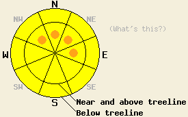
This morning, avalanche danger is MODERATE below 9,000' on all aspects on slopes 37 degrees and steeper due to wet snow instability. After the onset of precipitation, concerns will gradually shift to storm snow instability with avalanche danger remaining at MODERATE above and below treeline on all aspects on slopes 35 degrees and steeper. Pockets of CONSIDERABLE danger may form in wind loaded areas on NW-N-NE-E aspects 37 degrees and steeper this afternoon or tonight if the upper end of forecast snowfall amounts are reached. |
|
|
|
A storm system will move into the forecast area today. Cloud cover has steadily increased over the forecast area for the past 36 hours. Air temperatures below 9,000' across the forecast area this morning are at or above freezing. Ridgetop winds remain out of the southwest and increased to strong in speed overnight. Precipitation is expected to begin after 8 am this morning with snow level beginning between 7,000 and 8,000'. Snow level is expected to fall to below 5,000' either this afternoon or possibly not until tonight depending on the speed of the storm system moving through the area and the timing of subsequent cold front passage. New snow amounts of 3 to 11 inches are expected above 7,000' over the next 24 hours.
Yesterday, observations made on Mt. Judah (Donner Summit area) revealed that a weak to decent overnight refreeze of the top 1 to 4 inches of the snow surface had occurred Sunday night. Open areas held the deepest snow surface refreeze. Surface snow melted fast in sun exposed areas on E-SE-S aspects. By 9:30am, 3 inches of wet corn snow over a marginally skier supportable crust existed on E aspects in large open areas between 8,200' and 7,700'. Slightly more supportable conditions with 1 to 2 inches of wet corn snow over crust existed on S aspects at that time. W and N aspects remained very frozen at 10:00am, but softened during the afternoon hours.
Avalanche Concern #1: Wet snow instability
With above freezing air temperatures below 9,000' and thick cloud cover over the region, a poor to non existent snow surface refreeze is expected to have occurred last night. Wet snow instability due to free water that formed yesterday within the snowpack and did not refreeze overnight is expected to keep instability active this morning. Human triggered wet loose and wet slab avalanches will remain possible in steep terrain mainly on E-SE-S-SW-W aspects and possibly on low elevation NW-N-NE aspects today. After the onset of precipitation, areas that receive rain may see an increase in instability as more free water is added to the snowpack. In areas where snowfall occurs, refreezing of the snowpack will lead to crust formation at the old/new snow interface and eventually increase the strength of the snow at and below the old/new snow interface.
Avalanche Concern #2: Storm snow
New snowfall that occurs today will eventually shift concerns away from wet snow and focus them on storm snow instability. The greatest areas of instability are expected to form as wind slabs near and above treeline in wind loaded areas on NW-N-NE-E aspects. Below treeline, areas of instability are expected to form on all aspects, especially on open convex slopes if the upper end of new snowfall amounts are reached. New snow will fall on a variety of old snow surfaces today. In most areas new snow will accumulate on wet snow or crust surfaces with new snow falling on cold wind packed snow, not affected by melt freeze on northerly aspects above 9,500'. This will allow for a variance in the strength of bonding of new snow to the old snow surface that may have stark differences from one aspect to another or at different elevations on the same aspect.
This morning, avalanche danger is MODERATE below 9,000' on all aspects on slopes 37 degrees and steeper due to wet snow instability. After the onset of precipitation, concerns will gradually shift to storm snow instability with avalanche danger remaining at MODERATE above and below treeline on all aspects on slopes 35 degrees and steeper. Pockets of CONSIDERABLE danger may form in wind loaded areas on NW-N-NE-E aspects 37 degrees and steeper this afternoon or tonight if the upper end of forecast snowfall amounts are reached.
| 0600 temperature: | 32 to 35 deg. F. |
| Max. temperature in the last 24 hours: | 44 to 53 deg. F. |
| Average wind direction during the last 24 hours: | Southwest |
| Average wind speed during the last 24 hours: | 47 mph |
| Maximum wind gust in the last 24 hours: | 89 mph |
| New snowfall in the last 24 hours: | O inches |
| Total snow depth: | 95 to 144 inches |
For 7000-8000 ft: |
|||
| Tuesday: | Tuesday Night: | Wednesday: | |
| Weather: | Cloudy skies with rain and snow in the morning. Snow showers in the afternoon. | Cloudy skies with snow showers in the evening. Numerous snow showers after midnight. | Cloudy skies with snow showers. |
| Temperatures: | 28 to 35 deg. F. | 13 to 20 deg. F. | 21 to 28 deg. F. |
| Wind direction: | SW | SW shifting to W | W |
| Wind speed: | 15 to 25 mph with gusts to 55 mph. Winds decreasing to 10 to 15 mph with gusts to 35 mph in the afternoon. | 15 to 20 mph with gusts to 40 mph. Winds decreasing to around 10 mph after midnight. | 10 to 15 mph with gusts to 30 mph in the afternoon. |
| Expected snowfall: | 2 to 4 in. | 1 to 3 in. | 1 to 3 in. |
For 8000-9000 ft: |
|||
| Tuesday: | Tuesday Night: | Wednesday: | |
| Weather: | Cloudy skies with snow in the morning. Snow showers in the afternoon. | Cloudy skies with snow showers in the evening. Numerous snow showers after midnight. | Cloudy skies with snow showers. |
| Temperatures: | 25 to 32 deg. F. | 9 to 16 deg. F. | 17 to 24 deg. F. |
| Wind direction: | SW | SW shifting to W | NW |
| Wind speed: | 40 to 60 mph with gusts to 90 mph. Gusts decreasing to 65 mph in the afternoon. | 15 to 25 mph with gusts to 40 mph. Winds decreasing to 10 to 15 mph with gusts to 25 mph after midnight. | 10 to 15 mph with gusts to 25 mph. Winds increasing to 15 to 25 mph with gusts to 40 mph in the afternoon. |
| Expected snowfall: | 3 to 6 in. | 3 to 5 in. | 2 to 4 in. |


This website is owned and maintained by the non-profit arm of the Sierra Avalanche Center. Some of the content is updated by the USDA avalanche forecasters including the forecasts and some observational data. The USDA is not responsible for any advertising, fund-raising events/information, or sponsorship information, or other content not related to the forecasts and the data pertaining to the forecasts.

