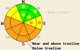
This Avalanche Advisory was published on April 23, 2010:

|
April 23, 2010 at 7:00 am |
|
The avalanche danger will rise to CONSIDERABLE today on the sun-exposed SE-S-SW-W aspects steeper than 35 degrees due to rapid daytime warming. Some pockets of CONSIDERABLE danger may also form on E aspects. On the NW-N-NE aspects areas of MODERATE avalanche danger still remain on wind-loaded slopes. |
|
|
|
Forecast Discussion:
Skies cleared overnight as the low-pressure system moved east of the region. A high-pressure ridge should replace this system and bring sunny, warm weather to the forecast area through tomorrow. The forecast calls for the winds to start to decrease today and shift to southwest and west over the next 24 hours. Today daytime highs should climb back into the low to mid 40's above 8000' and into the low to 50's above 7000'.
Human-triggered shooting cracks continued to occur near Crater Lake (near Carson Pass - snowpit) and on Tamarack Peak (Mt Rose backcountry - photos) on wind-loaded, N-NE-E facing aspects in near and above treeline terrain yesterday. Snowpit tests, informal hand pits, and weighting test slopes all indicated that weaknesses in the storm snow still exist in these areas. On Tamarack Peak a skier triggered a small avalanche similar to ones observed earlier this week. The slide occurred on an E facing, 37 degree, wind-loaded slope near treeline. The fracture propagated about 30 ft across the slope and the crown measured about 1-1.5 ft deep. Debris from this slide ran about 200-300 ft down slope (photos). Lingering storm snow weaknesses like density changes in the recent snow and the interface between the stiff wind slabs and the lighter snow below them served as the failure layer for most off the cracking and for the avalanche. In both these areas, the northeast winds increased more quickly than forecasted yesterday and started to transport significant amounts of snow from the E-NE-N aspects onto the NW-W-SW-S-SE aspects by midday.
Avalanche Concern #1: Rapid warming of new snow
Daytime highs well above freezing and 10-15 degrees warmer than yesterday combined with intense sunshine will cause the recent snow to warm up quickly today. This rapid warming will destabilize the recent snow making avalanche activity due to rapid warming the primary avalanche concern. Added to these factors the NE winds have moved a significant amount of new snow onto the slopes that will experience the most warming today: the W-SW-S-SE aspects. Human-triggered and natural point-release avalanches and some slab avalanches could occur today as the snowpack warms up. The sun-exposed W-SW-S-SE-E aspects will hold the best potential for these warming instabilities; however, pockets of warming instabilities could also exist on the low to mid elevation northerly aspects. These slides could be large enough to bury or injure a person.
Avalanche Concern #2: Wind slabs
The NE winds have wind loaded the W-SW-S aspects and cross-loaded the NW and SE aspects adding new fragile wind slabs to those aspects. Human triggered avalanches involving these new wind slabs will be possible today. Natural activity involving these new wind slabs will be possible as well on the sun-exposed aspects due to the rapid warming mentioned above. As the NE winds built these new wind slabs, they should have reduced the size of most of the wind slabs that formed during the recent storm, some pockets of stiff wind slabs may remain on the N-NE-E aspects near and above treeline. These older slabs should be more difficult to trigger today but the right trigger in the right spot could still break the bonds between these wind slabs and the lighter snow beneath them.
The bottom line:
The avalanche danger will rise to CONSIDERABLE today on the sun-exposed SE-S-SW-W aspects steeper than 35 degrees due to rapid daytime warming. Some pockets of CONSIDERABLE danger may also form on E aspects. On the NW-N-NE aspects areas of MODERATE avalanche danger still remain on wind-loaded slopes.
Weather Observations from along the Sierra Crest between 8200 ft and 8800 ft:
| 0600 temperature: | 25-29 deg. F. |
| Max. temperature in the last 24 hours: | 32 deg. F. |
| Average wind direction during the last 24 hours: | Northeast |
| Average wind speed during the last 24 hours: | 30 mph |
| Maximum wind gust in the last 24 hours: | 63 mph |
| New snowfall in the last 24 hours: | 0-2 inches |
| Total snow depth: | 96-147 inches |
Two-Day Mountain Weather Forecast - Produced in partnership with the Reno NWS
For 7000-8000 ft: |
|||
| Friday: | Friday Night: | Saturday: | |
| Weather: | Sunny | Clear | Sunny in the morning becoming partly cloudy in the afternoon |
| Temperatures: | 48-54 deg. F. | 30-36 deg. F. | 47-54 deg. F. |
| Wind direction: | Northeast | Southwest | West |
| Wind speed: | up to 10 mph | up to 10 mph | 10-15 mph with gusts to 25 mph |
| Expected snowfall: | O in. | O in. | O in. |
For 8000-9000 ft: |
|||
| Friday: | Friday Night: | Saturday: | |
| Weather: | Sunny with a few clouds developing over the ridges this afternoon | Clear | Sunny in the morning becoming partly cloudy in the afternoon |
| Temperatures: | 39-47 deg. F. | 26-33 deg. F. | 45-51 deg. F. |
| Wind direction: | Northeast | Southwest | East shifting to the west |
| Wind speed: | 10-20 with gusts to 30 mph | up to 10 mph | 10-15 mph increasing to 10 -20 mph with gusts to 35 mph |
| Expected snowfall: | O in. | O in. | O in. |


