In partnership with: 
|
November 20, 2010 at 7:43 am |
|
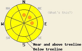
Near and above treeline, avalanche danger is MODERATE with pockets of CONSIDERABLE danger on N-NE-E aspects, 35 degrees and steeper. Below treeline, avalanche danger is MODERATE in open areas, 35 degrees and steeper. Rocks, down trees, and stumps will present a significant hazard to backcountry travelers today due to the overall shallow snow cover. An increase in avalanche danger is expected to occur tonight in response to high intensity snowfall. |
|
|
|
A break in snowfall intensity will occur during most of the day today before the next high intensity snowfall event effects the forecast area tonight. Remote sensors are reporting new snow amounts of 10 to 18 inches along the Sierra Crest and 6 to 14 inches along the Carson Range. Air temperatures at the 8,500' level are in the mid to upper teens with minimal warming expected during the day. Ridgetop winds remain out of the southwest this morning and are forecast to remain moderate to strong in speed today.
Observations made yesterday on Mt. Judah (Donner Summit area) continue the trend of east wind scoured avalanche start zones and a shallow stable snowpack existing in wind protected areas. This matches well with other observations made over the past few days on Tamarack Peak (Mount Rose area) and on Elephant's Back (Carson Pass area). Across the forecast area, the snowpack that existed prior to last night's new snow was 4 to 16 inches deep and consisted of a surface melt-freeze crust and a varying mix of rounds, lightly faceted crystals, and additional crusts below. No evidence of instability was observed within the old snow layers this past week. With the addition of new snow last night, the snowpack in most previously snow covered areas is now 10 to 34 inches deep.
Avalanche Concerns:
New snow associated with this storm has fallen on either bare ground or a stable snowpack. Avalanche concerns for today focus on storm snow. The combination of light snowfall and continued southwest winds will allow for slow but continued growth of slabs that formed last night in wind loaded areas. This will be most prevalent in N-NE-E aspects in near and above treeline areas and less widespread but still a concern in other wind affected areas both above and below treeline. In many areas that have received wind loading, the additional snow accumulation may be sufficient to fully bury and negate the ability of natural anchors to prevent snowpack failure within the storm snow.
Near and above treeline, avalanche danger is MODERATE with pockets of CONSIDERABLE danger on N-NE-E aspects, 35 degrees and steeper. Below treeline, avalanche danger is MODERATE in open areas, 35 degrees and steeper. Rocks, down trees, and stumps will present a significant hazard to backcountry travelers today due to the overall shallow snow cover. An increase in avalanche danger is expected to occur tonight in response to high intensity snowfall.
| 0600 temperature: | 17 to 19 deg. F. |
| Max. temperature in the last 24 hours: | 31 to 33 deg. F. |
| Average wind direction during the last 24 hours: | Southwest |
| Average wind speed during the last 24 hours: | 33 mph |
| Maximum wind gust in the last 24 hours: | 95 mph |
| New snowfall in the last 24 hours: | 6 to 18 inches |
| Total snow depth: | 6 to 34 inches |
For 7000-8000 ft: |
|||
| Saturday: | Saturday Night: | Sunday: | |
| Weather: | Cloudy skies with snow. | Cloudy skies with high intensity snowfall. | Cloudy skies with snow. |
| Temperatures: | 15 to 22 deg. F. | 7 to 14 deg. F. | 13 to 20 deg. F. |
| Wind direction: | SW | SW | SW |
| Wind speed: | 15 to 25 mph with gusts to 40 mph. | 20 to 30 mph with gusts to 50 mph. | 15 to 25 mph with gusts to 45 mph. |
| Expected snowfall: | 3 to 6 in. | 12 to 20 in. | 6 to 10 in. |
For 8000-9000 ft: |
|||
| Saturday: | Saturday Night: | Sunday: | |
| Weather: | Cloudy skies with snow. | Cloudy skies with high intensity snowfall. | Cloudy skies with snow. |
| Temperatures: | 11 to 18 deg. F. | 2 to 9 deg. F. | 12 to 18 deg. F. |
| Wind direction: | SW | SW | SW |
| Wind speed: | 30 to 45 mph with gusts to 65 mph. | 30 to 50 mph with gusts to 85 mph. | 25 to 40 mph with gusts to 60 mph. |
| Expected snowfall: | 4 to 7 in. | 12 to 20 in. | 6 to 10 in. |


This website is owned and maintained by the non-profit arm of the Sierra Avalanche Center. Some of the content is updated by the USDA avalanche forecasters including the forecasts and some observational data. The USDA is not responsible for any advertising, fund-raising events/information, or sponsorship information, or other content not related to the forecasts and the data pertaining to the forecasts.

