In partnership with: 
|
November 24, 2010 at 7:30 am |
|
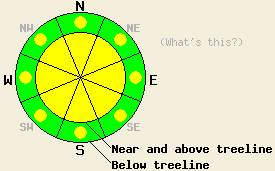
Near and above treeline on slopes steeper than 35 degrees, MODERATE avalanche danger exists on all aspects. Below treeline pockets of MODERATE avalanche danger exist on open slopes steeper than 35 degrees. Human-triggered avalanches are possible today. |
|
|
|
Yesterday's cold front left another 10-20 inches of new snow and mass of cold arctic air over the forecast area. This morning temperatures in the mountains are in the single digits, and many of the valleys hover below zero. Today, a high pressure ridge should begin building over the region bringing clear skies and light to moderate northeast and east winds. Temperatures should remain cold today with daytime highs only reaching into the upper teens in the mountains. By tomorrow temperatures should reach back into the 30's in the mountains as the high pressure ridge becomes more established. Expect the valleys to remain cold due to a strong inversion. The east winds should continue though tomorrow.
Intense snowfall and wind resulted in some avalanche activity yesterday morning. At least three relatively small natural avalanches occurred on the East face of Mt. Judah. Natural cornice failure most likely triggered these slides, and they most likely occurred around mid morning yesterday (photos and report). These slides measured about three ft. deep, up to 100 ft wide, and ran up to 300 ft. downslope. In the case of these avalanches, the wind slabs that formed during the intense snowfall and wind yesterday morning overloaded the bonds holding them to Monday's snow surface. By midday when the storm started to subside, the best window for natural avalanches had passed. The cornices and wind slabs that formed earlier in the day still remained sensitive to human-triggering. Cornices broke with one or two kicks several ft. away from their edges. On one ENE facing test slope, an oven-sized cornice block triggered a small slab avalanche when it hit the wind-loaded slope below (photos and report). Hand pits, pole probes, and test pits all showed that Tuesday morning's snow formed a slightly more dense layer on top of the the softer snow from Monday. These test also showed that this layer had started to bond to the layers below it by yesterday afternoon.
Avalanche Concerns:
Even though the wind slabs that formed yesterday have started to bond to the snow below them, the additional weight of a skier, boarder, snowmobiler, or snowshoe-er could still break these bonds today causing an avalanche. Avalanches involving these wind slabs could easily bury a person. The largest and most tender of these wind slabs will exist on the wind-loaded N-NE-E aspects and cross-loaded NW and SE aspects near and above treeline. Large, tender, newly formed cornices also reside above many of these slopes. These cornices should continue to break well away from their edges and could cause avalanches on the slopes below. As the winds shift to the NE and E today, they will start to move snow away from these wind slabs and cornices onto the SE-S-SW-W aspects. New, smaller wind slabs will start to form on these aspects near and above treeline. These new wind slabs could also be sensitive to human-triggering today. Some smaller, isolated wind slabs may still exist below treeline in open areas. Use clues like cornices, ripples, drifts, and blowing snow to determine where wind slabs exist today.
Note: Readings from the remote sensors do not seem as reliable as usual. Their data concerning snow depth and wind speed has not been matching observed conditions very well. The observations below are a mix of remote data and physical observations.
Near and above treeline on slopes steeper than 35 degrees, MODERATE avalanche danger exists on all aspects. Below treeline pockets of MODERATE avalanche danger exist on open slopes steeper than 35 degrees. Human-triggered avalanches are possible today.
| 0600 temperature: | 3 deg. F. |
| Max. temperature in the last 24 hours: | 21 deg. F. |
| Average wind direction during the last 24 hours: | Southwest shifting to North |
| Average wind speed during the last 24 hours: | 40 until last night then dropping to 5-15 mph |
| Maximum wind gust in the last 24 hours: | 60 mph |
| New snowfall in the last 24 hours: | 10-20 inches |
| Total snow depth: | 44-66 inches |
For 7000-8000 ft: |
|||
| Wednesday: | Wednesday Night: | Thursday: | |
| Weather: | Sunny | Clear | Sunny in the morning becoming partly cloudy in the afternoon. |
| Temperatures: | 15-22 deg. F. | 6-12 deg. F. | 29-36 deg. F. |
| Wind direction: | Northwest shifting to the Northeast | East | East |
| Wind speed: | up to 10 mph | 10 mph | 10 mph |
| Expected snowfall: | O in. | O in. | O in. |
For 8000-9000 ft: |
|||
| Wednesday: | Wednesday Night: | Thursday: | |
| Weather: | Sunny | Clear | Sunny in the morning becoming partly cloudy in the afternoon. |
| Temperatures: | 11-18 deg. F. | 5-11 deg. F. | 35-41 deg. F. |
| Wind direction: | Northwest shifting to the Northeast | East | East |
| Wind speed: | 15-25 mph with gusts to 45 mph | 15-25 mph with gusts to 50 mph | 15-25 mph with gusts to 50 mph |
| Expected snowfall: | O in. | O in. | O in. |


This website is owned and maintained by the non-profit arm of the Sierra Avalanche Center. Some of the content is updated by the USDA avalanche forecasters including the forecasts and some observational data. The USDA is not responsible for any advertising, fund-raising events/information, or sponsorship information, or other content not related to the forecasts and the data pertaining to the forecasts.

