In partnership with: 
|
November 25, 2010 at 6:36 am |
|
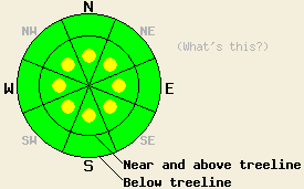
Isolated pockets of MODERATE avalanche danger remain on the most heavily wind-loaded N-NE-E-SE aspects and on newly wind-loaded NW-W-SW-S-SE aspects near and above treeline on slopes steeper than 35 degrees. Below treeline the avalanche danger is LOW. |
|
|
|
The high pressure ridge over the forecast area should bring warmer temperatures, mostly clear skies, and north to east winds to the mountains today. This ridge should begin moving eastward as a low pressure pushes toward the region. By tonight a few thin clouds should start to develop, and the winds should shift to the south and west ahead of this low. The clouds and southwest winds should increase tomorrow afternoon and evening as the low moves closer.
Calm, sunny, mild weather yesterday allowed the snowpack to continue settling. Evidence of a few recent avalanches remained on wind-loaded, N-NE-E aspects above treeline between Red Lake Peak and Stevens Peak. These slides most likely occurred naturally during the storm on Tuesday. One small, isolated wind slab did release in response to a skier's weight on Red Lake Peak during the day yesterday. This slide was about 25 ft wide and 1 ft deep (photos and more info). In most other areas on Red Lake Peak and on Tamarack Peak in the Mt. Rose area observations showed a mostly stable snowpack. Hand pits and layer bonding tests indicated that layers in the snowpack continue to form bonds within themselves and with other layers. On Tamarack Peak some minor cracking did occur on a small wind-loaded, E facing, 33 degree test slope near treeline. Ski cuts on other similar test slopes did not display any signs of instability. By late afternoon a noticeable sun crust had formed on southerly aspects up to 8500' in the Mt. Rose area and in the Carson Pass area.
Avalanche Concerns:
Some wind slabs that formed during Tuesday's storm could still fail in response to the added weight of a person. These fragile wind slabs have become more and more isolated as the snowpack continues to settle and bond. The best places for these isolated pockets of instability will be on the most wind-loaded N-NE-E aspects and cross-loaded SE aspects near and above treeline on slopes steeper than 35 degrees. Steep, wind-loaded, complex terrain such as hanging snowfields or couloirs may also hold some of these fragile wind slabs. Expect any cornices formed during the storm to remain sensitive to human-triggering. The east and northeast winds did increase yesterday evening. The forecast calls for them to continue today. They should have started to transport enough snow from the N-NE-E aspects onto the SE-S-SW-W aspects to form new, small wind slabs. These new wind slabs could also be sensitive to human-triggering today.
Isolated pockets of MODERATE avalanche danger remain on the most heavily wind-loaded N-NE-E-SE aspects and on newly wind-loaded NW-W-SW-S-SE aspects near and above treeline on slopes steeper than 35 degrees. Below treeline the avalanche danger is LOW.
| 0600 temperature: | 10 deg. F. |
| Max. temperature in the last 24 hours: | 15 deg. F. |
| Average wind direction during the last 24 hours: | Calm till yesterday evening becoming ENE overnight |
| Average wind speed during the last 24 hours: | Calm till yesterday evening increasing to 30-35 mph |
| Maximum wind gust in the last 24 hours: | 48 mph |
| New snowfall in the last 24 hours: | O inches |
| Total snow depth: | 44-54 inches |
For 7000-8000 ft: |
|||
| Thursday: | Thursday Night: | Friday: | |
| Weather: | Sunny this morning becoming partly cloudy this afternoon. | Partly cloudy | Partly cloudy |
| Temperatures: | 28-35 deg. F. | 14-20 deg. F. | 33-40 deg. F. |
| Wind direction: | East | Variable | Southwest |
| Wind speed: | 10 mph | Light | 10 mph |
| Expected snowfall: | O in. | O in. | O in. |
For 8000-9000 ft: |
|||
| Thursday: | Thursday Night: | Friday: | |
| Weather: | Sunny this morning becoming partly cloudy this afternoon. | Partly cloudy | Partly cloudy |
| Temperatures: | 33-39 deg. F. | 18-25 deg. F. | 32-39 deg. F. |
| Wind direction: | East | Southeast to Southwest | Southwest |
| Wind speed: | 15-25 mph with gusts to 45 mph | 15-20 mph with gusts to 40 mph decreasing to 10-15 mph with gusts to 30 mph after midnight | 15-25 mph with gusts to 40 mph |
| Expected snowfall: | O in. | O in. | O in. |


This website is owned and maintained by the non-profit arm of the Sierra Avalanche Center. Some of the content is updated by the USDA avalanche forecasters including the forecasts and some observational data. The USDA is not responsible for any advertising, fund-raising events/information, or sponsorship information, or other content not related to the forecasts and the data pertaining to the forecasts.

