In partnership with: 
|
November 28, 2010 at 7:48 am |
|
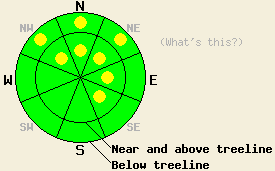
Near and above treeline, avalanche danger is LOW with pockets of MODERATE danger on NW-N-NE-E-SE aspects 35 degrees and steeper. Below treeline, avalanche danger is LOW with pockets of MODERATE danger on NW-N-NE aspects, 35 degrees and steeper. |
|
|
|
Yesterday's storm system is exiting the region today. Decreasing clouds with lingering isolated snow showers in the morning are expected for today. A continued decrease in cloud cover and sunny skies are forecast for tomorrow. New snow amounts for the past 24 hours generally range from 9 to 13 inches across the forecast area with one remote sensor in the Carson Pass area reporting 19 inches of new snow. Ridgetop winds have become light this morning, but are forecast to become moderate in speed out of the northwest as the morning progresses. Air temperatures at 8,500' are in the mid single digits to low teens this morning with around 5 degrees of daytime warming expected.
Observations made yesterday on Hidden Peak (West Shore Tahoe area) revealed shallow unstable slabs of storm snow had formed by noon in both wind loaded and wind protected areas along the summit ridge. This terrain is generally at treeline, N-NE-E aspects with an elevation of 9,000-9,200'. Within this area slab failure and shooting cracks on test slopes were widespread. These slabs consisted of a layer of lower density new snow at the base of the slab and higher density new snow above it which was created by warming air temperatures and rising snow levels during the morning hours (pit profile, photos).
A skier trigger avalanche occurred around 3pm on the southwest side of Caples Lake (Carson Pass area). The avalanche occurred in near treeline terrain at about 8,400' on a NE aspect 38 degree slope directly below a rock band. The avalanche measured 200' wide by 40' long and had a crown depth ranging from 6 to 12 inches. The avalanche was triggered from below on a lower angle (32 degree) slope which did not avalanche, but was overrun by debris. One skier was caught but was neither buried or injured (photo, more info). The slab failed at the old/new snow interface and was likely similar to the upside-down slabs observed yesterday in other areas.
Avalanche Concern #1: Lingering storm snow slabs
Instability of the upside-down surface slabs that formed yesterday is expected to linger into today. Evidence of instability such as shooting cracks and test slope failure should not be as widespread today, but pockets of instability are expected. This will most likely exist in areas that received recent wind loading where the difference in hardness between the surface slab and the lower density layer of snow below is more pronounced. NW-N-NE aspects are the most suspect with some expansion into E-SE aspects possible in more wind exposed terrain.
Avalanche Concern #2: Deep Slabs
In very isolated areas, the potential exists for deep slab instability occurring on the Nov 9 basal facet layer. Most of the recent snowpit data from around the forecast area has not shown the potential for deep slab instability. The Far East Ridge of Tamarack Peak (Mount Rose area) and Silver Peak (Pole Creek area) are the two locations where likely fracture propagation and possible deep slab instability on this layer have been noted. In both areas, the snowpack was tested on a N aspect in below treeline to near treeline terrain that is protected from east winds. Any deep slab avalanches that occur at this time will be very isolated. It will require the right trigger placed at exactly the right spot on exactly the right slope. If collapse of the Nov 9 layer is triggered, significant fracture propagation may occur, causing a large avalanche involving all of the storm snow from this past week. Due to the potential size of a deep slab avalanche this concern cannot be ignored, despite the fact that the snowpack conditions are appropriate for this avalanche type in very isolated areas only.
Near and above treeline, avalanche danger is LOW with pockets of MODERATE danger on NW-N-NE-E-SE aspects 35 degrees and steeper. Below treeline, avalanche danger is LOW with pockets of MODERATE danger on NW-N-NE aspects, 35 degrees and steeper.
| 0600 temperature: | 6 to 13 deg. F. |
| Max. temperature in the last 24 hours: | 22 to 27 deg. F. |
| Average wind direction during the last 24 hours: | Southwest |
| Average wind speed during the last 24 hours: | Prior to 10pm 35 mph, after 10 pm 7 mph |
| Maximum wind gust in the last 24 hours: | 64 mph |
| New snowfall in the last 24 hours: | 9 to 19 inches |
| Total snow depth: | 43 to 56 inches |
For 7000-8000 ft: |
|||
| Sunday: | Sunday Night: | Monday: | |
| Weather: | Mostly cloudy skies with isolated snow showers in the morning, becoming partly cloudy. | Partly cloudy skies. | Sunny skies. |
| Temperatures: | 15 to 22 deg. F. | 1 to 11 deg. F. | 23 to 30 deg. F. |
| Wind direction: | NW | NW shifting to NE after midnight. | E |
| Wind speed: | 10 to 15 mph with gusts to 30 mph. | 10 to 15 mph with gusts to 30 mph. | 10 to 15 mph with gusts to 30 mph. |
| Expected snowfall: | 0 to trace in. | O in. | O in. |
For 8000-9000 ft: |
|||
| Sunday: | Sunday Night: | Monday: | |
| Weather: | Mostly cloudy skies with isolated snow showers in the morning, becoming partly cloudy. | Partly cloudy skies. | Sunny skies. |
| Temperatures: | 14 to 20 deg. F. | 4 to 10 deg. F. | 22 to 29 deg. F. |
| Wind direction: | NW | NW shifting to NE after midnight. | NE |
| Wind speed: | 20 to 30 mph with gusts to 40 mph. | 20 to 30 mph decreasing to 15 to 25 mph after midnight. Gusts to 40 mph. | 20 to 30 with gusts to 40 mph. Winds decreasing to 10 to 15 mph with gusts to 30 mph in the afternoon. |
| Expected snowfall: | 0 to trace in. | O in. | O in. |


This website is owned and maintained by the non-profit arm of the Sierra Avalanche Center. Some of the content is updated by the USDA avalanche forecasters including the forecasts and some observational data. The USDA is not responsible for any advertising, fund-raising events/information, or sponsorship information, or other content not related to the forecasts and the data pertaining to the forecasts.

