In partnership with: 
|
December 4, 2010 at 7:50 am |
|
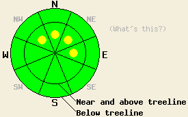
North of Hwy 88, avalanche danger near and above treeline is LOW with pockets of MODERATE danger lingering on recently wind loaded NW-N-NE-E aspects 35 degrees and steeper. Below treeline and all areas south of Hwy 88, avalanche danger is LOW. Please keep in mind that LOW danger means human trigger avalanches are unlikely, which is different than impossible, especially in highly complex or extreme terrain. |
|
|
|
Warm air with a small amount of moisture continues to move through the forecast area. Snow level has been fluctuating between about 6,200' and 7,000' for the past two days. The most recent significant snowfall which ended yesterday morning deposited anywhere from 2 to 13 inches of new snow above 7,000'. The greatest accumulations were observed in the Donner Summit area. Mostly cloudy to cloudy skies with scattered rain and snow showers are forecast for today. Air temperatures this morning at the 8,500' level are in the low to mid 30s with minimal daytime warming expected. Ridgetop winds shifted from southwest to south-southwest yesterday afternoon and have become light in speed this morning. Wind speeds are forecast to increase to moderate in speed as the day progresses.
Observations made yesterday on Mt. Judah (Donner Summit area) and on Lincoln Ridge (Yuba Pass area) revealed strikingly different degrees of snowpack instability. On Mt. Judah which received the highest snowfall amounts from this past snowfall event, significant wind loading created slabs up to 1 foot deep. Areas of natural cornice collapse triggered several avalanches in the area on steep above treeline NE-E aspects with snowpack failure occurring near the base of the storm snow. Fracture propagation tests in the snowpit easily identified this weak layer (videos, more info). On Lincoln Ridge where significant wind loading created slabs up to 8 inches deep revealed similar weak and easily collapsible cornices but with no snowpack failure on the slopes below. Snowpit data obtained in this area revealed no additional evidence of instability despite the recent snowfall and slab formation (pit profile, more info).
Avalanche Concern #1: Recent storm snow
Pockets of storm snow instability are expected to linger today in recently wind loaded areas. This will mainly occur near and above treeline on steep NW-N-NE-E aspects. Other areas with highly complex or extreme terrain such as near cliffs, rock bands, and within couloirs remain suspect as well. With wide variances in snowpack stability observed yesterday, today is a day for careful slope by slope stability analysis.
Avalanche Concern #2: Deep Slabs
Avalanches resulting from the failure of the Nov 9th facet layer near the bottom of the snowpack are a possibility in very isolated areas. Recent field observations indicating instability on this persistent weak layer have been limited to the Mount Rose area (map of study site 1, map of study site 2). Human triggering of this avalanche type will be difficult and require passing over the exact right spot on a slope where this layer exists. It is very likely that if a deep slab avalanche occurs, it will not be triggered by the first person to travel on the slope, and in fact the slope may be covered with tracks prior to the avalanche event. Any avalanches resulting from failures of this layer will be large and involve all of the snow accumulated since November 9th. This layer exists in isolated areas near and below treeline on N-NE aspects that are sheltered from the east winds. Near and above treeline terrain on N-NE aspects with east wind exposure had this layer removed by previous wind events. On other aspects it was destroyed by the sun or did not become sufficiently faceted to present an instability problem.
North of Hwy 88, avalanche danger near and above treeline is LOW with pockets of MODERATE danger lingering on recently wind loaded NW-N-NE-E aspects 35 degrees and steeper. Below treeline and all areas south of Hwy 88, avalanche danger is LOW. Please keep in mind that LOW danger means human trigger avalanches are unlikely, which is different than impossible, especially in highly complex or extreme terrain.
| 0600 temperature: | 30 to 34 deg. F. |
| Max. temperature in the last 24 hours: | 32 to 43 deg. F. |
| Average wind direction during the last 24 hours: | South-Southwest |
| Average wind speed during the last 24 hours: | 30 mph |
| Maximum wind gust in the last 24 hours: | 69 mph |
| New snowfall in the last 24 hours: | 0 to 2 inches |
| Total snow depth: | 30 to 54 inches |
For 7000-8000 ft: |
|||
| Saturday: | Saturday Night: | Sunday: | |
| Weather: | Mostly cloudy to cloudy skies with scattered rain and snow showers. | Cloudy skies with a chance of snow showers in the evening. Snow showers likely after midnight. | Cloudy skies with snow showers likely in the morning. A chance of rain and snow showers in the afternoon. |
| Temperatures: | 32 to 37 deg. F. | 29 to 33 deg. F. | 32 to 38 deg. F. |
| Wind direction: | S | Variable | S |
| Wind speed: | Up to 10 mph. | Light winds | 10 to 15 mph with gusts to 25 mph. |
| Expected snowfall: | 0 to trace in. | Up to 1 in. | Up to 1 in. |
For 8000-9000 ft: |
|||
| Saturday: | Saturday Night: | Sunday: | |
| Weather: | Mostly cloudy to cloudy skies with scattered snow showers. | Cloudy skies with a chance of snow showers in the evening. Snow showers likely after midnight. | Cloudy skies with snow showers likely in the morning. A chance of snow showers in the afternoon. |
| Temperatures: | 27 to 34 deg. F. | 23 to 30 deg. F. | 29 to 35 deg. F. |
| Wind direction: | S | S | SW |
| Wind speed: | 15 to 25 mph with gusts to 50 mph. | 15 to 25 mph with gusts to 50 mph. | 20 to 30 mph with gusts to 45 mph. Gusts increasing to 60 mph in the afternoon. |
| Expected snowfall: | Up to 1 in. | Up to 1 in. | Up to 1 in. |


This website is owned and maintained by the non-profit arm of the Sierra Avalanche Center. Some of the content is updated by the USDA avalanche forecasters including the forecasts and some observational data. The USDA is not responsible for any advertising, fund-raising events/information, or sponsorship information, or other content not related to the forecasts and the data pertaining to the forecasts.

