In partnership with: 
|
December 7, 2010 at 7:55 am |
|
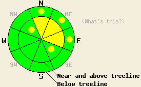
Near and above treeline MODERATE avalanche danger exists on N-NE-E aspects 35 degrees and steeper with pockets of MODERATE danger on NW and SE aspects. Below treeline the avalanche danger is mostly LOW with pockets of MODERATE danger on wind-loaded N-NE-E slopes steeper than 35 degrees. |
|
|
|
Another 0-3 inches of snow fell early yesterday morning as the storm dissipated. The small high pressure ridge that replaced the storm yesterday afternoon has lingered a little longer than expected. This ridge should keep skies mostly clear today and bring warmer temperatures and mild winds to the forecast area. Another low pressure system should begin to affect the region tonight. Expect an increase in clouds and southwest winds overnight and tomorrow. This storm should also bring some more snow starting early tomorrow morning. Snow levels should remain high (about 7000 ft.) for this storm.
A group of snowboarders triggered several soft slabs on Jake's Peak (West Shore area) yesterday morning. These slabs seem to have failed near the base of the new snow and entrained most of the new snow. They all measured between 6 and 12 inches deep and 50-75 ft. wide. Snowpit data from later in the day on Jake's (video and photos) and Hidden Peak (also on the West Shore) showed a firm, dense wind slab sitting on top of much softer new snow. Layer bonding tests indicated that the bonds between these layers remained fragile and that once a fracture started it could travel along this interface. Observations from the Mt. Judah (video and photos) area showed a similar upside-down snowpack (hard, dense wind slab on top of lighter snow) with similar weakness. One natural avalanche visible from the top of Hidden Peak occurred above Cliff Lake in the Desolation Wilderness (more info), and some small natural avalanches resulting from what appeared to be natural cornice failure occurred on Wildflower Ridge (near Judah). In lower elevation areas (below 7800 ft.) on the West Shore, much less new snow accumulated. It sat on top of a rain crust and wet snow. Snowpit data and hand pits in these lower elevation areas indicated that the new snow was forming good bonds with crusts and wet snow (pit profile).
Avalanche Concern #1: Wind Slabs
The firm, dense wind slabs sitting on top of soft, light snow will remain fragile today. Warmer temperatures and no new loading overnight should have allowed the bonds between these layers to strengthen some making natural avalanches resulting from these wind slabs unlikely. However, the additional weight of a person (skier, rider, snowmobiler) on top of the wind slabs should still be enough to break the bonds holding them in place. Human-triggered avalanches involving these wind slabs will remain possible today. The most fragile and largest of these wind slabs will exist on wind-loaded N-NE-E aspects and cross-loaded SE and NW aspects near and above treeline. The strong winds that formed these slabs also pushed them farther into traditionally sheltered areas (like trees, farther down slope than usual, or on open below treeline slopes). Use clues like cornices, blowing snow, ripples, drifts, and other wind created textures to tell where these wind slabs exist.
Avalanche Concern #2: Deep Slabs
Observations show the Nov 9th facet layer (weak, sugary snow) near the bottom of the snowpack slowly gaining strength. Areas where avalanches resulting from the failure of this layer remain possible are growing more and more isolated and more and more disconnected. These types of avalanches should be very difficult to trigger unless a person finds the exact right spot on a slope where this layer exists. These kind of avalanches can be triggered even on a slope that has seen several people descend it safely. Observations suggest that this layer only remains weak where a shallower snowpack exists on near and below treeline N-NE aspects that are sheltered from the east winds and had snow on them in early November. Observers have only found this persistent weak layer in the the Mt. Rose area so far.
Near and above treeline MODERATE avalanche danger exists on N-NE-E aspects 35 degrees and steeper with pockets of MODERATE danger on NW and SE aspects. Below treeline the avalanche danger is mostly LOW with pockets of MODERATE danger on wind-loaded N-NE-E slopes steeper than 35 degrees.
| 0600 temperature: | 31-33 deg. F. |
| Max. temperature in the last 24 hours: | 31-33 deg. F. |
| Average wind direction during the last 24 hours: | Southwest shifting to the south last night |
| Average wind speed during the last 24 hours: | 40-50 mph decreasing overnight to 20 mph |
| Maximum wind gust in the last 24 hours: | 111 mph |
| New snowfall in the last 24 hours: | 0-3 inches |
| Total snow depth: | 40-56 inches |
For 7000-8000 ft: |
|||
| Tuesday: | Tuesday Night: | Wednesday: | |
| Weather: | Mostly sunny | Mostly cloudy | Chance of snow in the morning with snow and rain becoming likely as the day progresses. Snow level around 7000 ft. |
| Temperatures: | 40-45 deg. F. | 29-37 deg. F. | 35-42 deg. F. |
| Wind direction: | South | Southwest | Southwest |
| Wind speed: | around 10 mph | 10-20 mph with gusts to 30 mph | 20-30 mph with gusts to 40 mph increasing to gusts to 55 mph in the afternoon |
| Expected snowfall: | O in. | O in. | up to 2 in. |
For 8000-9000 ft: |
|||
| Tuesday: | Tuesday Night: | Wednesday: | |
| Weather: | Mostly sunny | Mostly cloudy | Chance of snow in the morning with snow becoming likely as the day progresses. |
| Temperatures: | 39-45 deg. F. | 29-37 deg. F. | 34-40 deg. F. |
| Wind direction: | South | Southwest | Southwest |
| Wind speed: | 15-25 mph with gusts to 35 mph | 25-40 mph with gusts to 60 mph | 25-40 mph with gusts to 60 mph increasing to 35-50 mph with gusts to 85 mph in the afternoon |
| Expected snowfall: | O in. | O in. | up to 3 in. |


This website is owned and maintained by the non-profit arm of the Sierra Avalanche Center. Some of the content is updated by the USDA avalanche forecasters including the forecasts and some observational data. The USDA is not responsible for any advertising, fund-raising events/information, or sponsorship information, or other content not related to the forecasts and the data pertaining to the forecasts.

