In partnership with: 
|
December 8, 2010 at 7:59 am |
|
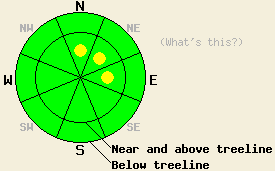
Near and above treeline, avalanche danger is LOW with the possible formation of isolated pockets of MODERATE danger above 7,500' after the onset of snowfall on N-NE-E aspects 37 degrees and steeper. For all other areas, avalanche danger is LOW. |
|
|
|
Another warm storm system is beginning to impact the forecast area. Southwest ridgetop winds increased overnight and will remain strong in speed through this evening. Air temperatures at 8,500' are at or above freezing. Snow level is forecast to remain at or above 7,500' for the next few days. This will be more of a wind event than a precipitation event with new snow amounts of up to 2 inches expected today above 7,500'.
Observations made yesterday on Elephant's Back (Carson Pass area) revealed some lingering instabilities within the recent storm snow. These weak layers proved difficult to trigger with signs of instability limited to snowpit data obtained above treeline on a NE aspect at 9,175' (pit profile, more info, photos). Observations made in the Mount Rose area on Relay Peak below treeline on a NE aspect at 9,360' yielded no evidence of instability within the recent storm snow, but did yield some ongoing evidence of possible fracture propagation potential on the Nov 9 basal facet layer (pit profile, more info). Between Relay Peak and Rose Knob peak in near treeline terrain on a N aspect at 9,440', no evidence of snowpack instability was observed (pit profile). Generally very hard snow surface conditions were observed in windward areas with very little to no snow available for wind transport from increasing SW winds.
Avalanche Concern #1: Storm snow
After to onset of precipitation, the combination of strong winds and high density new snow may produce isolated small slabs in the most heavily wind loaded areas above 7,500'. This will occur mainly near and above treeline on N-NE-E aspects. Areas of light rain on snow are not expected to cause significant instability today due to recent warming with air temperatures in the 40s yesterday for areas below 7,500'.
Avalanche Concern #2: Deep Slabs
Human triggered deep slab avalanche activity involving the Nov 9 basal facet layer falls in the unlikely but not impossible category. Evidence for this instability concern is limited to the Mount Rose area on near and below treeline N-NE aspects that are east wind protected. The Nov 9 layer continues to show evidence of rounding, but not to the point that it no longer is likely to allow fracture propagation to occur once snowpack failure is triggered. Due to the uneven coverage and patchy, disconnected distribution of this layer, areas where failure could occur on a slope scale are very isolated at best. With continued strength gains in the snow that makes up the overlying slab, areas where rocks and logs stick up through the weak layer and into the overlying slab are anchoring and further contributing to slope stability despite the presence of this weak basal facet layer.
Near and above treeline, avalanche danger is LOW with the possible formation of isolated pockets of MODERATE danger above 7,500' after the onset of snowfall on N-NE-E aspects 37 degrees and steeper. For all other areas, avalanche danger is LOW.
| 0600 temperature: | 32 to 37 deg. F. |
| Max. temperature in the last 24 hours: | 38 to 44 deg. F. |
| Average wind direction during the last 24 hours: | Southwest |
| Average wind speed during the last 24 hours: | Prior to 6pm 25 mph, after 6pm 52 mph |
| Maximum wind gust in the last 24 hours: | 97 mph |
| New snowfall in the last 24 hours: | O inches |
| Total snow depth: | 40 to 54 inches |
For 7000-8000 ft: |
|||
| Wednesday: | Wednesday Night: | Thursday: | |
| Weather: | Mostly cloudy to cloudy skies with a chance of snow in the morning. Rain and snow in the afternoon. | Cloudy skies with rain and snow likely. | Cloudy skies with a chance of rain and snow. |
| Temperatures: | 32 to 38 deg. F. | 26 to 33 deg. F. | 33 to 40 deg. F. |
| Wind direction: | SW | SW | SW |
| Wind speed: | 20 to 30 mph with gusts to 50 mph. Gusts increasing to 65 mph in the afternoon. | 20 to 30 mph with gusts to 65 mph. Gusts decreasing to 45 mph after midnight. | 15 to 25 mph with gusts to 35 mph |
| Expected snowfall: | Up to 2 in. | Up to 2 in. | 0 to trace in. |
For 8000-9000 ft: |
|||
| Wednesday: | Wednesday Night: | Thursday: | |
| Weather: | Mostly cloudy to cloudy skies with a chance of snow in the morning. Snow in the afternoon. | Cloudy skies with snow likely. | Cloudy skies with a chance of snow. |
| Temperatures: | 30 to 37 deg. F. | 23 to 30 deg. F. | 30 to 36 deg. F. |
| Wind direction: | SW | SW | SW |
| Wind speed: | 30 to 45 mph increasing to 35 to 55 mph in the afternoon. Gusts to 95 mph. | 30 to 50 mph with gusts to 95 mph. Gusts decreasing to 70 mph after midnight. | 25 to 35 mph with gusts to 60 mph. |
| Expected snowfall: | Up to 2 in. | Up to 2 in. | 0 to trace in. |


This website is owned and maintained by the non-profit arm of the Sierra Avalanche Center. Some of the content is updated by the USDA avalanche forecasters including the forecasts and some observational data. The USDA is not responsible for any advertising, fund-raising events/information, or sponsorship information, or other content not related to the forecasts and the data pertaining to the forecasts.

