In partnership with: 
|
December 13, 2010 at 7:49 am |
|
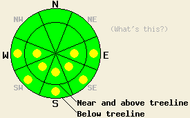
LOW avalanche danger exists in most areas this morning. Pockets of MODERATE avalanche danger will quickly develop on sun-exposed E-SE-S-SW-W aspects steeper than 37 degrees at all elevations due to daytime warming. |
|
|
|
The high pressure over the region should begin migrating east as a fast-moving low pressure pushes towards the area. Cloud cover and southwest winds should start increasing today and continue through tomorrow with wind speeds forecasted to reach into the 60's and 70's with gusts over 100 mph by tomorrow. Some precipitation may start to fall as early as tonight. Most of the precipitation should fall during the day tomorrow and into tomorrow evening. The forecast calls for snow levels to start at 7500 ft and drop to below 6000ft by tomorrow night. 4-8 inches of snow may fall during the day tomorrow in the mountains (more info).
A hard, icy, refrozen rain crust existed on the northerly aspects up to 9000 ft in the Castle Peak area yesterday. This crust varied from 3-8 inches in thickness (photo) and did not soften at all during the day yesterday. Observations since late last week show that this rain crust should exist across the forecast area up to at least 9500 ft. In the higher elevation areas or areas that received less precipitation (like Mt. Rose or other areas east of the lake) expect a thinner rain crust. In the mid to lower elevations along the Sierra Crest, expect a thicker rain crust. Snowpit data and layer bonding tests on a NW aspect at 8400 ft. on Castle Peak yesterday (pit profile) showed that this strong crust has bonded well to the consolidated snow below it. On southerly, sun-exposed aspects in the Castle Peak area yesterday, a thick layer of melt-freeze snow existed on the snow surface up to 9000 ft. By noon the top 2-3 inches of this melt-freeze snow had softened providing spring-like riding conditions. Below 7800 ft in this area 4-8 inches of wet, sticky snow existed in the sun-exposed areas by 12:30 pm. Observations showed similar conditions in the Mt. Rose area on Saturday.
Primary Avalanche Concern: Wet-Snow Instabilities
Even though air temperatures have stayed above freezing for the last 48 hours, a weak refreeze should have occurred last night due to the snow radiating heat out into the clear night sky. As the day warms back up, the sun should quickly melt this layer of frozen surface snow on the southerly, sun-exposed aspects. Some melting may even occur on the lower elevation northerly aspects as the cloud cover increases today. This melting will weaken the surface snow and form a layer of wet, unconsolidated snow on the surface in many areas. Human-triggered, wet-snow instabilities will remain possible today due to daytime warming. Roller balls, point releases, and sluffs should comprise the majority of these wet-snow instabilities. Even though most of these slow-moving, wet, loose snow avalanches may not be enough to bury a person, they could push a person into an area with serious consequences like over a cliff, into a creek or gully, or into some other terrain trap. These wet-snow instabilities could exist on any slope steeper than 37 degrees with a significant layer of wet, surface snow.
LOW avalanche danger exists in most areas this morning. Pockets of MODERATE avalanche danger will quickly develop on sun-exposed E-SE-S-SW-W aspects steeper than 37 degrees at all elevations due to daytime warming.
| 0600 temperature: | 38-43 deg. F. |
| Max. temperature in the last 24 hours: | 46-54 deg. F. |
| Average wind direction during the last 24 hours: | Southwest |
| Average wind speed during the last 24 hours: | 25-35 mph |
| Maximum wind gust in the last 24 hours: | 47 mph |
| New snowfall in the last 24 hours: | O inches |
| Total snow depth: | 32-48 inches |
For 7000-8000 ft: |
|||
| Monday: | Monday Night: | Tuesday: | |
| Weather: | Partly cloudy becoming mostly cloudy this afternoon. | Mostly cloudy with a slight chance of rain or snow after midnight. Snow level 7000-7500 ft. | Chance of rain or snow in the morning. Snow and rain becoming widespread by the afternoon. Snow levels starting at 7500 ft and dropping to 6000 ft by the evening. |
| Temperatures: | 42-52 deg. F. | 30-40 deg. F. | 28-38 deg. F. |
| Wind direction: | Southwest | Southwest | Southwest |
| Wind speed: | 10-20 mph with gusts to 40 mph | 10-15 mph with gusts to 30 mph increasing to 20-30 mph with gusts to 50 mph after midnight | 20-35 mph with gusts to 65 mph |
| Expected snowfall: | O in. | trace in. | 2-5 in. |
For 8000-9000 ft: |
|||
| Monday: | Monday Night: | Tuesday: | |
| Weather: | Partly cloudy becoming mostly cloudy this afternoon. | Mostly cloudy with a slight chance of snow after midnight. | Chance of snow in the morning. Snow becoming widespread by the afternoon. |
| Temperatures: | 38-48 deg. F. | 22-29 deg. F. | 27-32 deg. F. |
| Wind direction: | Southwest | Southwest | Southwest |
| Wind speed: | 25-35 mph with gusts to 55 mph | 40-55 mph with gusts to 90 mph | 50-70 mph with gusts to 110 mph |
| Expected snowfall: | O in. | trace in. | 4-8 in. |


This website is owned and maintained by the non-profit arm of the Sierra Avalanche Center. Some of the content is updated by the USDA avalanche forecasters including the forecasts and some observational data. The USDA is not responsible for any advertising, fund-raising events/information, or sponsorship information, or other content not related to the forecasts and the data pertaining to the forecasts.

