In partnership with: 
|
December 15, 2010 at 7:58 am |
|
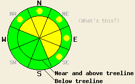
Near and above treeline, avalanche danger is MODERATE on NW-N-NE-E-SE aspects, 35 degrees and steeper. Below treeline, avalanche danger is LOW with isolated pockets of MODERATE danger in open areas on NW-N-NE-E-SE aspects, 37 degrees and steeper. |
|
|
|
The storm system that impacted the forecast area yesterday is exiting the region. Snowfall and strong winds ended last night between 10pm and midnight across the forecast area. Storm totals above 6,800' are running 12 to 21 inches with no real pattern discerning the areas with the highest accumulations. Southwest ridgetop winds have decreased to light in speed with remote sensors indicating that they are no longer strong enough to move snow. Occasional gusts strong enough to move snow are expected to occur today, but for the most part winds will remain light. Air temperatures at 8,500' are in the teens this morning with only a few degrees of warming expected during the day. A continual decrease in cloud cover is expected to occur today and into tonight.
Observations were made yesterday in the Mount Rose, Donner Summit, and Carson Pass areas. Snowpack instability and small intentionally human triggered avalanches were observed in the Mount Rose area (videos, photos, more info) while more stable conditions with minimal evidence of instability were observed near Carson Pass (pit profiles, more info) and in multiple locations in the Donner Summit area (pit profiles, more info). In all of these areas, good bonding of new snow to the rain crust at the old snow surface was observed. All snowpack failures were observed to occur within the storm snow. Any evidence of instability seemed limited to wind loaded areas. Evidence for fracture propagation was minimal with shooting cracks limited to 20' in the Mount Rose area and only to 3' on the south side of Carson Pass. No cracking over 1' long was observed on Andesite Ridge and Castle Peak in the Donner Summit area.
During the late afternoon and early nighttime hours snowfall rates of 1 to 2 inches per hour occurred in most areas with over half of the storm snow totals accumulating during this time. This was a period of cooling air temperatures allowing for lower density snow to deposit on top of higher density snow, which generally aids in snowpack stability. However, continued strong winds are expected to have caused significant wind loading and contributed to ongoing slab development. Any evidence of natural avalanche activity that is visible in the backcountry today likely occurred during this recent time period.
Primary Avalanche Concern: Storm snow
Avalanche concerns for today focus on lingering instabilities within the storm snow. The window for natural avalanche activity has past, but human triggered avalanches remain possible today. Easy to find evidence of snowpack instability will not be widespread today. Careful slope evaluation will be necessary to make a well informed travel decision as the expected pattern for avalanche activity today is expected as fairly isolated but potentially large. Look for signs of instability at or above the old/new snow interface, paying particular attention to any buried graupel layers. Recently wind loaded and cross loaded NW-N-NE-E-SE aspects, especially below cornice features and in more complex terrain with exposed rocks and cliff bands remain suspect. Some of these slopes may be difficult to evaluate accurately due to the expected isolated nature of today's snowpack instability.
Near and above treeline, avalanche danger is MODERATE on NW-N-NE-E-SE aspects, 35 degrees and steeper. Below treeline, avalanche danger is LOW with isolated pockets of MODERATE danger in open areas on NW-N-NE-E-SE aspects, 37 degrees and steeper.
| 0600 temperature: | 12 to 18 deg. F. |
| Max. temperature in the last 24 hours: | 32 to 34 deg. F. |
| Average wind direction during the last 24 hours: | Southwest |
| Average wind speed during the last 24 hours: | Prior to 8 pm 52 mph, after 8 pm 21 mph |
| Maximum wind gust in the last 24 hours: | 107 mph |
| New snowfall in the last 24 hours: | 12 to 21 inches |
| Total snow depth: | 40 to 67 inches |
For 7000-8000 ft: |
|||
| Wednesday: | Wednesday Night: | Thursday: | |
| Weather: | Mostly cloudy skies in the morning, becoming partly cloudy. A slight chance of snow. | Partly cloudy skies. | Partly cloudy skies. |
| Temperatures: | 23 to 28 deg. F. | 10 to 20 deg. F. | 28 to 33 deg. F. |
| Wind direction: | SW | W | SE |
| Wind speed: | 10 to 15 mph | Around 10 mph in the evening, becoming light. | 10 to 15 mph with gusts to 25 mph in the morning. |
| Expected snowfall: | 0 to trace in. | O in. | O in. |
For 8000-9000 ft: |
|||
| Wednesday: | Wednesday Night: | Thursday: | |
| Weather: | Partly cloudy skies. | Partly cloudy skies. | Partly cloudy skies. |
| Temperatures: | 15 to 22 deg. F. | 10 to 17 deg. F. | 21 to 28 deg. F. |
| Wind direction: | SW | SW shifting to E after midnight. | SE |
| Wind speed: | 15 to 25 mph with gusts to 35 mph. | 15 to 20 mph with gusts to 30 mph. | 15 to 20 mph with gusts to 35 mph. |
| Expected snowfall: | 0 to trace in. | O in. | O in. |


This website is owned and maintained by the non-profit arm of the Sierra Avalanche Center. Some of the content is updated by the USDA avalanche forecasters including the forecasts and some observational data. The USDA is not responsible for any advertising, fund-raising events/information, or sponsorship information, or other content not related to the forecasts and the data pertaining to the forecasts.

