In partnership with: 
|
December 23, 2010 at 7:59 am |
|
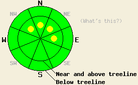
Near and above treeline, pockets of MODERATE avalanche danger linger on NW-N-NE-E aspects, 37 degrees and steeper. Below treeline, the avalanche danger is LOW in most areas. |
|
|
|
Another 1-2 inches of snow fell across the forecast area during the day yesterday. By mid afternoon the showers started to taper off. A high pressure ridge should let warmer temperatures and drier weather to prevail over the forecast area through tomorrow. This ridge has started to slowly progress eastward allowing a low pressure in the Pacific to begin pushing some high clouds into the region today. The forecast calls for more widespread clouds by tomorrow. This low will also cause the southwest winds to increase during the next 24 hours.
New, soft wind slabs did form on NW-N-NE aspects in the Castle Peak area (Donner Summit area) yesterday due to the increased winds and light snow. Most of these new wind slabs remained relatively small with the largest of them measuring about 1 ft in thickness. Some skier triggered cracks up to 3 ft long did occur on steep wind-loaded test slopes on Castle Peak and on Andesite Ridge (photo). Layer bonding tests and snowpit data indicated that the new wind slabs had not fully bonded to the snow below them (pit profile). Newly formed cornices remained tender during the day yesterday and broke easily in response to a person's weight. The oven-sized chunks of cornice did not trigger avalanches on the slopes below when they landed. Tests on the deeper layers in the snowpack in this area showed continued stabilization in the snowpack.
Primary avalanche concern: Wind Slabs
Pockets of instability due to the recently formed wind slabs will allow human triggered avalanches to remain possible today. These fragile wind slabs will most likely remain in near and above treeline areas on the most heavily wind-loaded slopes and in complex or extreme terrain (unsupported slopes, couloirs, cliffy areas, etc). As the winds increase again today, some additional wind-loading may occur adding a little more snow to these wind slabs. Avalanches due to failure of these wind slabs should remain within the top 12-18 inches of the snowpack; however, failures that step down into the older storm snow are not impossible especially in complex and extreme terrain. Cornices that exist above wind-loaded slopes will also remain sensitive to human triggering today.
Near and above treeline, pockets of MODERATE avalanche danger linger on NW-N-NE-E aspects, 37 degrees and steeper. Below treeline, the avalanche danger is LOW in most areas.
| 0600 temperature: | 24 deg. F. |
| Max. temperature in the last 24 hours: | 31 deg. F. |
| Average wind direction during the last 24 hours: | Southwest |
| Average wind speed during the last 24 hours: | 15-25 mph |
| Maximum wind gust in the last 24 hours: | 44 mph |
| New snowfall in the last 24 hours: | 1-2 inches |
| Total snow depth: | 64-94 inches |
For 7000-8000 ft: |
|||
| Thursday: | Thursday Night: | Friday: | |
| Weather: | High clouds thickening this morning and becoming cloudy. | Mostly cloudy | Considerable high clouds |
| Temperatures: | 34-39 deg. F. | 25-30 deg. F. | 38-43 deg. F. |
| Wind direction: | Southwest | South | South |
| Wind speed: | 5-15 mph | 10-20 mph | 10-20 mph with gusts to 45 mph in the afternoon |
| Expected snowfall: | O in. | O in. | O in. |
For 8000-9000 ft: |
|||
| Thursday: | Thursday Night: | Friday: | |
| Weather: | High clouds thickening this morning and becoming cloudy. | Mostly cloudy | Considerable high clouds |
| Temperatures: | 31-36 deg. F. | 27-33 deg. F. | 34-38 deg. F. |
| Wind direction: | Southwest | Southwest | Southwest |
| Wind speed: | 15-25 mph with gusts to 40 mph | 20-35 mph with gusts to 50 mph increasing to 60 mph after midnight | 25-35 mph with gusts to 65 mph |
| Expected snowfall: | O in. | O in. | O in. |


This website is owned and maintained by the non-profit arm of the Sierra Avalanche Center. Some of the content is updated by the USDA avalanche forecasters including the forecasts and some observational data. The USDA is not responsible for any advertising, fund-raising events/information, or sponsorship information, or other content not related to the forecasts and the data pertaining to the forecasts.

