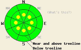
This Avalanche Advisory was published on December 31, 2010:

|
December 31, 2010 at 8:01 am |
|
Near and above treeline, pockets of MODERATE avalanche danger exist on all aspects on slopes steeper than 37 degrees. Below treeline, LOW avalanche danger exists. LOW danger does not mean no danger. Unstable snow can still exist on isolated terrain features. |
|
|
|
Forecast Discussion:
The high pressure ridge affecting the region will allow the cold northerly winds to continue today. The winds should start to decrease some today especially at the lower elevations. Temperatures will also remain well below normal. Tonight, a low pressure moving south from the Gulf of Alaska will push some clouds and slightly warmer temperatures into the area. As this low moves past the region on the west side of the Sierra, a 20-30% chance of light snow showers will develop over the Sierra tomorrow. The best chance for snow showers will be south of Lake Tahoe. The forecast does not call for any significant accumulation.
On Incline Lake Peak in the Mt. Rose area, the north winds transported snow onto the southerly slopes yesterday and formed large cornices along ridgelines (video). These winds also formed new, stiff, 6-8 inch deep wind slabs on those southerly aspects. Ski cuts and dropping mini-van-sized cornice pieces did not trigger any slab failures on these newly wind-loaded slopes if they were less steep than 37 degrees (photo). An oven-sized cornice dropped onto a 39-40 degree wind-loaded SE facing slope did trigger some shooting cracks (photo). Observations on the N-NE-E aspects indicated significant scouring of open slopes near and above treeline leaving behind a hard, uneven surface slab. Layer bonding tests, ski cuts and general observations on sheltered northerly aspects near and above treeline and on most aspects below treeline showed significant settlement and strengthening of the recent snow. On Flagpole Peak near Echo Summit, observers reported similar settlement and bonding in the more sheltered areas. The north winds also transported enough snow to fill in skin tracks between laps in that area. In both of these areas soft, unconsolidated snow remained on slopes sheltered from the winds.
Primary Avalanche Concern: Wind Slabs
North winds scouring traditional starting zones and significant settlement and bonding within the recent snow have made triggering the wind slabs that exist on the NW-N-NE-E aspects much more difficult. Even though these slabs have become more difficult to trigger, they have also become hard slabs. If these slabs do break, they can do so well above the person who triggers them or after several people have already descended the slope without triggering it. Large, deep, dangerous, human-triggered avalanches involving these wind slabs remain possible on pockets of the most heavily wind-loaded N-NE-E and cross-loaded NW and SE aspects and in wind-loaded complex or extreme terrain especially in areas sheltered from the north winds.
The north winds have also formed new, stiff wind slabs on pockets of near and above treeline terrain on the W-SW-S-SE aspects. Most of these wind slabs should remain smaller and more shallow with only the most heavily wind-loaded areas holding slabs deep enough to bury a person. Even small avalanches resulting from these slabs can push someone into an area that could have serious consequences like over a cliff, into rocks, or into trees or other obstacles (terrain traps). These wind slabs should remain limited to open slopes near ridgelines where the most wind transport occurs due to the northerly winds. Human-triggering of these new wind slabs will remain possible today.
The bottom line:
Near and above treeline, pockets of MODERATE avalanche danger exist on all aspects on slopes steeper than 37 degrees. Below treeline, LOW avalanche danger exists. LOW danger does not mean no danger. Unstable snow can still exist on isolated terrain features.
Weather Observations from along the Sierra Crest between 8200 ft and 8800 ft:
| 0600 temperature: | 3-8 deg. F. |
| Max. temperature in the last 24 hours: | 11-14 deg. F. |
| Average wind direction during the last 24 hours: | North |
| Average wind speed during the last 24 hours: | 15-25 mph |
| Maximum wind gust in the last 24 hours: | 63 mph |
| New snowfall in the last 24 hours: | O inches |
| Total snow depth: | 76-106 inches |
Two-Day Mountain Weather Forecast - Produced in partnership with the Reno NWS
For 7000-8000 ft: |
|||
| Friday: | Friday Night: | Saturday: | |
| Weather: | Partly cloudy | Mostly cloudy with a slight chance of snow showers especially south of Lake Tahoe | Mostly cloudy with a chance of snow showers especially south of Lake Tahoe |
| Temperatures: | 16-23 deg. F. | 9-16 deg. F. | 21-28 deg. F. |
| Wind direction: | North | Variable | Southeast |
| Wind speed: | Light | Light | up to 10 mph |
| Expected snowfall: | O in. | O in. | O in. |
For 8000-9000 ft: |
|||
| Friday: | Friday Night: | Saturday: | |
| Weather: | Partly cloudy | Mostly cloudy with a slight chance of snow showers especially south of Lake Tahoe | Mostly cloudy with a chance of snow showers especially south of Lake Tahoe |
| Temperatures: | 14-20 deg. F. | 8-15 deg. F. | 20-26 deg. F. |
| Wind direction: | North | West shifting to the south after midnight | South |
| Wind speed: | 20-30 mph with gusts to 45 mph | 15-20 mph with gusts to 40 mph decreasing to gusts to 30 mph after midnight | 20-30 mph with gusts to 45 mph |
| Expected snowfall: | O in. | O in. | O in. |


