In partnership with: 
|
January 9, 2011 at 7:42 am |
|
Avalanche danger is LOW for all elevations and aspects. Normal caution is advised. |
|
|
|
Mostly sunny skies with some amount of thin high clouds are expected over the forecast area today. Air temperatures at the upper elevations have cooled into the teens and 20s in response to increasing westerly winds and cold front passage overnight. Air temperatures above 7,000' are expected to remain 10 to 15 degrees colder today than yesterday. Ridgetop winds remain moderate in speed out of the west this morning and are forecast to continue into this evening before shifting to the east overnight.
Observations made yesterday on Relay Ridge (Mount Rose area) did not reveal any evidence of instability. This matched well with other recent observations from around the forecast area indicating a widespread stable snowpack. Despite above freezing air temperatures over the last several days, snow surface conditions on wind sheltered northerly aspects remain cold and unconsolidated due to the low sun angles and minimal solar radiation this time of year. Areas more exposed to east and north winds have seen some amount of wind scouring and wind crust formation that ranges from supportable to breakable to hardly noticeable. Southerly aspects as well as some easterly and westerly aspects are undergoing minimal melt freeze conditions with sun crusts up to 1 inch thick having formed in most areas of direct sun exposure.
Avalanche Concerns:
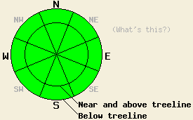
Recent observations have indicated that widespread stable snowpack conditions exist. Keep in mind that some degree of spacial variability is always present. Very isolated areas of instability are unlikely, but certainly not impossible. Increasing west winds yesterday and last night have become strong enough to move snow. A small amount of wind loading may exist near and above treeline in lee areas, mainly on NE-E-SE aspects. Any recently formed slabs or pillows of wind transported snow are expected to be small and not present a significant hazard to backcountry travelers.
| 0600 temperature: | 14 to 24 deg. F. |
| Max. temperature in the last 24 hours: | 33 to 41 deg. F. |
| Average wind direction during the last 24 hours: | West |
| Average wind speed during the last 24 hours: | 25 mph |
| Maximum wind gust in the last 24 hours: | 49 mph |
| New snowfall in the last 24 hours: | O inches |
| Total snow depth: | 70 to 99 inches |
For 7000-8000 ft: |
|||
| Sunday: | Sunday Night: | Monday: | |
| Weather: | Mostly sunny skies. | Mostly clear skies. | Mostly sunny skies with increasing high clouds in the morning. Becoming mostly cloudy by mid afternoon. |
| Temperatures: | 24 to 29 deg. F. | 10 to 15 deg. F. | 25 to 30 deg. F. |
| Wind direction: | W | NE shifting to E | E |
| Wind speed: | 10 to 20 mph. | 10 to 20 mph with gusts to 30 mph after midnight. | 10 to 20 mph with gusts to 30 mph in the morning. Winds decreasing to 5 to 10 mph in the afternoon. |
| Expected snowfall: | O in. | O in. | O in. |
For 8000-9000 ft: |
|||
| Sunday: | Sunday Night: | Monday: | |
| Weather: | Mostly sunny skies. | Mostly clear skies. | Mostly sunny skies with increasing high clouds in the morning. Becoming mostly cloudy by mid afternoon. |
| Temperatures: | 19 to 24 deg. F. | 13 to 18 deg. F. | 22 to 27 deg. F. |
| Wind direction: | W | NW shifting to E | E |
| Wind speed: | 15 to 25 mph with gusts to 45 mph. | 10 to 15 mph with gusts to 25 mph. Winds shifting and increasing to 15 to 25 mph with gusts to 50 mph after midnight. | 20 to 30 mph with gusts to 50 mph in the morning. Winds decreasing to 10 to 15 mph in the afternoon. |
| Expected snowfall: | O in. | O in. | O in. |


This website is owned and maintained by the non-profit arm of the Sierra Avalanche Center. Some of the content is updated by the USDA avalanche forecasters including the forecasts and some observational data. The USDA is not responsible for any advertising, fund-raising events/information, or sponsorship information, or other content not related to the forecasts and the data pertaining to the forecasts.

