In partnership with: 
|
January 18, 2011 at 8:01 am |
|
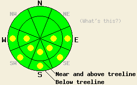
This morning the avalanche danger is LOW for all elevations and aspects. Pockets of MODERATE avalanche danger should form on the E-SE-S-SW-W aspects 35 degrees and steeper by midday due to daytime warming. |
|
|
|
After another day of record high temperatures across the region yesterday, the forecast calls for similar but slightly cooler weather today. Temperatures should begin to decease slightly as the strong high pressure starts to back away from the region towards the west. Daytime highs should still reach into the upper 40's above 7000 ft today. As this high moves westward, it will allow a cold front to drop into the Great Basin bringing much colder air and stronger northerly winds to the forecast area. Temperatures should drop below freezing tonight and remain much cooler tomorrow with daytime highs in the low to mid 30's above 7000 ft.
Observations indicated that a very weak refreeze occurred on Sunday night. A thin variable refrozen crust existed on N-NE aspects on Red Lake Peak (photo) and on Silver Peak (photo) yesterday. On the southerly aspects, this refreeze did not last long. By 10 am several inches of unconsolidated, wet, sticky, surface snow existed on the southerly aspects up to 8000 ft on Silver Peak and up to 9200 ft on Red Lake Peak. In areas near rocks or bushes where a shallow snowpack exists on these southerly aspects, saturated, wet, unsupportable snow existed all the way to the ground. Large, skier-triggerred roller balls occurred on the southerly, sun-exposed slopes steeper than 35 degrees in the both these areas (photo from Silver, photo from Red Lake). Ski cuts on similar test slopes also triggerred some wet, loose snow sluffs on Silver Peak (photo).
Primary Avalanche Concern: Wet Snow Instabilities
Most of the remote sensors in the forecast area showed overnight lows above freezing but slightly colder than previous nights. A few remote sensors showed overnight lows slightly below freezing. More widespread cloud cover did develop over parts of the forecast area last night. Temperatures above freezing in most areas that have persisted for four days and patchy cloud cover should have prevented a deep, strong refreeze. As the day warms up and the sun comes out, whatever refreeze did occur last night will melt quickly on the E-SE-S-SW-W aspects. As the snow melts, the snowpack will weaken, and wet snow activity will become possible again today. Roller balls or wet, loose snow sluffs should comprise most of this wet snow activity. Some wet slides may occur on the most sun-exposed aspects on the southern half of the compass that are large enough to bury a person. Even if these wet snow instabilities do not entrain enough snow to bury a person, any of them (roller balls included) could push someone into an area that could have consequences. Use clues like shin-deep wet snow, roller balls, and wet snow sluffs to determine where wet snow instabilities may lurk.
This morning the avalanche danger is LOW for all elevations and aspects. Pockets of MODERATE avalanche danger should form on the E-SE-S-SW-W aspects 35 degrees and steeper by midday due to daytime warming.
| 0600 temperature: | 36-41 deg. F. |
| Max. temperature in the last 24 hours: | 48-51 deg. F. |
| Average wind direction during the last 24 hours: | North to Northeast |
| Average wind speed during the last 24 hours: | 15 mph |
| Maximum wind gust in the last 24 hours: | 48 mph |
| New snowfall in the last 24 hours: | O inches |
| Total snow depth: | 62-91 inches |
For 7000-8000 ft: |
|||
| Tuesday: | Tuesday Night: | Wednesday: | |
| Weather: | Partly cloudy | Partly cloudy | Partly cloudy |
| Temperatures: | 41-50 deg. F. | 28-32 deg. F. | 30-36 deg. F. |
| Wind direction: | North to Northeast | West | Northwest to Northeast |
| Wind speed: | up to 10 mph | 10 mph increasing to 10-15 mph with gusts to 30 mph after midnight | 10 mph increasing to 10-15 mph with gusts to 25 mph in the afternoon |
| Expected snowfall: | O in. | O in. | O in. |
For 8000-9000 ft: |
|||
| Tuesday: | Tuesday Night: | Wednesday: | |
| Weather: | Partly cloudy | Partly cloudy | Partly cloudy |
| Temperatures: | 39-44 deg. F. | 23-29 deg. F. | 27-32 deg. F. |
| Wind direction: | North to Northeast | Northwest | Northwest to Northeast |
| Wind speed: | 10 mph increasing to 10-15 mph with gusts to 40 mph this afternoon | 15-25 mph with gusts to 40 mph increasing to 20-30 mph with gusts to 55 mph | 15-25 mph with gusts to 60 mph |
| Expected snowfall: | O in. | O in. | O in. |


This website is owned and maintained by the non-profit arm of the Sierra Avalanche Center. Some of the content is updated by the USDA avalanche forecasters including the forecasts and some observational data. The USDA is not responsible for any advertising, fund-raising events/information, or sponsorship information, or other content not related to the forecasts and the data pertaining to the forecasts.

