In partnership with: 
|
January 19, 2011 at 7:34 am |
|
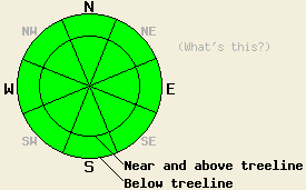
Avalanche danger is LOW for all elevations and aspects. Normal caution is advised. |
|
|
|
A cold front is passing through the forecast area this morning. In response, winds have shifted from east to west overnight and increased to moderate in speed. This has mixed out the air temperature inversion that existed over the forecast area for the past several days. Below freezing air temperatures have returned to locations above 6,500'. Ridgetop winds are expected to shift to the northwest and then on to northeast as the day progresses. Winds are forecast to increase to moderate to strong in speed. Today's maximum daytime air temperatures are expected at 10 to 15 degrees colder than yesterday at the mid and upper elevations and 5 to 8 degrees colder at the lower elevations.
Observations made yesterday afternoon on Mt. Judah (Donner Summit area) revealed that a better than anticipated overnight refreeze had occurred. Light to moderate east winds and slightly cooler air temperatures aided in keeping the snow surface from melting as much as in the past several days. In the general area between 7,100' and 8,200', N and W aspects remained frozen all day. E aspects had 1 to 2 cm of snow surface melt that refroze by 2:30 pm and was supportable crust by 3:30 pm. Significant melting only occurred on SE-S-SW aspects. Boot pen on an open S aspect at 7,550' at 2:45 pm was 4 inches. Free water from the Dec 13 rain event and recent melt freeze conditions of the past several days had percolated through at least the top 3.3 feet of the snowpack and likely deeper at this location (pit profile). Ski cuts on 40 to 45 degree convex slope features on S aspects failed to produce any roller balls or wet snow sluffs.
Avalanche Concerns:
Avalanche concerns for today are few. With air temperatures at the mid and upper elevations dropping below freezing overnight for the first time in several days a solid overnight refreeze of the snow surface is expected to have occurred. A much thicker surface crust than what formed the past several nights from radiational cooling alone should be evident today. With maximum daytime air temperatures forecast in the mid 20s to mid 30s for areas above 7,000' the snow surface is expected to remain strong and supportable all day. Moderate to strong northerly winds will cause some convective cooling of the snow surface today. Snow surface melting of more than a inch or so will likely only occur on low and mid elevation SE-S-SW aspects. The snow surface in most other areas on W-NW-N-NE-E aspects is expected to remain frozen all day. A fall in these areas could result in long and difficult to arrest or uncontrolled sliding over the ice. A long sliding fall resulting in impact with trees and rocks or cliff exposure below may be the most significant hazard to backcountry travelers today.
| 0600 temperature: | 27 to 32 deg. F. |
| Max. temperature in the last 24 hours: | 39 to 48 deg. F. |
| Average wind direction during the last 24 hours: | East shifting to west |
| Average wind speed during the last 24 hours: | 22 mph |
| Maximum wind gust in the last 24 hours: | 57 mph |
| New snowfall in the last 24 hours: | O inches |
| Total snow depth: | 62 to 91 inches |
For 7000-8000 ft: |
|||
| Wednesday: | Wednesday Night: | Thursday: | |
| Weather: | Partly cloudy skies. | Clear skies. | Sunny skies. |
| Temperatures: | 30 to 36 deg. F. | 18 to 24 deg. F. | 33 to 43 deg. F. |
| Wind direction: | NW shifting to NE | E | E |
| Wind speed: | 10 to 15 mph with gusts to 35 mph. | 10 to 20 mph with gusts to 40 mph. | 10 to 15 mph with gusts to 25 mph in the morning. |
| Expected snowfall: | O in. | O in. | O in. |
For 8000-9000 ft: |
|||
| Wednesday: | Wednesday Night: | Thursday: | |
| Weather: | Partly cloudy skies. | Clear skies. | Sunny skies. |
| Temperatures: | 27 to 34 deg. F. | 20 to 26 deg. F. | 32 to 38 deg. F. |
| Wind direction: | NW shifting to NE | E | E shifting to SE |
| Wind speed: | 20 to 35 mph with gusts to 55 mph. Winds increasing to 25 to 45 mph with gusts to 70 mph in the afternoon. | 35 to 50 mph with gusts to 70 mph. | 30 to 45 mph with gusts to 60 mph. Winds decreasing to 10 to 15 mph with gusts to 30 mph in the afternoon. |
| Expected snowfall: | O in. | O in. | O in. |


This website is owned and maintained by the non-profit arm of the Sierra Avalanche Center. Some of the content is updated by the USDA avalanche forecasters including the forecasts and some observational data. The USDA is not responsible for any advertising, fund-raising events/information, or sponsorship information, or other content not related to the forecasts and the data pertaining to the forecasts.

